The Lesotho Highlands Water Project
| Geolocation: | -29° 30' 53.2238", 28° 34' 47.2732" |
|---|---|
| Total Watershed Population: | 13,002,500 million |
| Total Watershed Area: | 944,051 km2364,498.091 mi² |
| Climate Descriptors: | Dry-summer, temperate |
| Predominant Land Use Descriptors: | rangeland, urban |
| Important Uses of Water: | Agriculture or Irrigation, Domestic/Urban Supply, Hydropower Generation |
Contents
Summary
Development in Lesotho has been limited by its lack of natural resources and investment capital. Water is its only abundant resource, which is precisely what regions of neighboring South Africa have been lacking. A project to transfer water from the Senqu River to South Africa had been investigated in the 1950s, and again in the 1960s. The project was never implemented due to disagreement over appropriate payment for the water. In 1978, the governments of Lesotho and South Africa appointed a joint technical team to investigate the possibility of a water transfer project. A treaty between the two states was necessary to negotiate for this international project. Negotiations proceeded through 1986 and the "Treaty on the Lesotho Highlands Water Project between the Government of the Kingdom of Lesotho and the Government of the Republic of South Africa " was signed into law on October 24, 1986. The Treaty spells out an elaborate arrangement of technical, economic, and political intricacy. . The water transfer component was entirely financed by South Africa, which would also make payments for the water that would be delivered. The hydropower and development components were undertaken by Lesotho, which received international aid from a variety of donor agencies, particularly the World Bank. Phase IA of the Lesotho Highlands Water Project was completed in 1998, at a cost of $2.4 billion. Phase IB of the project was completed in early 2004, as a cost of approximately $1.5 billion. The Lesotho Highlands Water Project provides lessons in the importance of an integrated approach to negotiating the allocation of a "basket" of resources. South Africa receives cost-effective water for its continued growth, while Lesotho receives revenue and hydropower for its own development.
Natural, Historic, Economic, Regional, and Political Framework
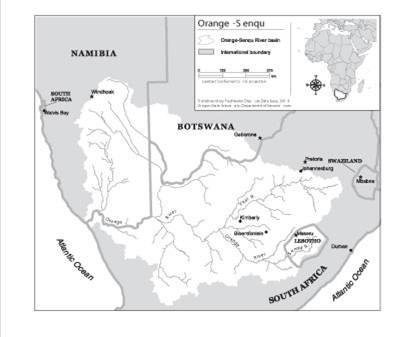
 Image 1. Map of the Senqu River (Lesotho Highlands Project)[1]
Issues and Stakeholders
Analysis, Synthesis, and Insight
Key Questions
- ^ Product of the Transboundary Freshwater Dispute Database, Department of Geosciences, Oregon State University. Additional information about the TFDD can be found at:http://www.transboundarywaters.orst.edu/research/case_studies/Lesotho_Highlands_New.htm
| Area | 944,051 km² (364,498.091 mi²) + |
| Climate | Dry-summer + and temperate + |
| Geolocation | -29° 30' 53.2238", 28° 34' 47.2732"Latitude: -29.5147844 Longitude: 28.5797981 + |
| Land Use | rangeland + and urban + |
| Population | 13,002,500 million + |
| Water Use | Agriculture or Irrigation +, Domestic/Urban Supply + and Hydropower Generation + |
 This is a


