File list
This special page shows all uploaded files.
| Date | Thumbnail | Size | User | Description | Versions | |
|---|---|---|---|---|---|---|
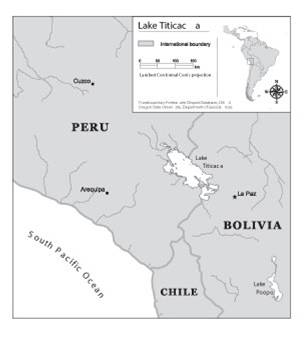
| 16:41, 27 August 2012 | Laketiticacatfddimage.jpg (file) |  |
11 KB | Mpritchard | Wide use of electronic and hardcopy versions of data, GIS coverages, and findings produced by the Transboundary Freshwater Dispute Database (TFDD) project is encouraged. The data, coverages, and findings are not copyrighted, although due credit is apprec | 1 |
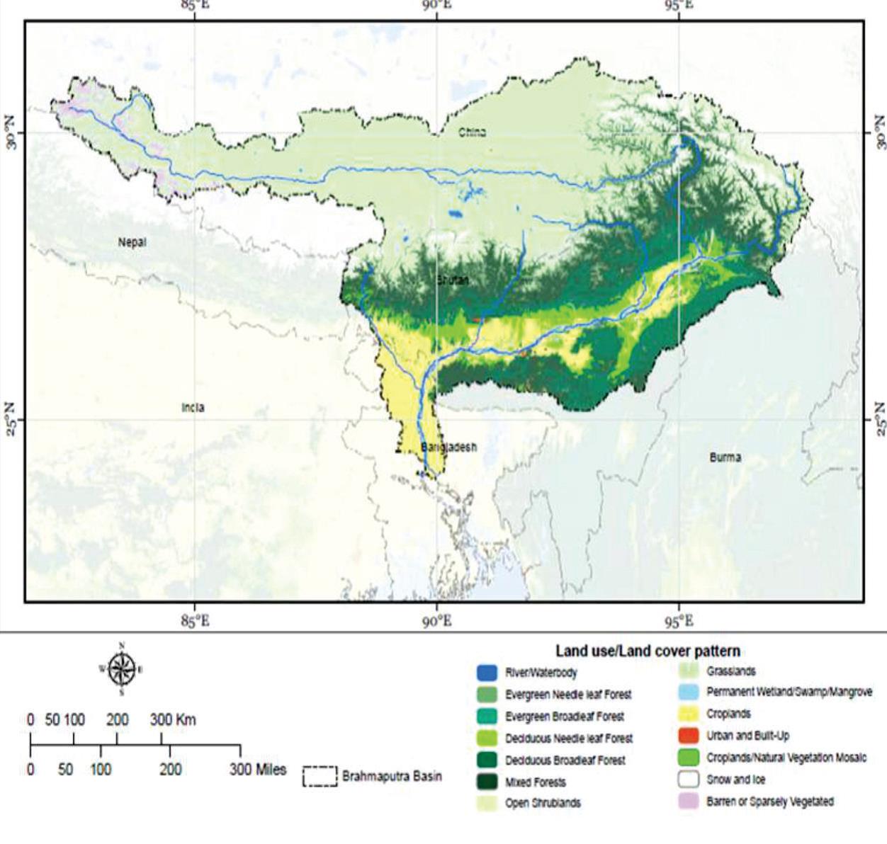
| 16:16, 23 May 2017 | Land Use Land Cover in the Brahmaputra sub-basin.jpg (file) |  |
132 KB | Cindynoe | 1 | |
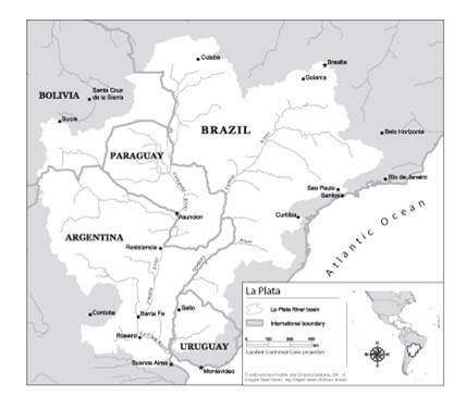
| 14:16, 1 August 2012 | Laplata.jpg (file) |  |
18 KB | Mpritchard | Wide use of electronic and hardcopy versions of data, GIS coverages, and findings produced by the Transboundary Freshwater Dispute Database (TFDD) project is encouraged. The data, coverages, and findings are not copyrighted, although due credit is apprec | 1 |
| 20:51, 7 January 2014 | Lebanon Aquapedia Research Lebanon TYates.docx (file) | 3.7 MB | Tmyates | 1 | ||
| 11:27, 29 August 2012 | Lesotho Highlands.jpg (file) |  |
17 KB | Mpritchard | Wide use of electronic and hardcopy versions of data, GIS coverages, and findings produced by the Transboundary Freshwater Dispute Database (TFDD) project is encouraged. The data, coverages, and findings are not copyrighted, although due credit is apprec | 1 |
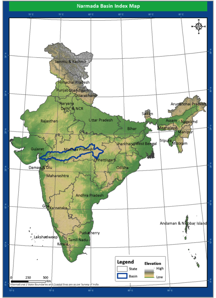
| 21:41, 23 May 2014 | Location.png (file) |  |
567 KB | Rachel | Location of the Narmada River Basin | 1 |
| 22:37, 26 March 2012 | Location of Indus River.jpg (file) |  |
152 KB | Administrator | 1 | |
| 12:03, 15 May 2013 | Logo size watersplash.png (file) |  |
10 KB | ACR | 2 | |
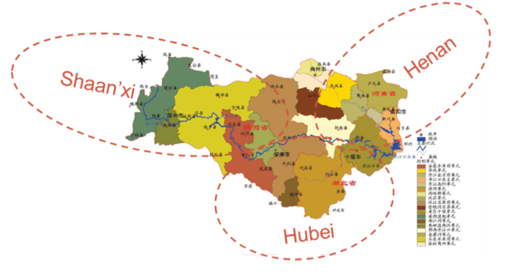
| 09:39, 6 June 2012 | MRP case provinces.jpg (file) |  |
360 KB | Amanda | 18 Water Quality Control Zone in Danjiangkou Reservoir Watershed in three provinces Water Pollution Control & Soild and Water Conservation Plan Drafting Committee Water Pollution Control & Soil and Water Conservation Plan of Danjiangkou Reservoir and Up | 1 |
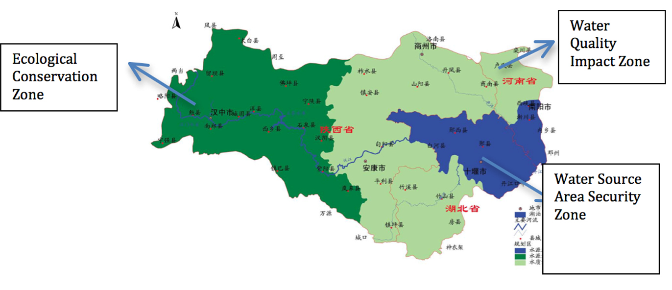
| 09:10, 6 June 2012 | MRP zones image.jpg (file) |  |
271 KB | Amanda | Adapted from Water Pollution Control & Soild and Water Conservation Plan Drafting Committee Water Pollution Control & Soil and Water Conservation Plan of Danjiangkou Reservoir and Upstream. (2005). Base image used without permission under good faith use | 1 |
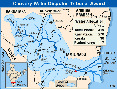
| 20:32, 24 May 2017 | Main-qimg-5ae85ce6607bb653b8c34f587c6be1ea.gif (file) |  |
26 KB | Shekharc | Cauvery River Basin Source: The Economic Times. Retrieved on May 24, 2017. | 1 |
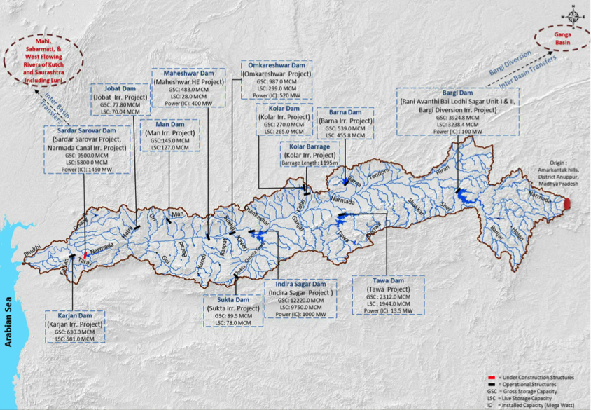
| 21:41, 23 May 2014 | Major projects.png (file) |  |
837 KB | Rachel | Major Water Resource Projects in the Narmada Basin | 1 |
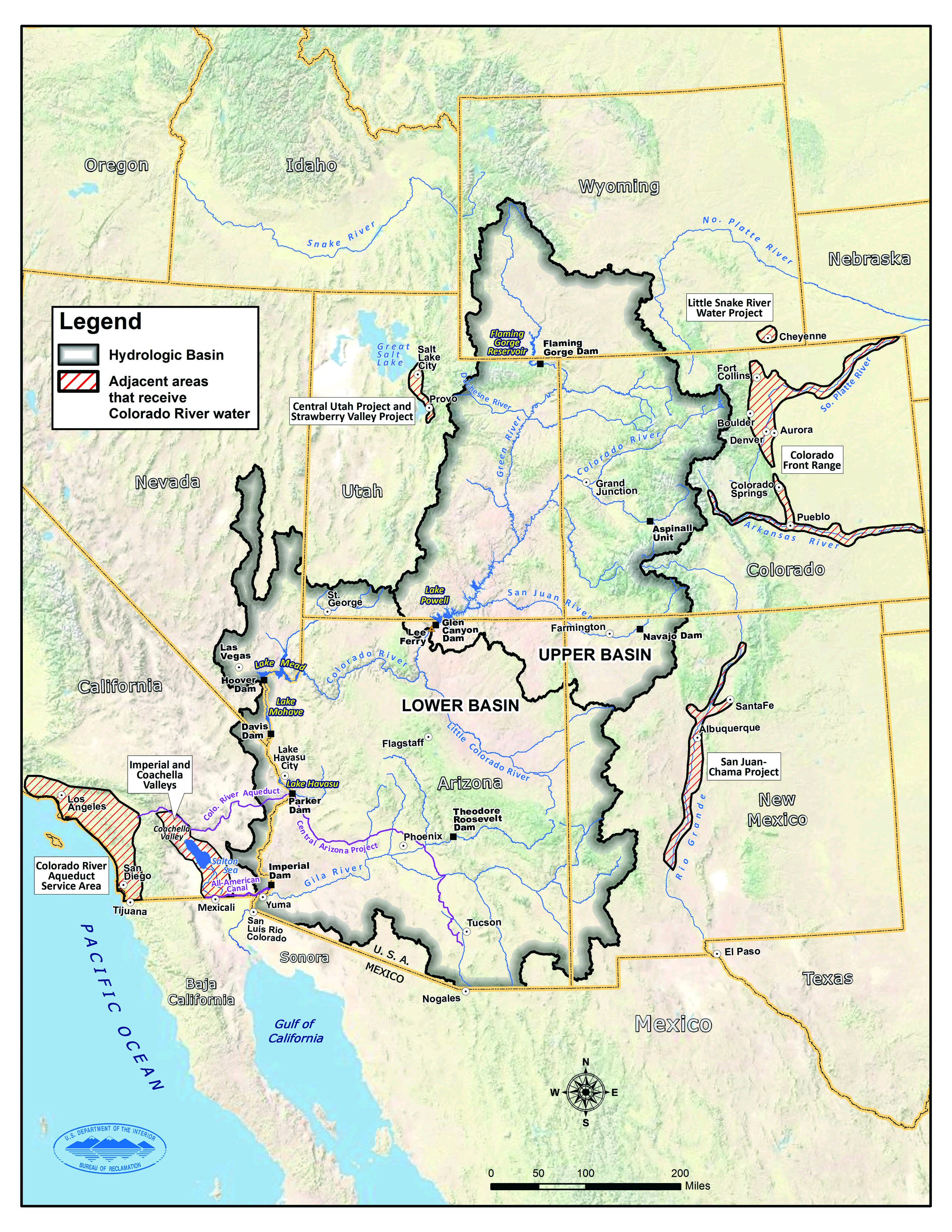
| 10:15, 25 May 2017 | Map.jpg (file) |  |
1.37 MB | Keefe | Source: https://www.usbr.gov/lc/region/programs/crbstudy.html | 1 |
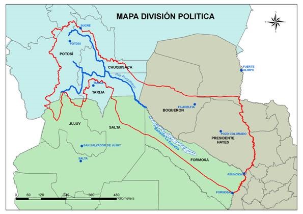
| 18:32, 25 May 2017 | Map PilcomayoBasin.jpg (file) |  |
49 KB | Julian Kölbel | This map delineates the Pilcomayo River Basin and shows how it is shared between the riparian states Bolivia, Paraguay, and Argentina. It also shows how the Pilcomayo forms extensive wetlands at the border between Paraguay and Argentina, called the Ban... | 2 |
| 10:19, 25 May 2017 | Map coloradoriverbasin.jpg (file) |  |
1.37 MB | Keefe | Source: https://www.usbr.gov/lc/region/programs/crbstudy.html | 1 |
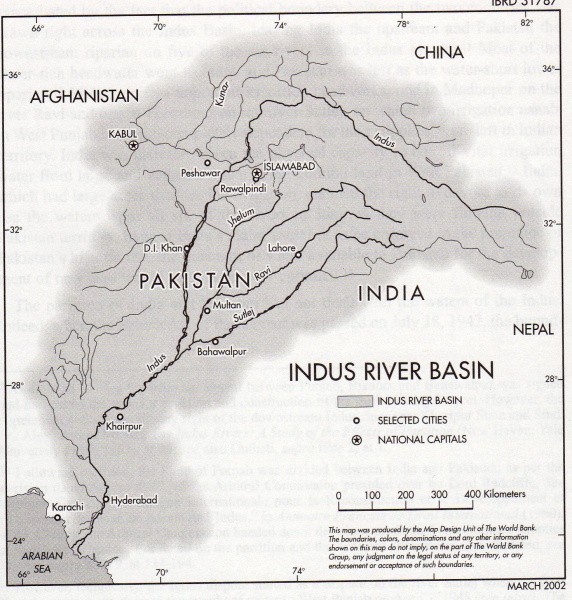
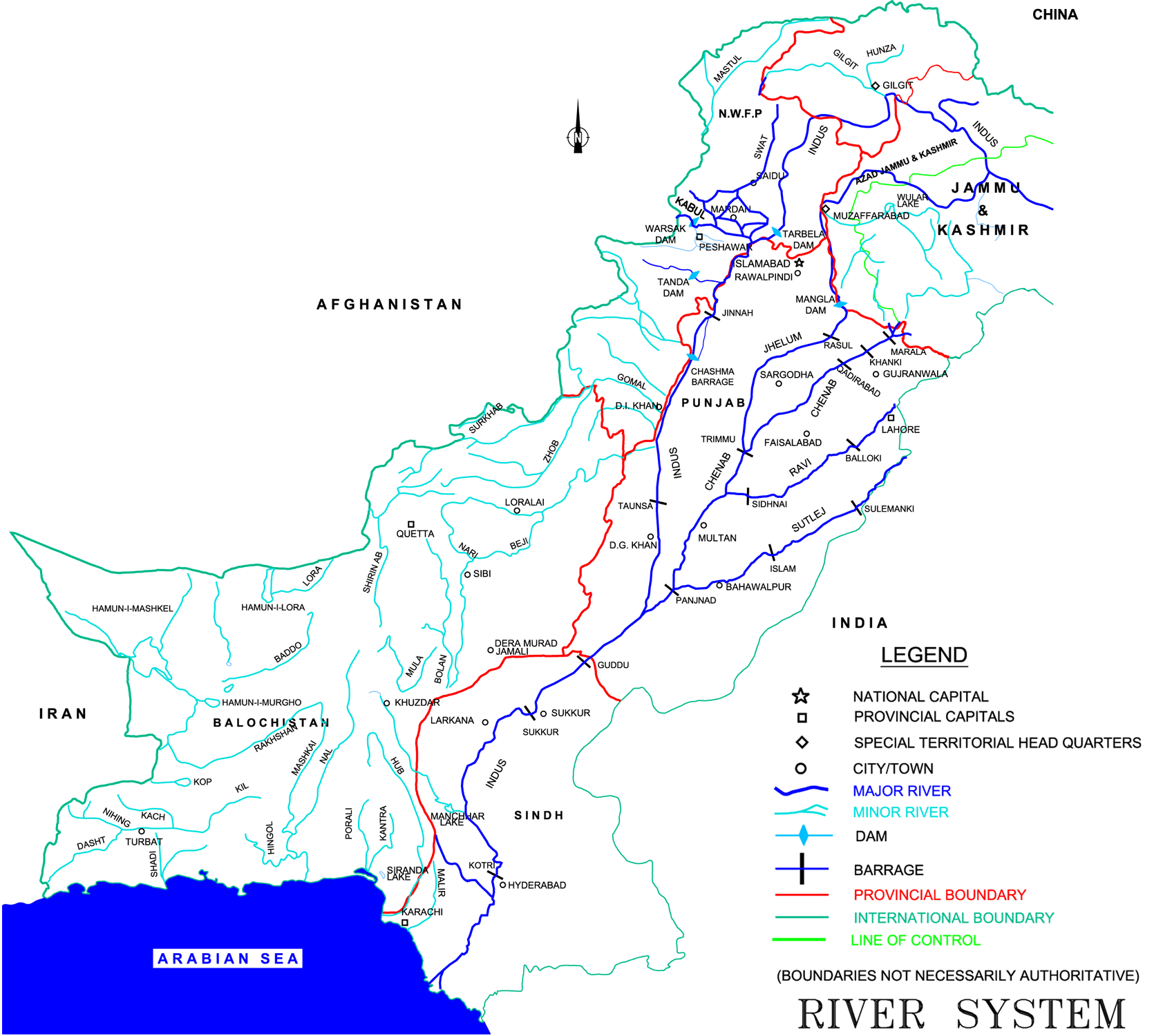
| 08:46, 30 January 2015 | Map of Indus Basin.png (file) |  |
180 KB | Ashfaqm | Map of Indus River Sysetm Figure 2.2 in Ministry of Water and Power. 2002. Pakistan Water Sector Strategy Report v2, p19. Available online: http://waterinfo.net.pk/sites/default/files/knowledge/Pakistan%20Water%20Sector%20Strategy%20-%20Vol%202.pdf | 1 |
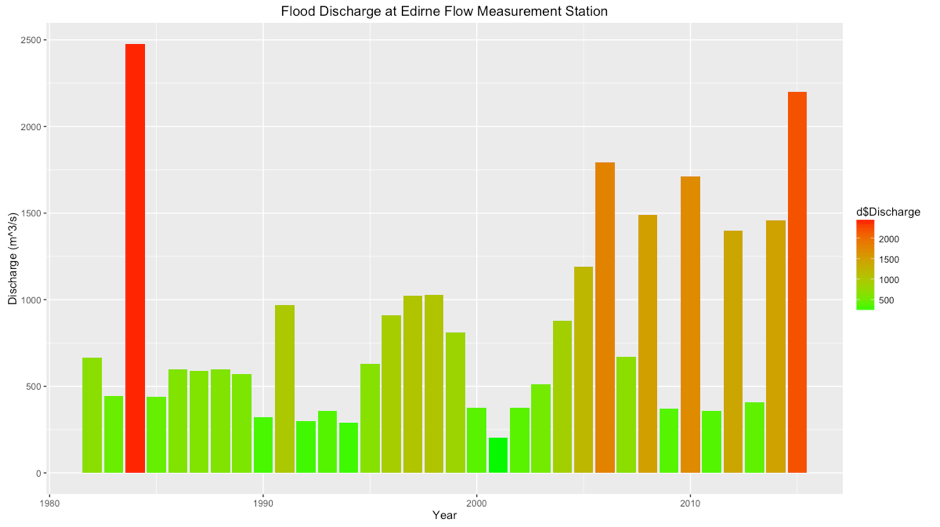
| 16:36, 29 May 2017 | MaritsaFlow.png (file) |  |
44 KB | OzgurB | 1 | |
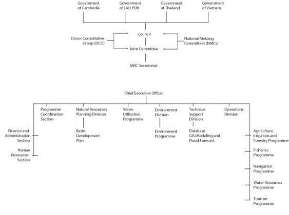
| 13:33, 2 August 2012 | Mekongcommitteeorgchart.jpg (file) |  |
18 KB | Mpritchard | Wide use of electronic and hardcopy versions of data, GIS coverages, and findings produced by the Transboundary Freshwater Dispute Database (TFDD) project is encouraged. The data, coverages, and findings are not copyrighted, although due credit is apprec | 1 |
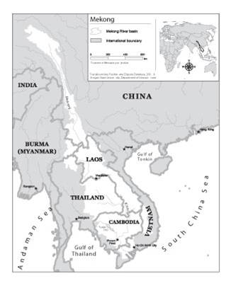
| 13:11, 2 August 2012 | Mekongriverbasin.jpg (file) |  |
17 KB | Mpritchard | Map of the Mekong River Basin. Wide use of electronic and hardcopy versions of data, GIS coverages, and findings produced by the Transboundary Freshwater Dispute Database (TFDD) project is encouraged. The data, coverages, and findings are not copyrighted | 1 |
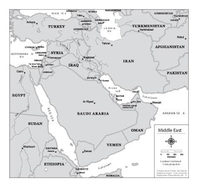
| 14:27, 15 August 2012 | Middleeastwater.jpg (file) |  |
20 KB | Mpritchard | Wide use of electronic and hardcopy versions of data, GIS coverages, and findings produced by the Transboundary Freshwater Dispute Database (TFDD) project is encouraged. The data, coverages, and findings are not copyrighted, although due credit is apprec | 1 |
| 13:23, 13 June 2012 | Murillo rafferty ilisu network.png (file) |  |
503 KB | Amanda | Network respresentation of issues/stakeholders for analysis of the Ilisu Dam Project in Turkey by Maria E. Martinez Murillo C. and Mark Rafferty Originally prepared in conjunction with WD III Seminar (Tufts University) course requirements. | 1 |
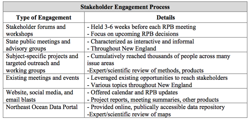
| 11:12, 22 May 2017 | NEPRB Stakeholder Engagement.png (file) |  |
265 KB | Lauren | 1 | |
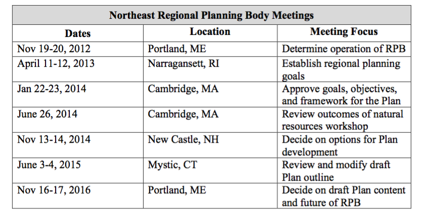
| 11:11, 22 May 2017 | NERPB meetings.png (file) |  |
201 KB | Lauren | 1 | |
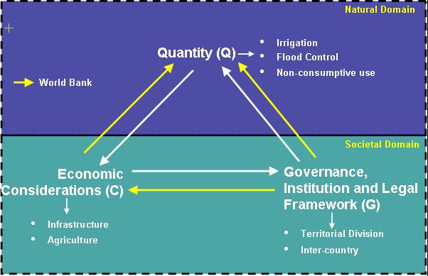
| 22:37, 26 March 2012 | NSS framework for IWT.jpg (file) |  |
33 KB | Administrator | 1 | |
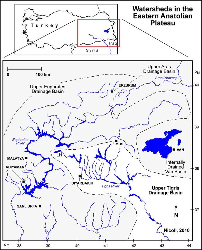
| 11:53, 13 June 2012 | Nicoll tigris fig3.jpg (file) |  |
368 KB | Amanda | screen resolution | 1 |
| 07:32, 26 October 2014 | Nile GERD AHD hydrology.pdf (file) | 3.2 MB | Tesfay | Recently published Modeling of two cascade and cross-border dams; the impact of the Grand Ethiopian Renascence Dam on the Egyptian Aswan Dam. An article focused on the Nile basin water management. | 1 | |
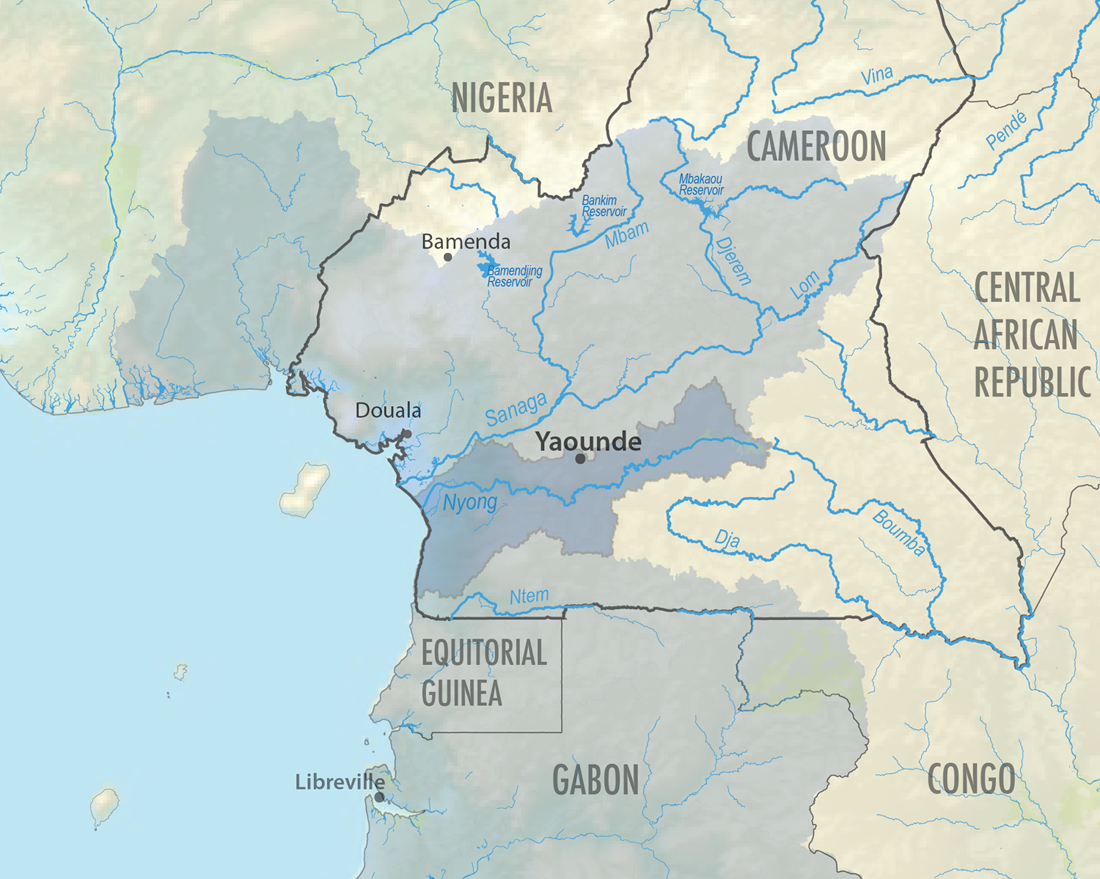
| 11:10, 24 September 2013 | Nyong-GulfofGuinea-Cameroon.png (file) |  |
619 KB | Amanda | The Nyong River Basin in Cameroon is one of the basins of Cameroon that drains to the Gulf of Guinea. This map was produced by Water Diplomacy for the AquaPedia Case Study Database. Data Sources: GADM v2.0 (Administrative Boundaries) and FAO AQUASTAT... | 1 |
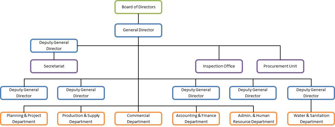
| 12:52, 20 May 2013 | PPWSA Governance.jpg (file) |  |
49 KB | TAlarcon | Created by Tania Alarcon Data Source: Phnom Penh Water Supply Authority. (2013). History. Organization Structure. Production System. Distribution System. Water Quality. Non Revenue Water. Retrieved from: www.ppwsa.com.kh/en/index.php?page=history | 1 |
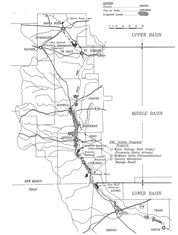
| 19:13, 29 April 2014 | PecosMap.png (file) |  |
163 KB | Mattfitz | A detailed map of the Pecos River Basin in New Mexico from [Kraai, 1993] | 1 |
| 13:56, 16 July 2012 | Question book edit.png (file) |  |
5 KB | Amanda | This file was edited from a file available from http://en.wikipedia.org/wiki/File:Question_book-new.svg (which was created by Wikipedia user Tkgd2007, and based on a similar image created by a different user). Image is available for use by anyone under a | 1 |
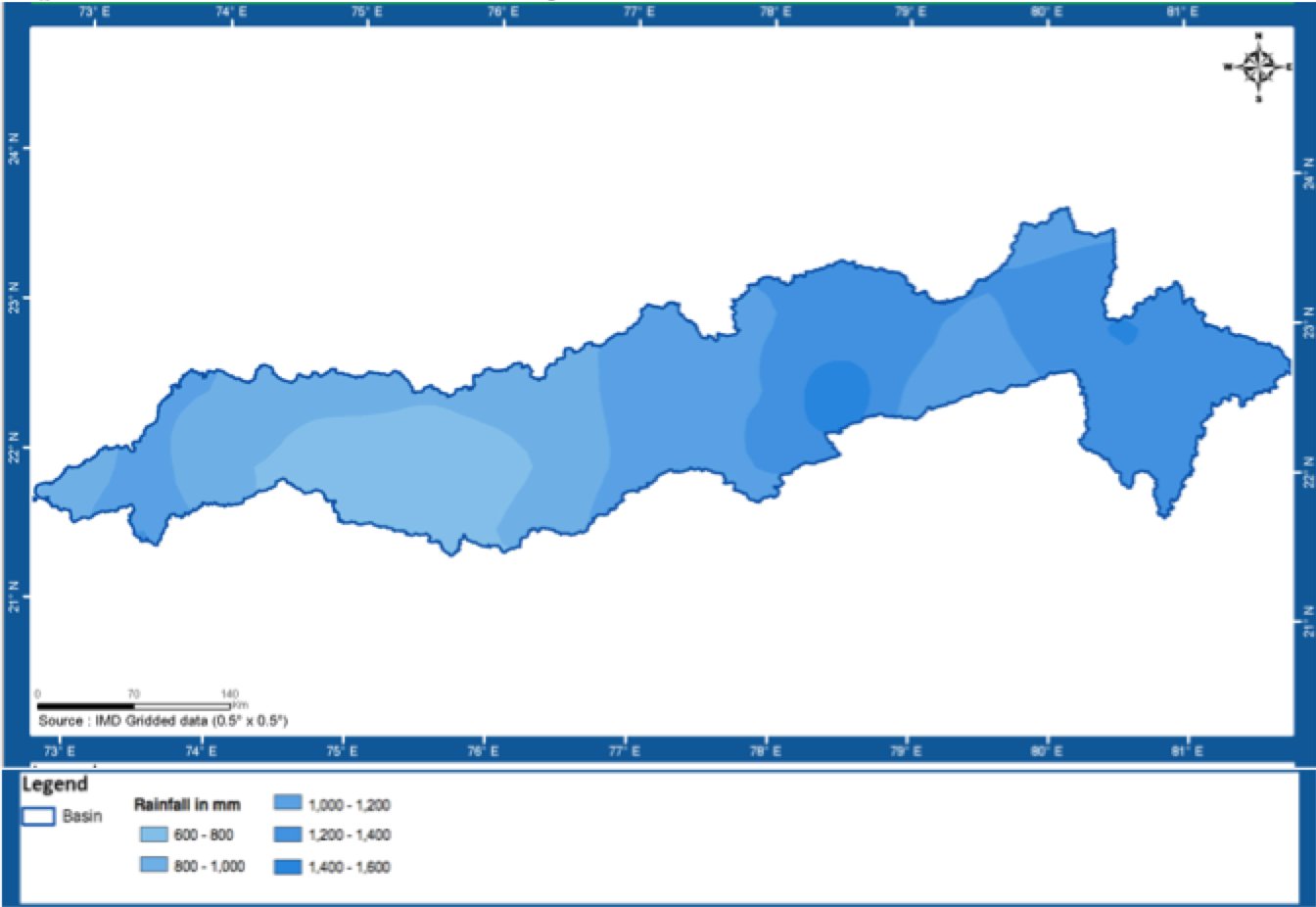
| 21:43, 23 May 2014 | Rainfall.png (file) |  |
207 KB | Rachel | Narmada Basin Annual Average Rainfall | 1 |
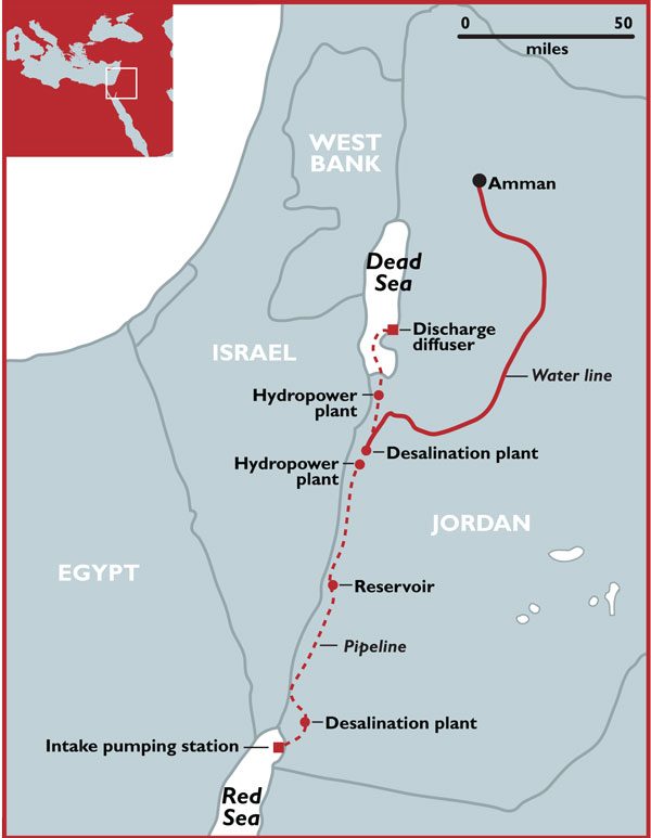
| 07:24, 25 May 2017 | Red-dead-sea.jpg.scale.LARGE.jpg (file) |  |
48 KB | Stolgay | The Red to Dead Sea Conveyance project includes a 180-kilometre pipeline engineered to carry up to two billion cubic metres of seawater per year from the Gulf of Aqaba on the Red Sea through Jordanian territory to the Red Sea as well as hydropower plan... | 1 |
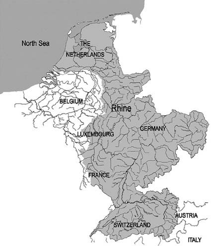
| 13:00, 15 May 2014 | Rhine River Basin.jpg (file) |  |
46 KB | Jcheung6 | 1 | |
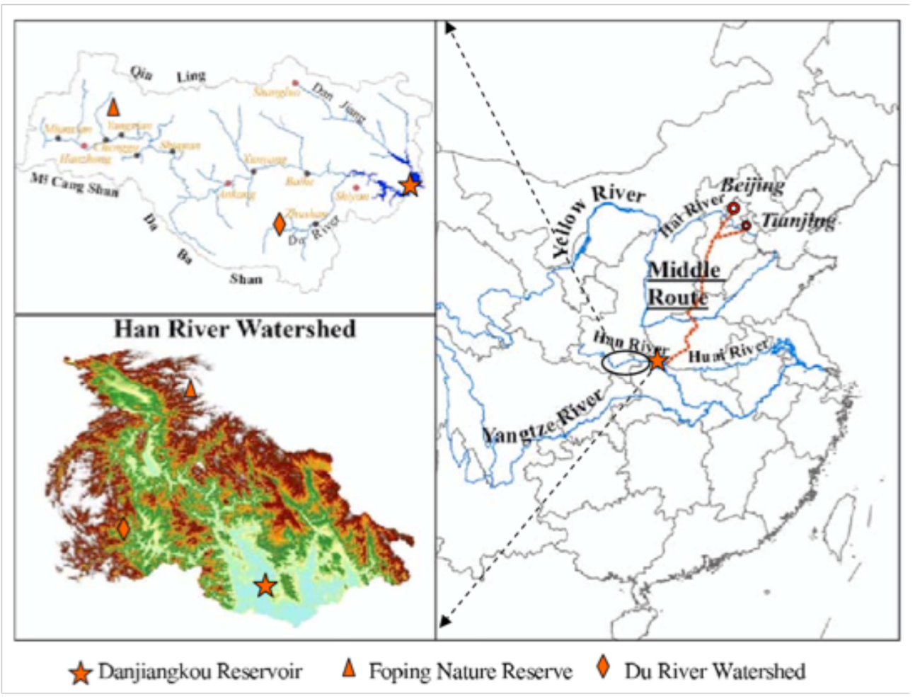
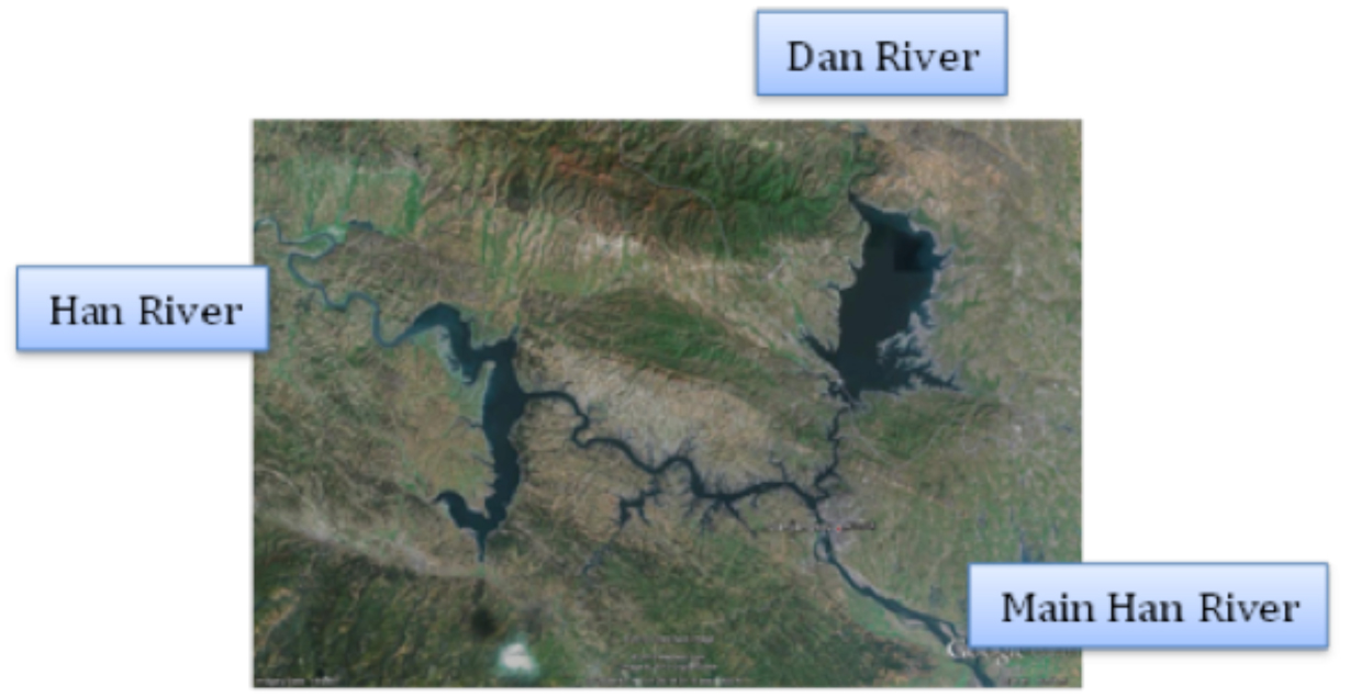
| 08:21, 6 June 2012 | River project watershed Zhang2009.jpg (file) |  |
456 KB | Amanda | Image from: Zhang, Q., Xu, Z., Shen, Z., Li, S. & Wang, S. The Han River watershed management initiative for the South-to-North water transfer project (Middle Route) of China. ''Environmental monitoring and assessment'' 148, 369–377 (2009). Used to des | 1 |
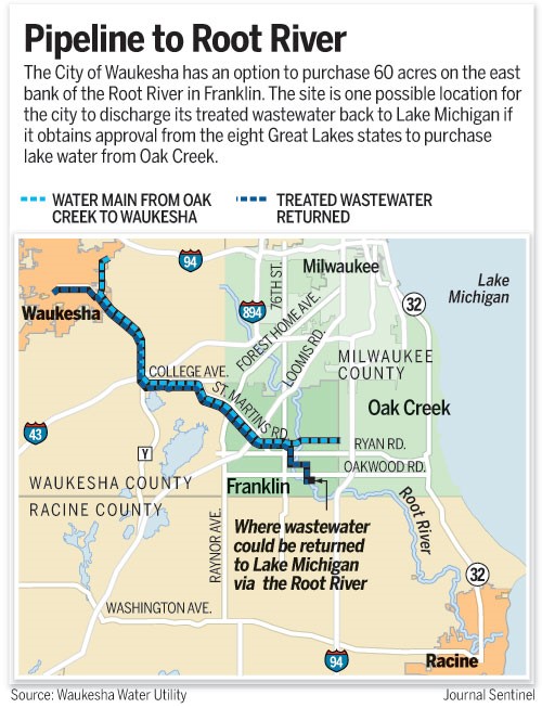
| 19:20, 21 May 2014 | Root River Pipeline.jpg (file) |  |
101 KB | B Finney | This image was taken from: http://www.jsonline.com/news/waukesha/waukesha-buys-option-on-land-for-root-river-discharge-ce8jmke-189591171.html | 1 |
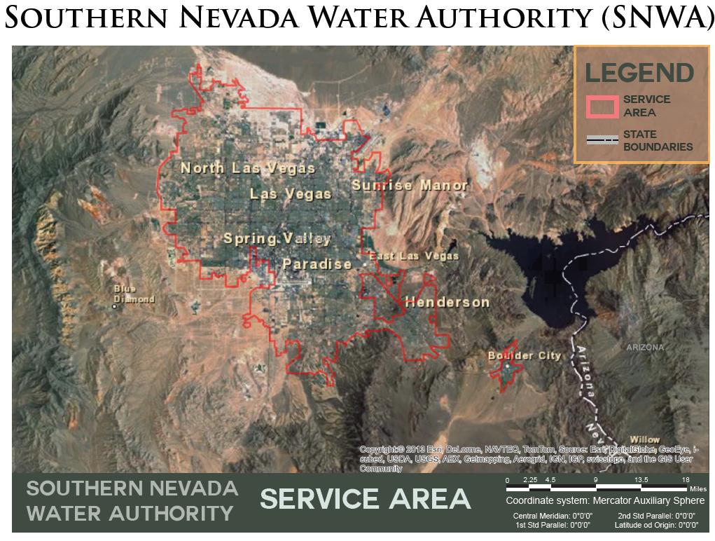
| 15:25, 14 May 2013 | SNWAMap.jpg (file) |  |
151 KB | Amanda | 2 | |
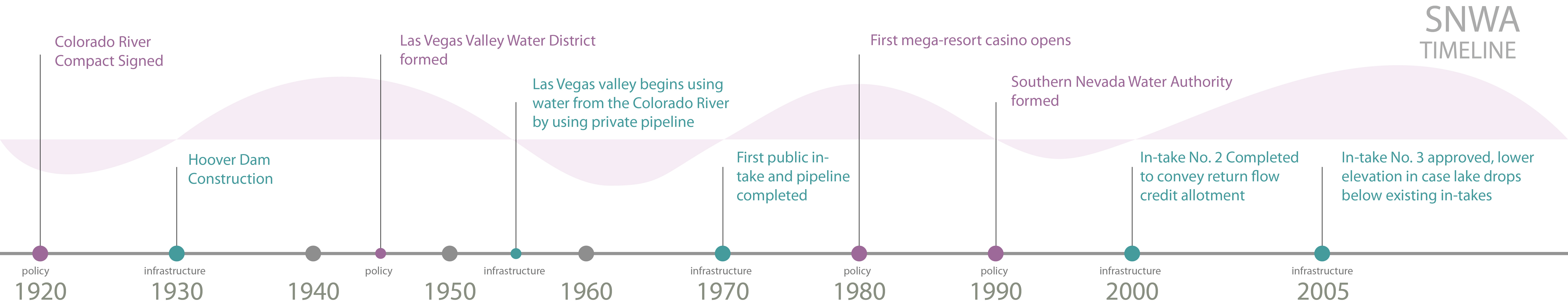
| 15:02, 14 May 2013 | SNWA Timeline 1920 - 2005.jpg (file) | 857 KB | Amanda | Produced by Margaret Garcia for Water Competition & Cooperation in the Las Vegas Valley | 1 | |
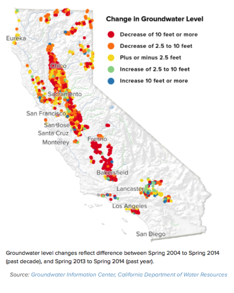
| 09:57, 1 November 2017 | Sal2.png (file) |  |
620 KB | SamKumasaka | Change in Groundwater Level 2004-2014 Groundwater Information Center, CA Department of Water Resources | 1 |
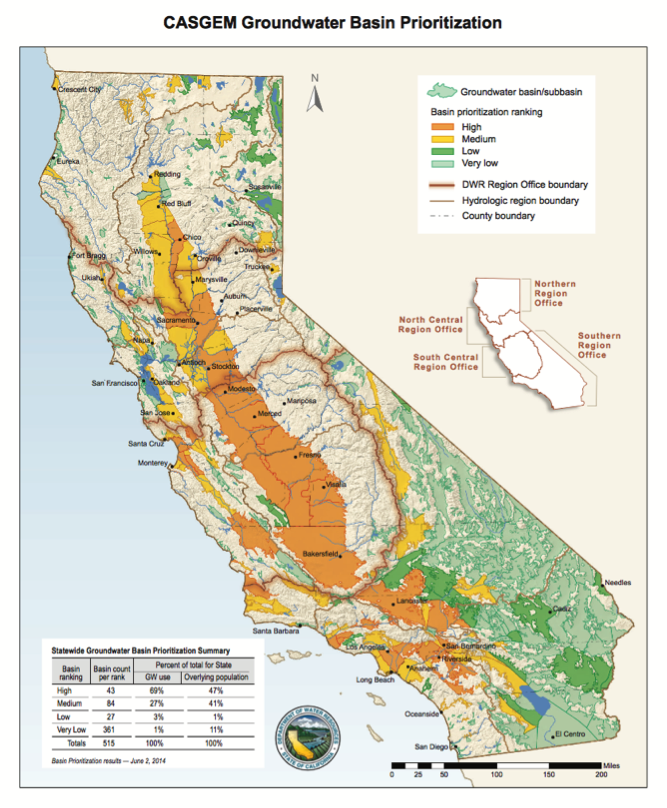
| 09:59, 1 November 2017 | Sal3.png (file) |  |
626 KB | SamKumasaka | CASGEM Groundwater Basin Prioritization | 1 |
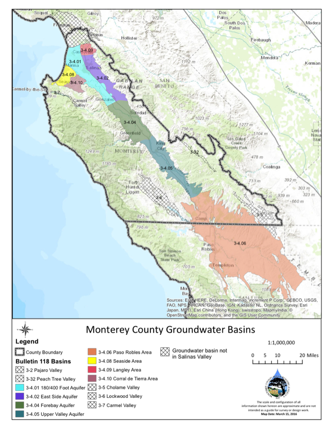
| 10:04, 1 November 2017 | Sal4.png (file) |  |
697 KB | SamKumasaka | Monterey County Groundwater Sub-basins | 1 |
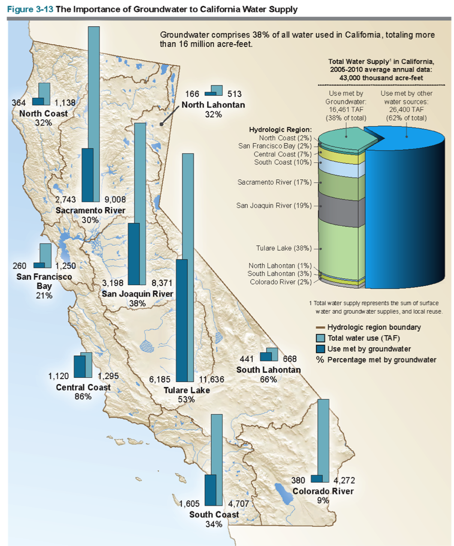
| 10:07, 1 November 2017 | Sal5.png (file) |  |
1.06 MB | SamKumasaka | The Importance of Groundwater to California Water Supply Groundwater comprises 38% of all water used in California, totaling more than 16 million acre-feet. Source: CA DWR | 1 |
| 10:10, 1 November 2017 | Sal6.png (file) |  |
207 KB | SamKumasaka | DIAGRAM: Groundwater Stakeholder Forum, Collaborative Work Group, and Committee Meetings | 1 |
| 10:13, 1 November 2017 | Sal7.png (file) |  |
407 KB | SamKumasaka | Salinas Valley Groundwater Advisory Committee Represented Organizations | 1 |
| 18:19, 31 October 2017 | Salinas GSA Process Roadmap.png (file) |  |
43 KB | SamKumasaka | Process Roadmap for SGMA Implementation/GSA Formation in Salinas Valley Groundwater Basin Created by Gina Bartlett (CBI, 2016) - https://www.svbgsa.com/process-timeline/ | 1 |
| 16:58, 18 January 2016 | Salton Pano.jpg (file) | 9.11 MB | JRozek | Source: https://www.flickr.com/photos/on_earth/14523087446 License: https://creativecommons.org/licenses/by/2.0/ | 1 | |
| 11:47, 6 August 2012 | Salweenriverbasin.jpg (file) |  |
14 KB | Mpritchard | Wide use of electronic and hardcopy versions of data, GIS coverages, and findings produced by the Transboundary Freshwater Dispute Database (TFDD) project is encouraged. The data, coverages, and findings are not copyrighted, although due credit is apprec | 1 |
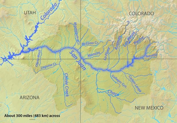
| 00:14, 22 May 2017 | Sanjuanrivermap.jpg (file) |  |
247 KB | Smithgri | Map of San Juan River Basin | 1 |
| 09:27, 6 June 2012 | Satellite of MRP region.jpg (file) |  |
285 KB | Amanda | Public Domain Satellite Image Screenshot. Labelled by Rose Wang and Kelly DeAngelis, 2012 | 1 |
| 09:53, 9 January 2014 | Schematic of Govt Water Data Exchange Lebanon UNESCWA.png (file) |  |
39 KB | Amanda | Data Exchange between government water stakeholders in Lebanon (UNESCWA) This figure is from UNESCWA. WATER IN LEBANON STRATEGIC MANAGEMENT DATA NATIONAL ASSESSMENT MATRIX. 2012. Presentation PDF Online at https://unstats.un.org/unsd/envaccounting/wo... | 1 |
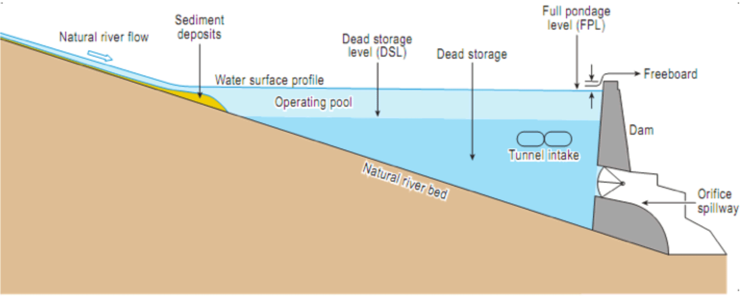
| 11:11, 29 January 2015 | Schematic side view typical dam.png (file) |  |
67 KB | Ashfaqm | A generic schematic showing the side view of a typical dam with low-level outlets. This graphic is from the Court of Arbitration (CoA) 2013a. Partial Award Indus Waters Kishenganga Arbitration (Pakistan v. India) (18 February). Documents linked for do... | 1 |
First page |
 Previous page |
 Next page |
Last page |


