File list
This special page shows all uploaded files.
| Date | Name | Thumbnail | User | Description | Versions | |
|---|---|---|---|---|---|---|
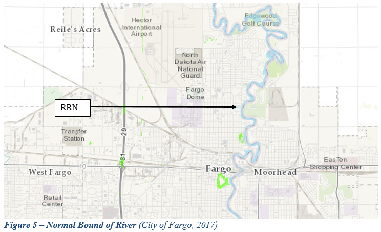
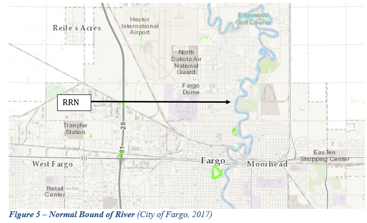
| 20:00, 6 June 2017 | Figure 5.PNG (file) |  |
422 KB | Gtbrien | 3 | |
| 19:47, 6 June 2017 | TEST.PNG (file) |  |
423 KB | Gtbrien | 1 | |
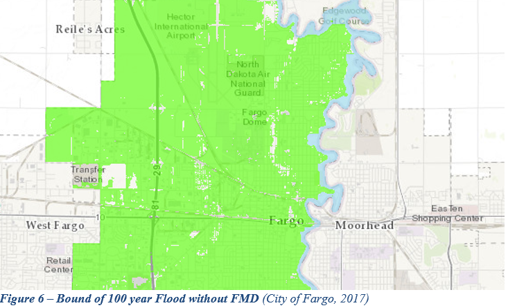
| 20:01, 6 June 2017 | Figure 6.PNG (file) |  |
431 KB | Gtbrien | 3 | |
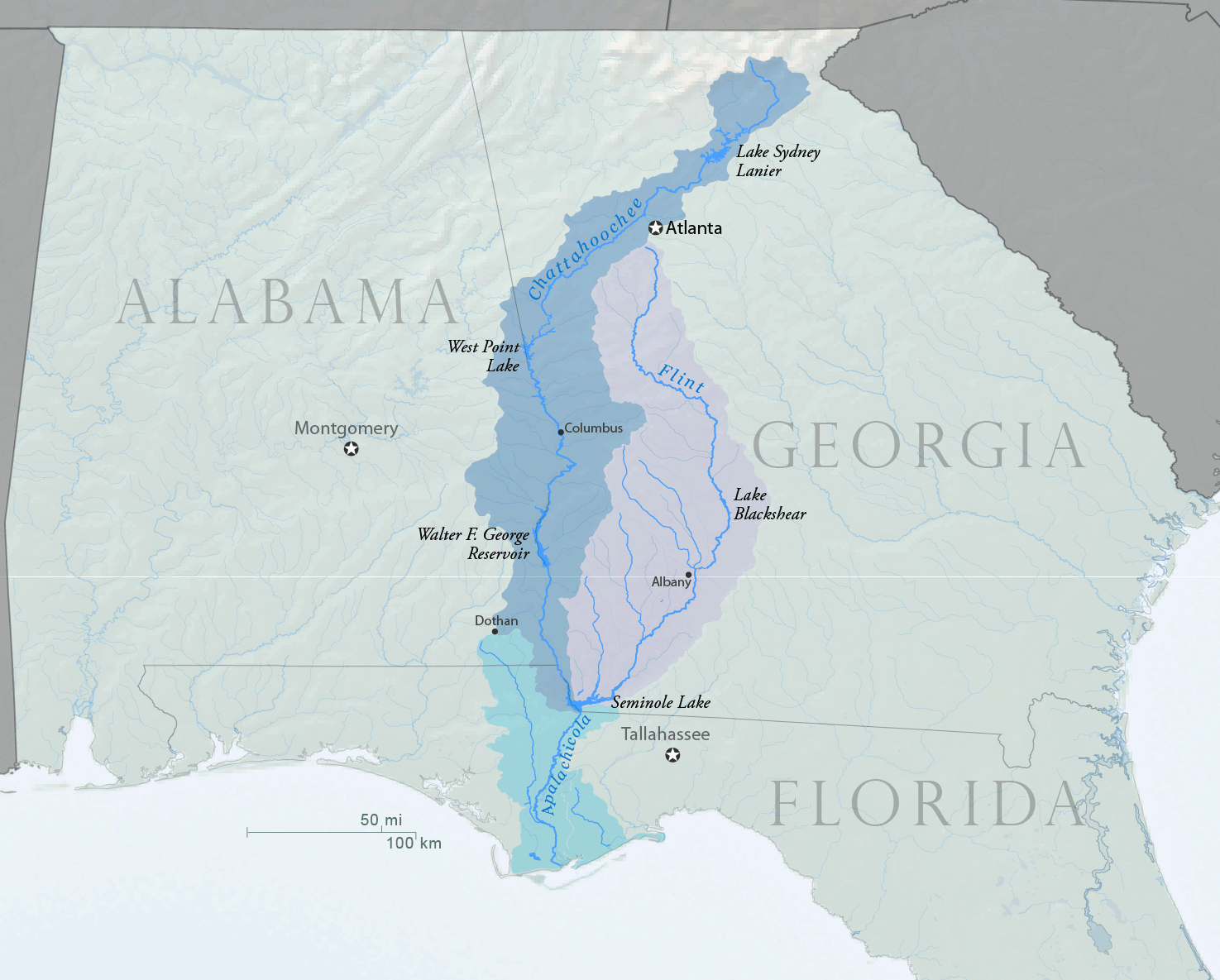
| 11:39, 10 October 2013 | ACF-overview.png (file) |  |
431 KB | Amanda | Map overview showing ACF (Apalachicola-Chattahoochee-Flint) Basin and major reservoirs within the basin. Created by Water Diplomacy using USGS and U.S. Census Bureau Data sources in October 2013. | 1 |
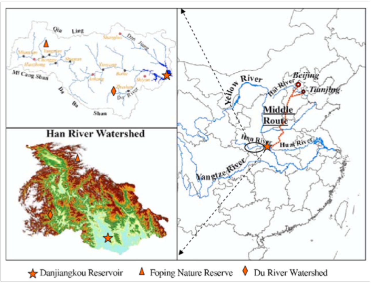
| 08:21, 6 June 2012 | River project watershed Zhang2009.jpg (file) |  |
456 KB | Amanda | Image from: Zhang, Q., Xu, Z., Shen, Z., Li, S. & Wang, S. The Han River watershed management initiative for the South-to-North water transfer project (Middle Route) of China. ''Environmental monitoring and assessment'' 148, 369–377 (2009). Used to des | 1 |
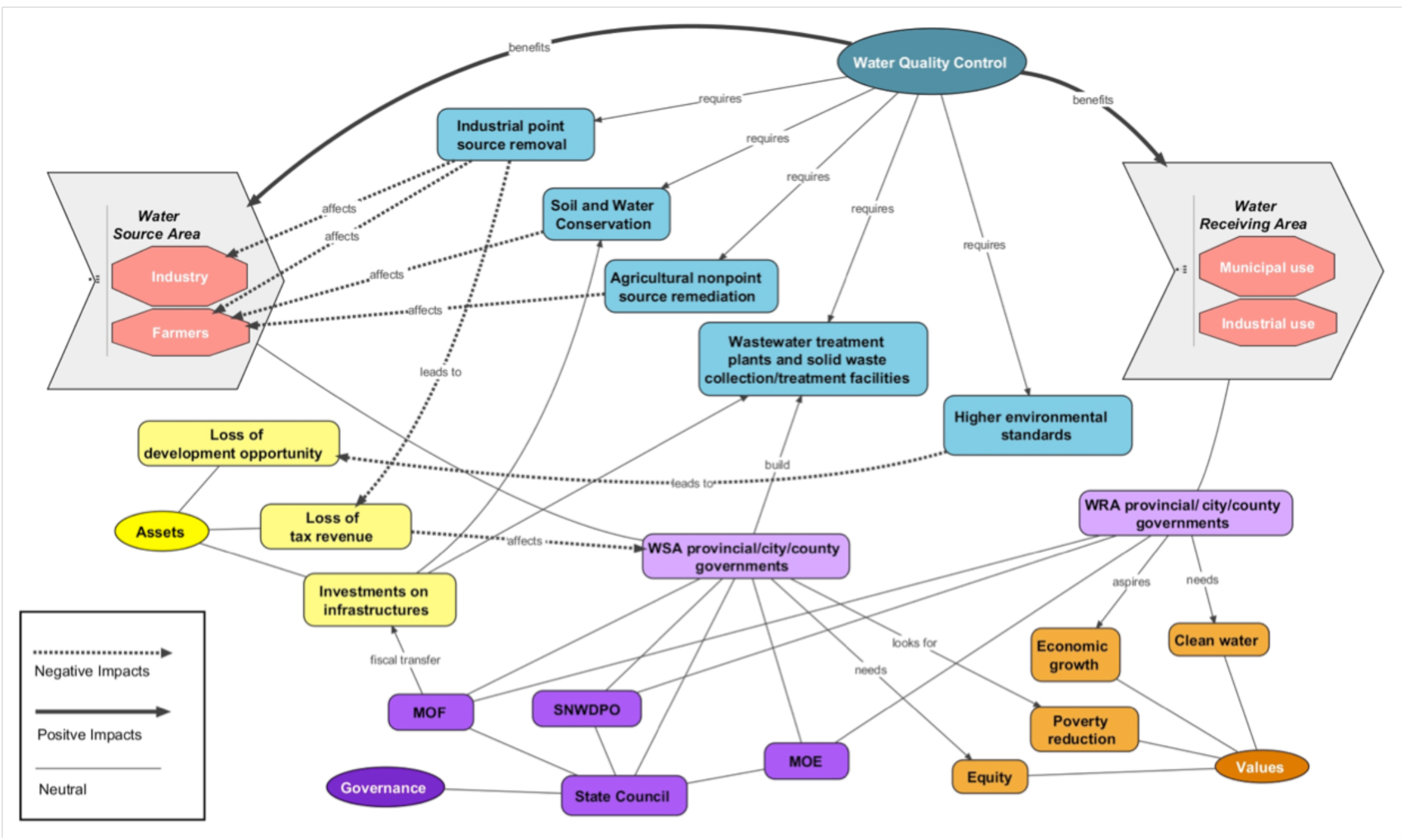
| 08:14, 6 June 2012 | Deangelis and Wang Network MRP 2012.jpg (file) |  |
460 KB | Amanda | A Network Representation Diagram for Water Quality Control on South-to-North Water Diversion (SNWD) Middle Route Project (MRP) Case Study (2012). Yuan Wang and Kelly DeAngelis. Created May 2012. Prepared for Water Diplomacy Seminar III at Tufts Universi | 1 |
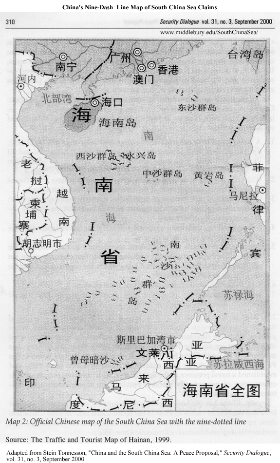
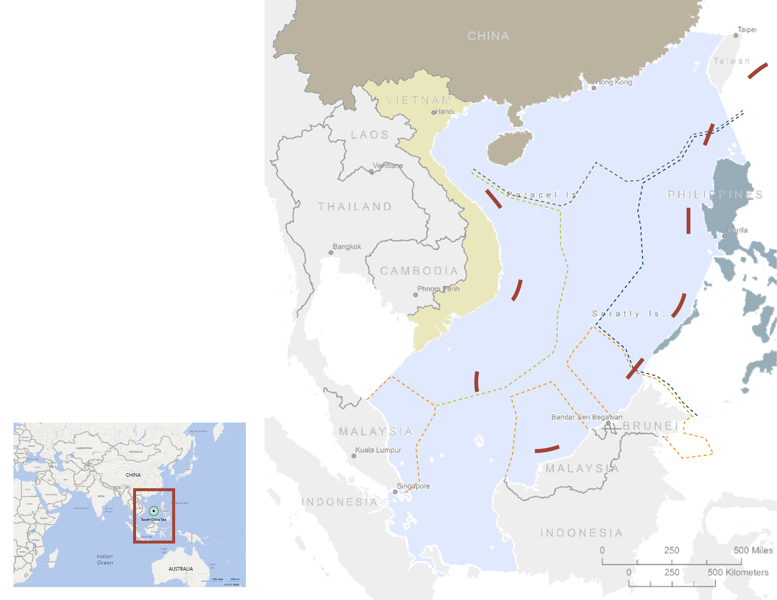
| 10:38, 25 May 2017 | -MAP-03 SouthChinaSea Nine dash line historical map-.gif (file) |  |
463 KB | Pjular | 1 | |
| 10:40, 25 May 2017 | -MAP-06 SouthChinaSea Oil and Natural Gas Platform-.jpg (file) |  |
487 KB | Pjular | 1 | |
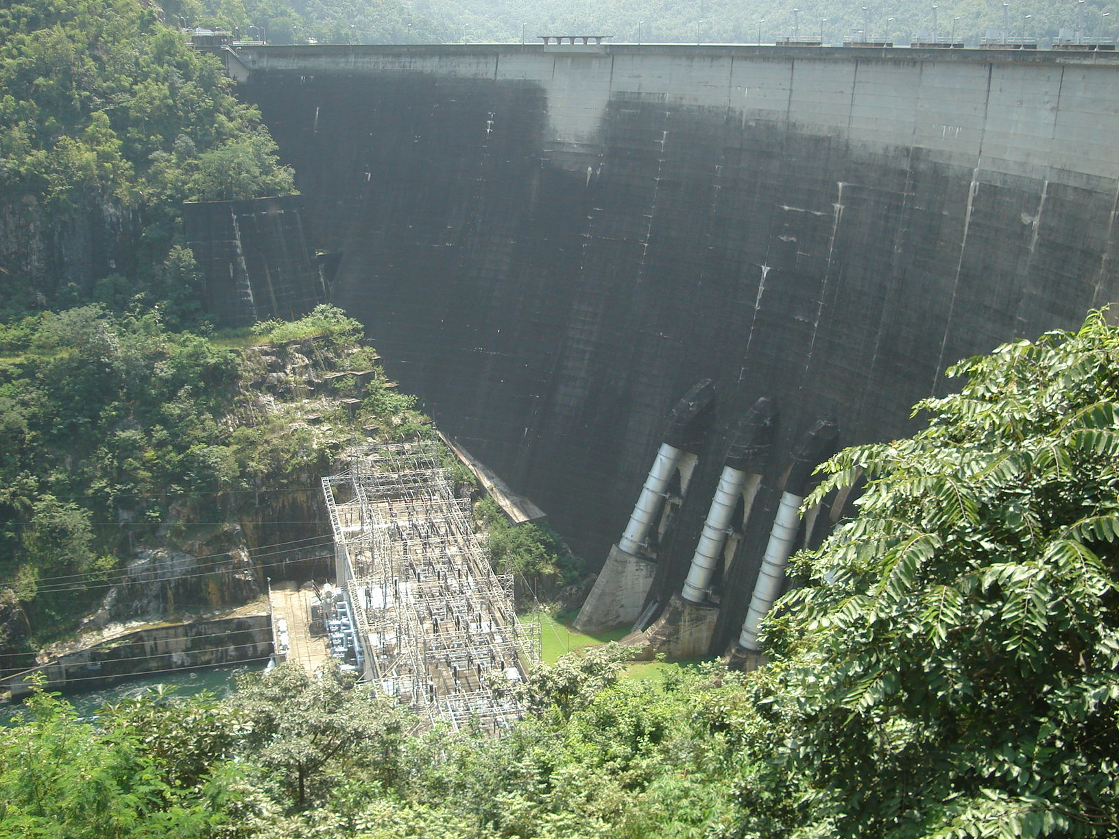
| 21:03, 30 April 2014 | Bhumibol dam front.jpg (file) |  |
490 KB | TSP | Exhibit 3: Bhumipol Dam Source: http://en.wikipedia.org/wiki/Bhumibol_Dam | 1 |
| 16:30, 7 January 2013 | Aquapedia-screenshot-explain-tabs-links.png (file) |  |
492 KB | Amanda | An explanation of navigation tabs for cases and overall navigation via annotated screenshot. CC by SA 3.0 | 2 |
| 13:23, 13 June 2012 | Murillo rafferty ilisu network.png (file) |  |
503 KB | Amanda | Network respresentation of issues/stakeholders for analysis of the Ilisu Dam Project in Turkey by Maria E. Martinez Murillo C. and Mark Rafferty Originally prepared in conjunction with WD III Seminar (Tufts University) course requirements. | 1 |
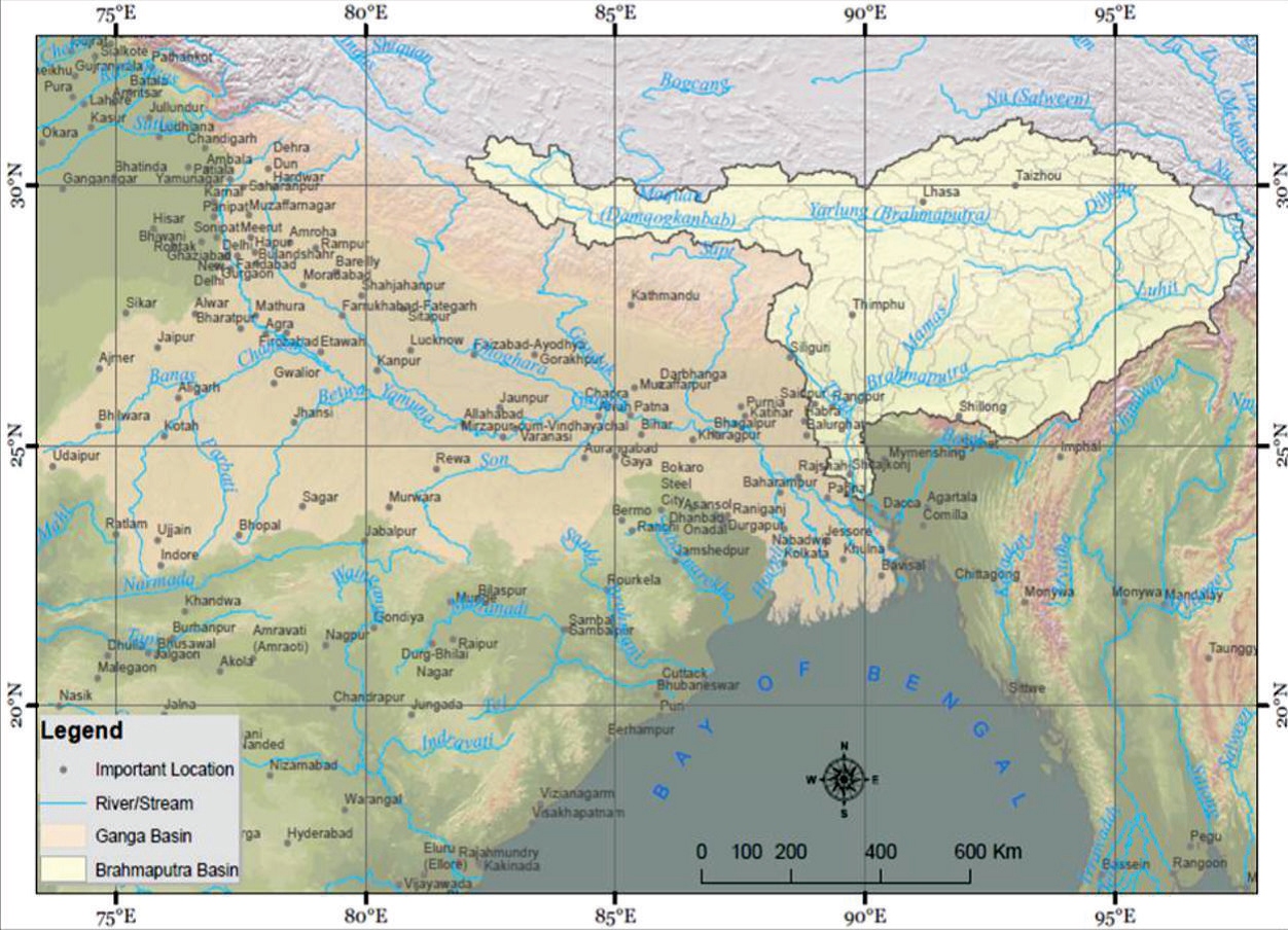
| 16:16, 23 May 2017 | Fig 1. The Brahmaputra sub-basin in South Asia.jpg (file) |  |
536 KB | Cindynoe | 1 | |
| 10:30, 25 May 2017 | -MAP-02 SouthChinaSea Nine dash line claim-.jpg (file) |  |
544 KB | Pjular | 1 | |
| 14:54, 5 June 2017 | Timetable22017-06-05 14.44.31.jpg (file) |  |
564 KB | Jimena SG | 1 | |
| 19:59, 6 June 2017 | Figure 3.PNG (file) |  |
565 KB | Gtbrien | 3 | |
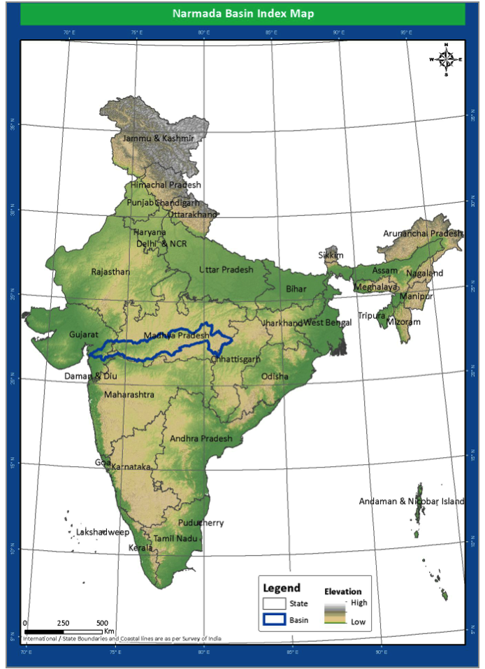
| 21:41, 23 May 2014 | Location.png (file) |  |
567 KB | Rachel | Location of the Narmada River Basin | 1 |
| 14:09, 5 June 2017 | Timetable 2017-06-05 14.03.22.jpg (file) |  |
579 KB | Jimena SG | 1 | |
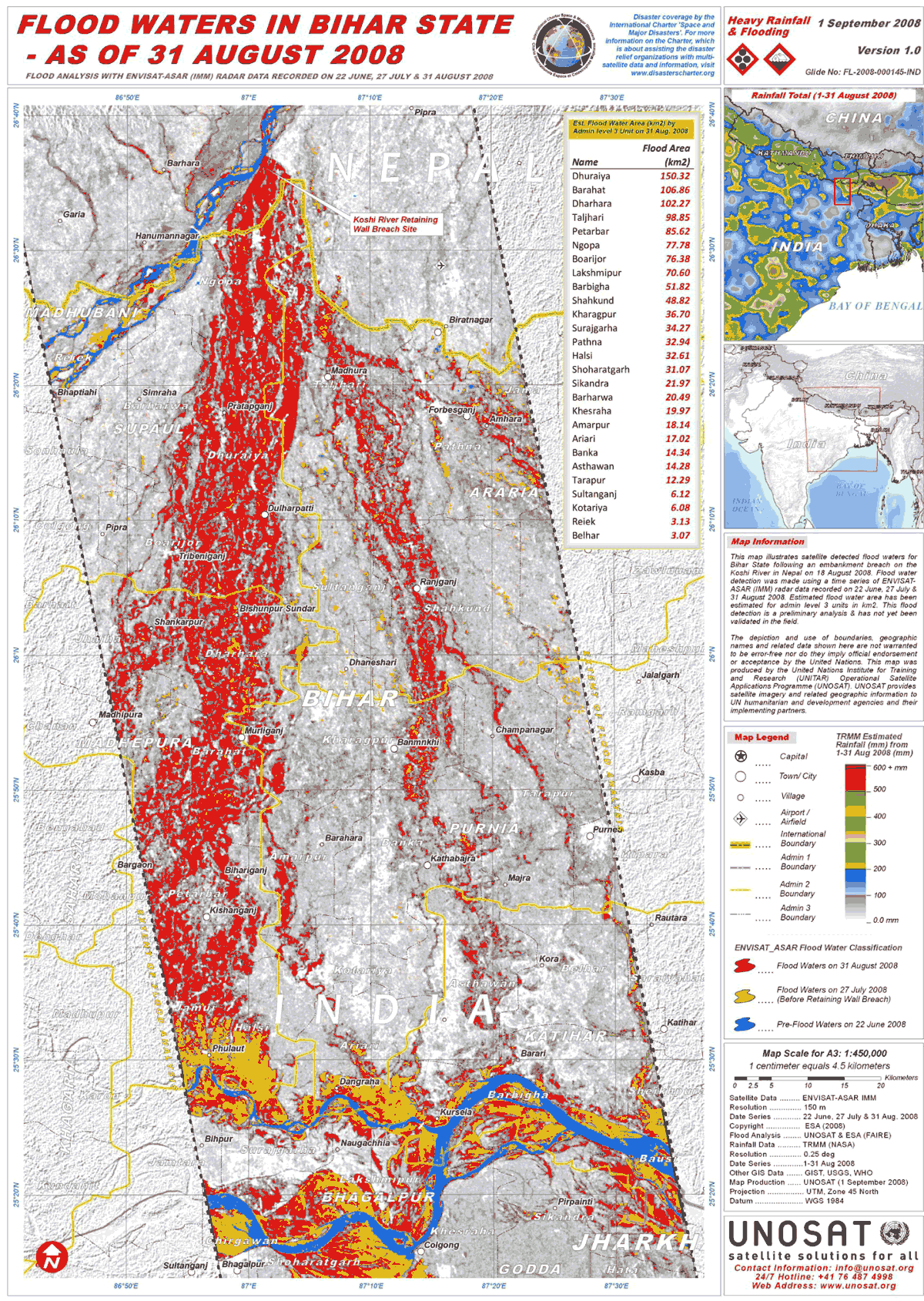
| 17:03, 25 June 2013 | UNOSAT IND Bihar Floods ASAR 31Aug08 Lowres.png (file) |  |
595 KB | Amanda | high-res .pdf available online: http://www.unitar.org/unosat/node/44/1259 Product ID: 1259 - English Published: 1 Sep, 2008 GLIDE: FL-2008-000145-IND “This map illustrates satellite detected flood waters for Bihar State following an embankment brea... | 1 |
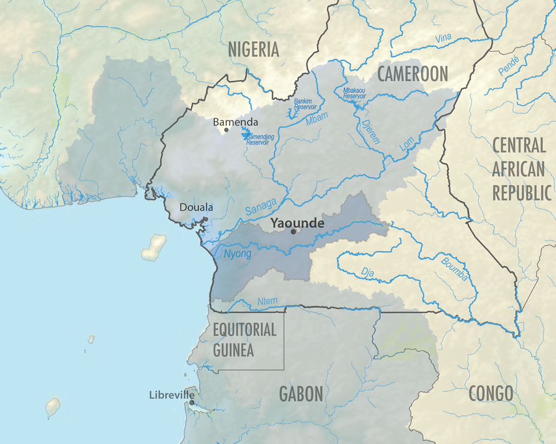
| 11:10, 24 September 2013 | Nyong-GulfofGuinea-Cameroon.png (file) |  |
619 KB | Amanda | The Nyong River Basin in Cameroon is one of the basins of Cameroon that drains to the Gulf of Guinea. This map was produced by Water Diplomacy for the AquaPedia Case Study Database. Data Sources: GADM v2.0 (Administrative Boundaries) and FAO AQUASTAT... | 1 |
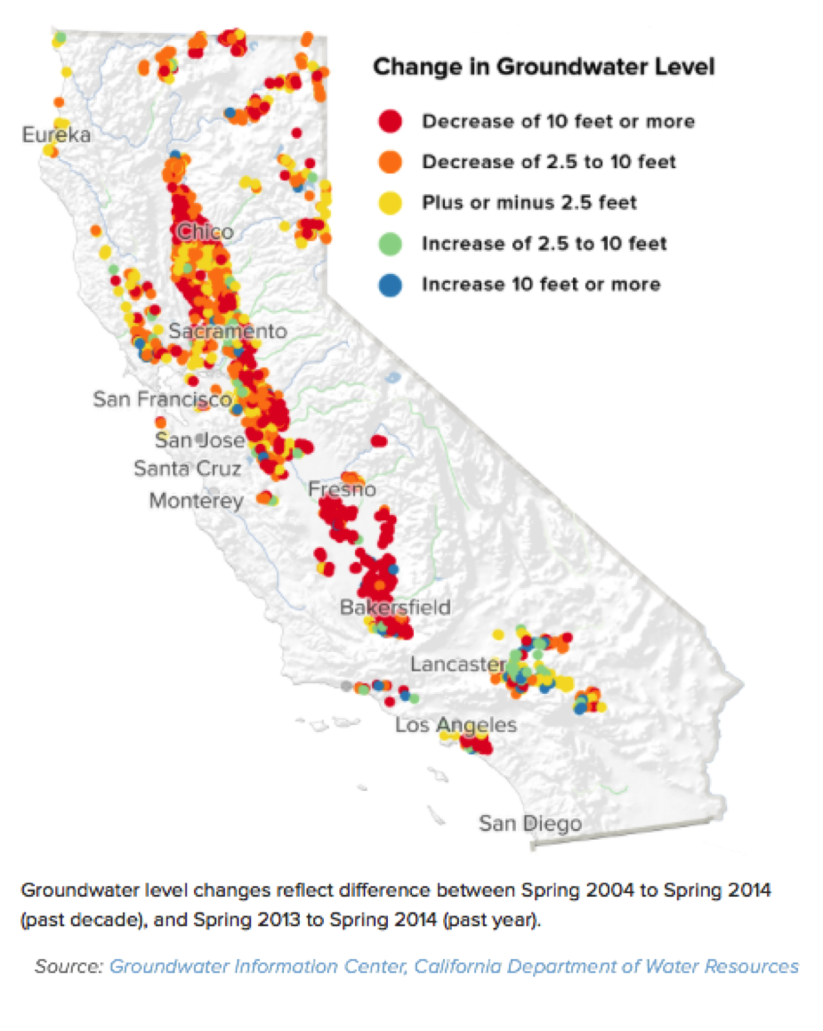
| 09:57, 1 November 2017 | Sal2.png (file) |  |
620 KB | SamKumasaka | Change in Groundwater Level 2004-2014 Groundwater Information Center, CA Department of Water Resources | 1 |
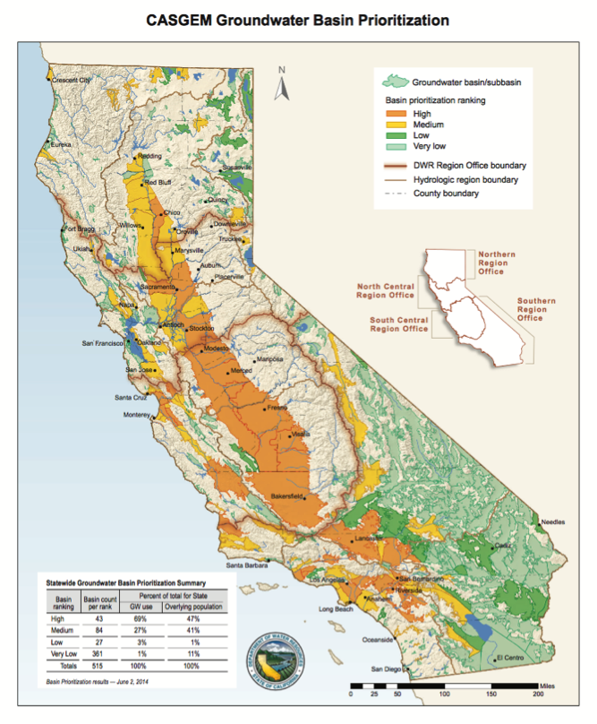
| 09:59, 1 November 2017 | Sal3.png (file) |  |
626 KB | SamKumasaka | CASGEM Groundwater Basin Prioritization | 1 |
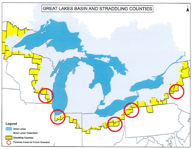
| 19:16, 21 May 2014 | US Straddling Counties.png (file) |  |
648 KB | B Finney | This image was taken from a presentation by the Waukesha Water Utility: http://www.ci.waukesha.wi.us/c/document_library/get_file?uuid=7480f775-3981-46a7-a7c0-c1f8579227b1&groupId=10113 | 1 |
| 10:39, 25 May 2017 | -MAP-05 SouthChinaSea Crude oil trade flow-.jpg (file) |  |
671 KB | Pjular | 1 | |
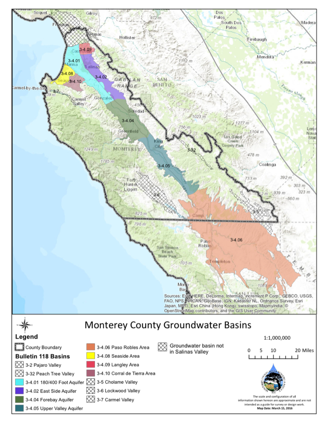
| 10:04, 1 November 2017 | Sal4.png (file) |  |
697 KB | SamKumasaka | Monterey County Groundwater Sub-basins | 1 |
| 14:09, 16 May 2013 | Coloradorivermapnew1.jpg (file) |  |
701 KB | Amanda | Author: Wikimedia Commons user Shannon [GFDL (http://www.gnu.org/copyleft/fdl.html) or CC-BY-SA-3.0-2.5-2.0-1.0 (http://creativecommons.org/licenses/by-sa/3.0)], via Wikimedia Commons Background and river course data from http://www2.demis.nl/mapserver/m | 1 |
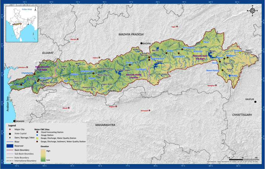
| 21:42, 23 May 2014 | Drainage.png (file) |  |
720 KB | Rachel | Narmada Basin and Sub-basin Drainage, incl. Reservoirs (submergence areas) | 1 |
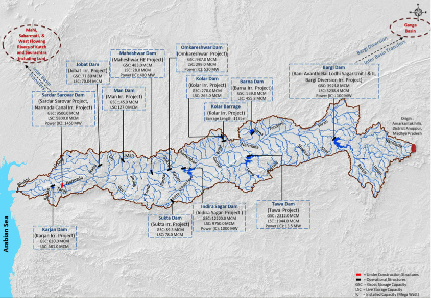
| 21:41, 23 May 2014 | Major projects.png (file) |  |
837 KB | Rachel | Major Water Resource Projects in the Narmada Basin | 1 |
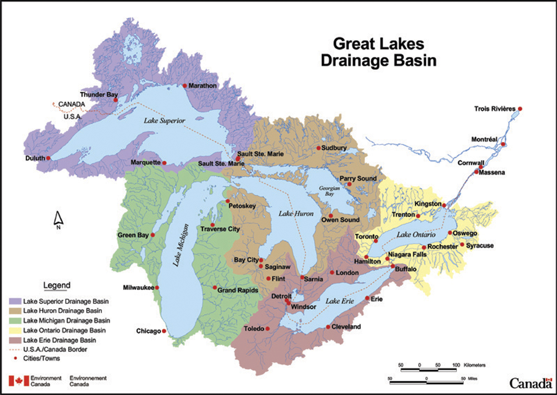
| 11:44, 16 May 2014 | Great Lakes Drainage Basin Env Canada.jpg (file) |  |
852 KB | Amanda | This map depicts the sub-basins within the Great Lakes drainage basin. This is a reproduction of a map produced by Environment Canada. It is a copy of an official work that is published by the Government of Canada and that the reproduction has not bee... | 1 |
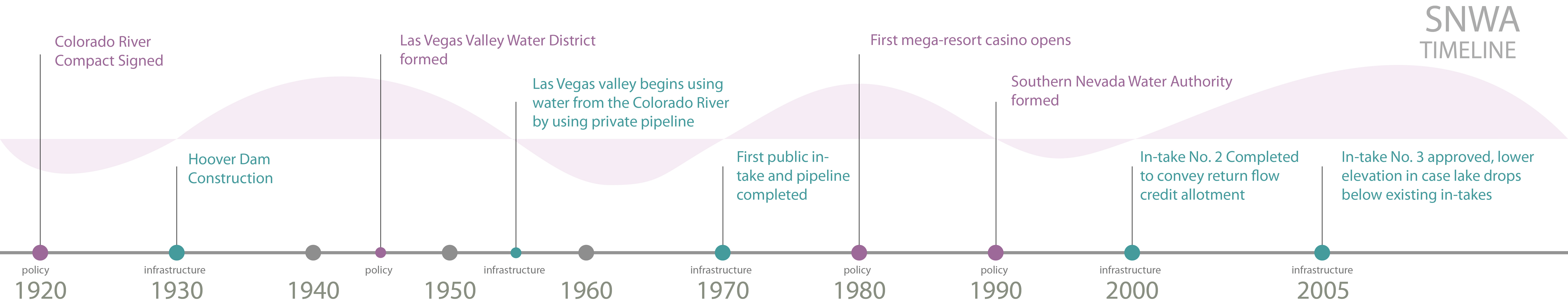
| 15:02, 14 May 2013 | SNWA Timeline 1920 - 2005.jpg (file) | 857 KB | Amanda | Produced by Margaret Garcia for Water Competition & Cooperation in the Las Vegas Valley | 1 | |
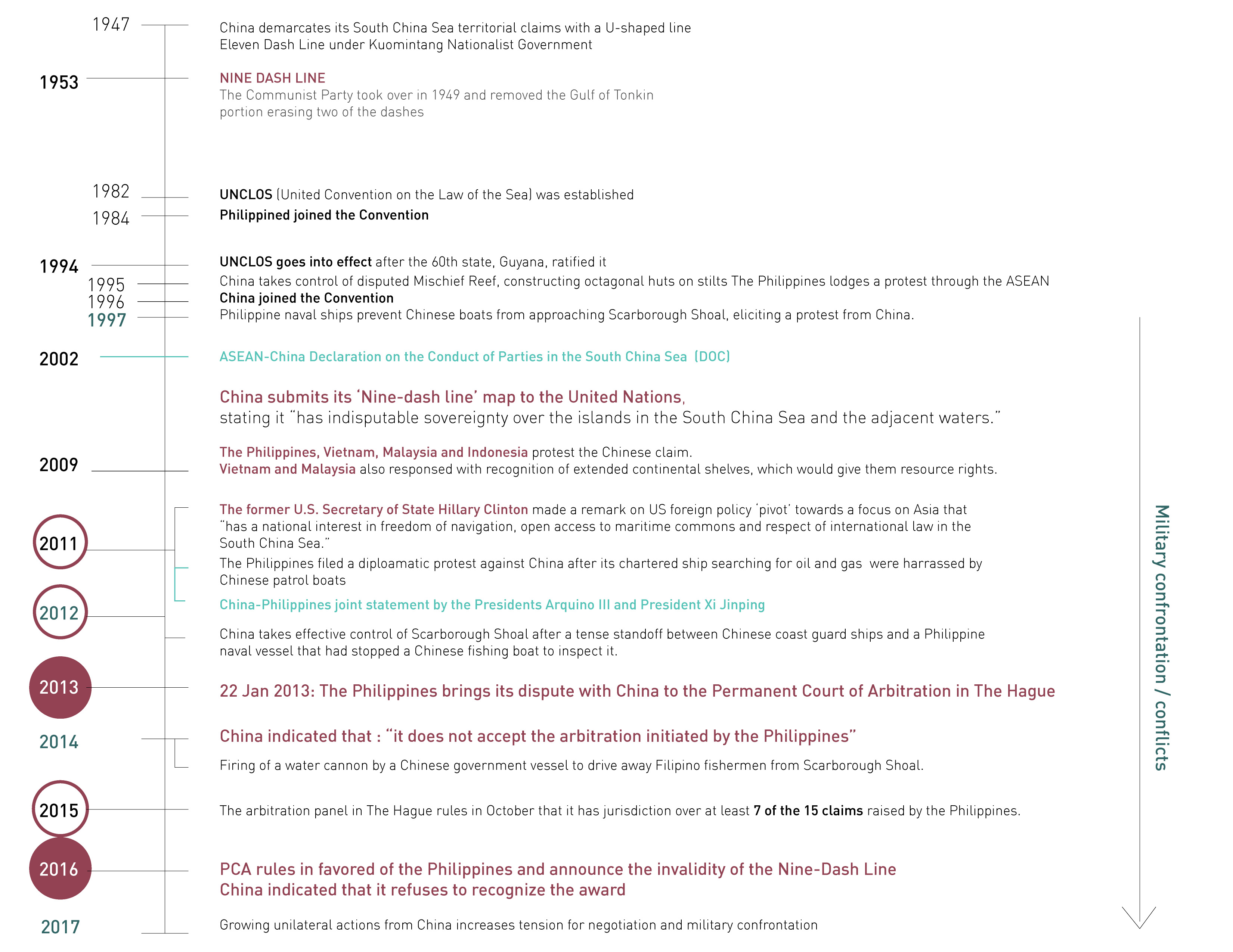
| 10:41, 25 May 2017 | -Timeline01 SouthChinaSea ChinavsPhilippines-.jpg (file) |  |
874 KB | Pjular | 1 | |
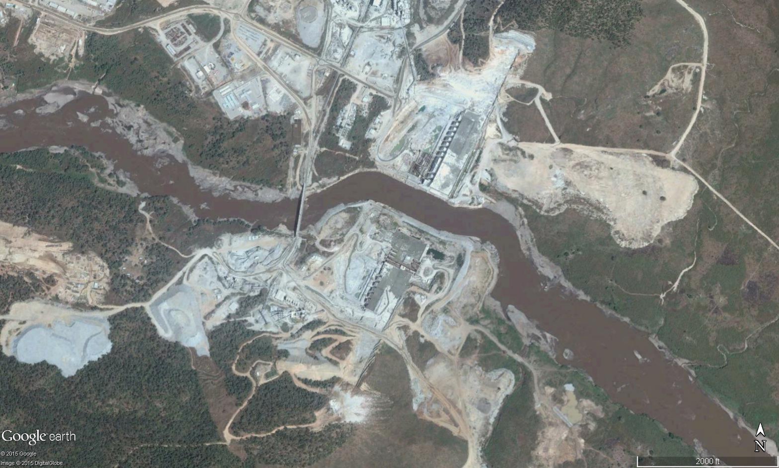
| 16:26, 21 December 2015 | GERD Site.jpg (file) |  |
895 KB | Agustinbotteron | Site of construction of the Grand Ethiopian Renaissance Dam (GERD), Ethiopia. | 1 |
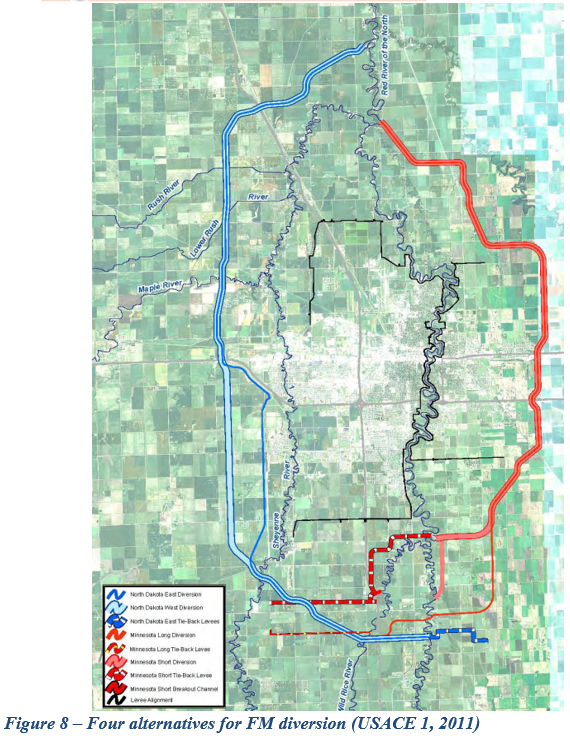
| 20:02, 6 June 2017 | Figure 8.PNG (file) |  |
978 KB | Gtbrien | 3 | |
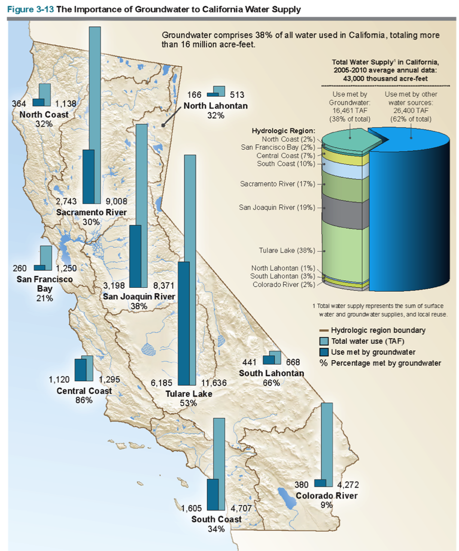
| 10:07, 1 November 2017 | Sal5.png (file) |  |
1.06 MB | SamKumasaka | The Importance of Groundwater to California Water Supply Groundwater comprises 38% of all water used in California, totaling more than 16 million acre-feet. Source: CA DWR | 1 |
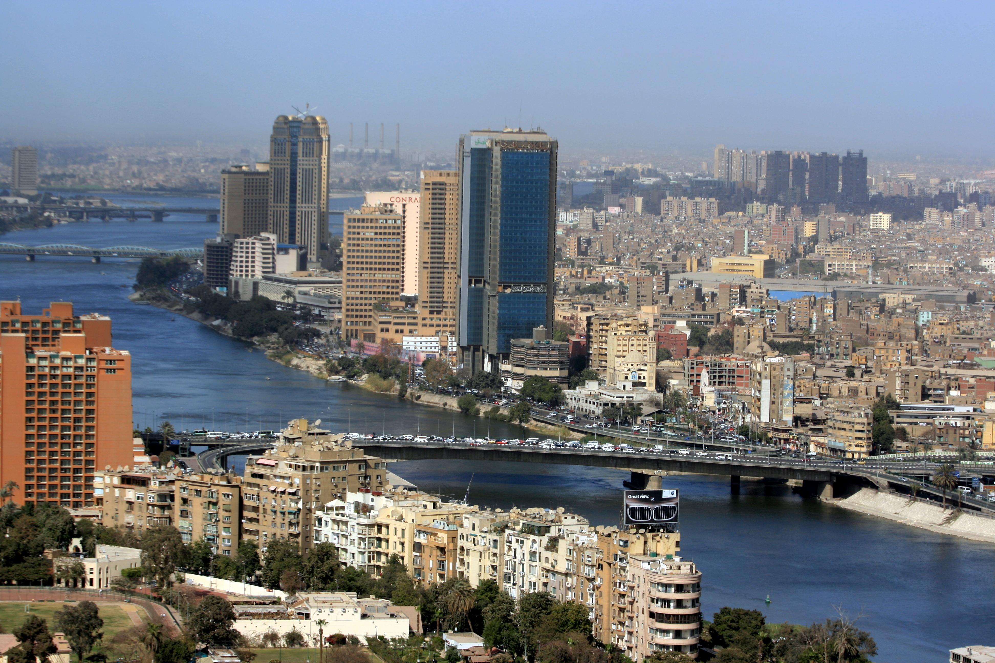
| 17:28, 21 December 2015 | Cairo02.jpg (file) |  |
1.18 MB | Agustinbotteron | 1 | |
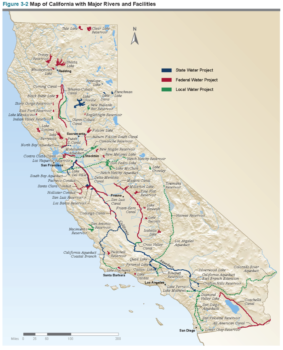
| 17:43, 31 October 2017 | CaliforniaWater.png (file) |  |
1.19 MB | SamKumasaka | A map of California with major waterways from the California Water Plan | 1 |
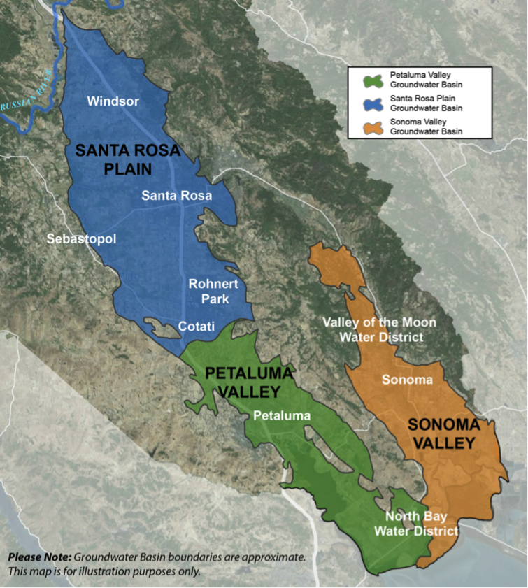
| 10:18, 1 November 2017 | SonomaBasins.png (file) |  |
1.2 MB | SamKumasaka | The three groundwater basins in Sonoma County designated medium-priority: Santa Rosa Plain, Petaluma Valley, and Sonoma Valley Basins Source: CASGEM | 1 |
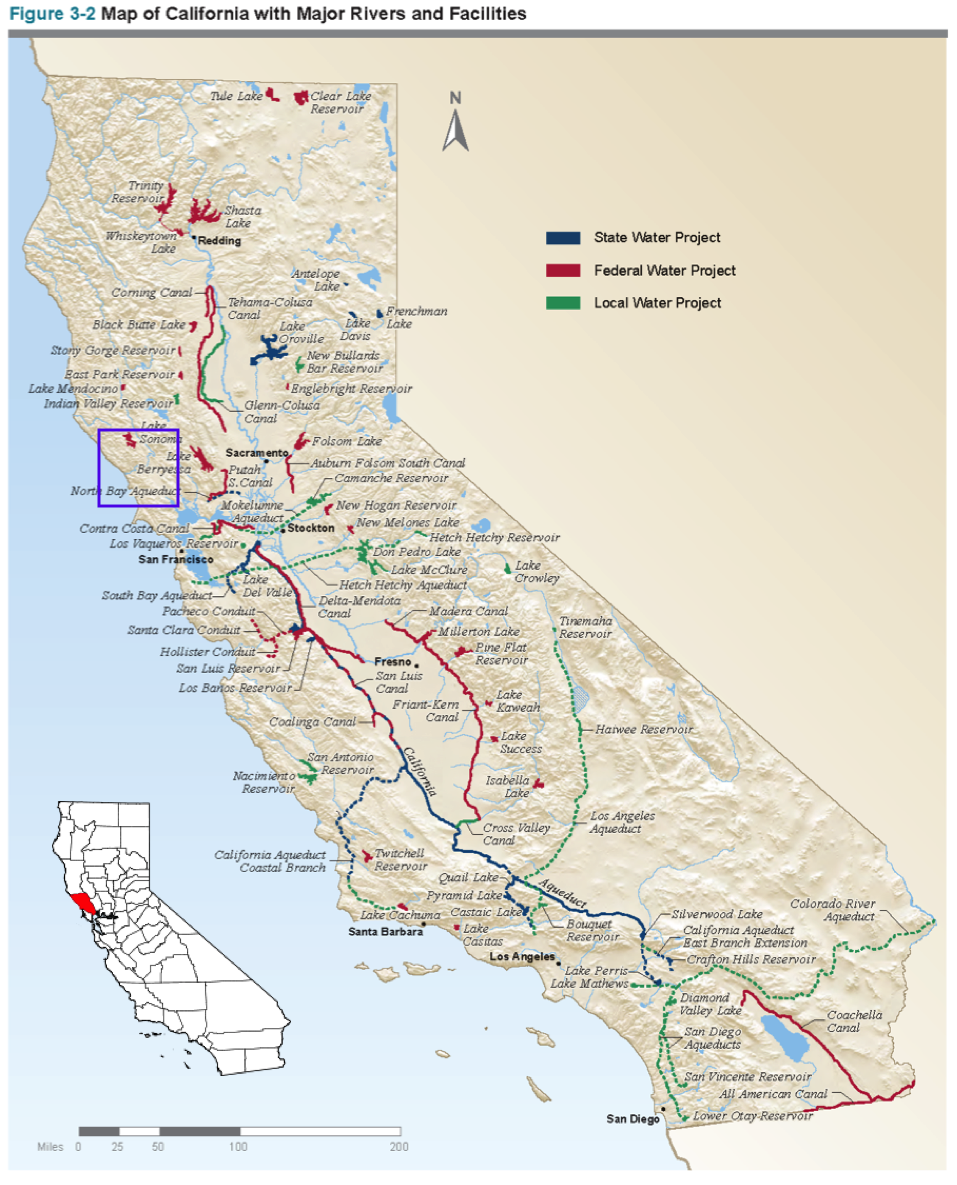
| 13:28, 13 November 2017 | CASalinas.png (file) |  |
1.22 MB | SamKumasaka | Map of water projects in California from the California Water Project with Salinas County highlighted. | 1 |
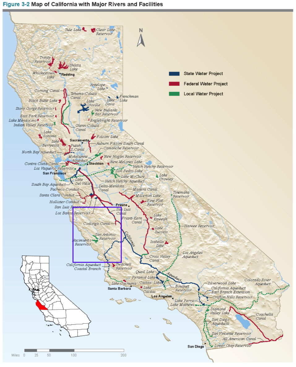
| 13:23, 13 November 2017 | CASonoma.png (file) |  |
1.23 MB | SamKumasaka | Map of California Water Projects and Sonoma County | 1 |
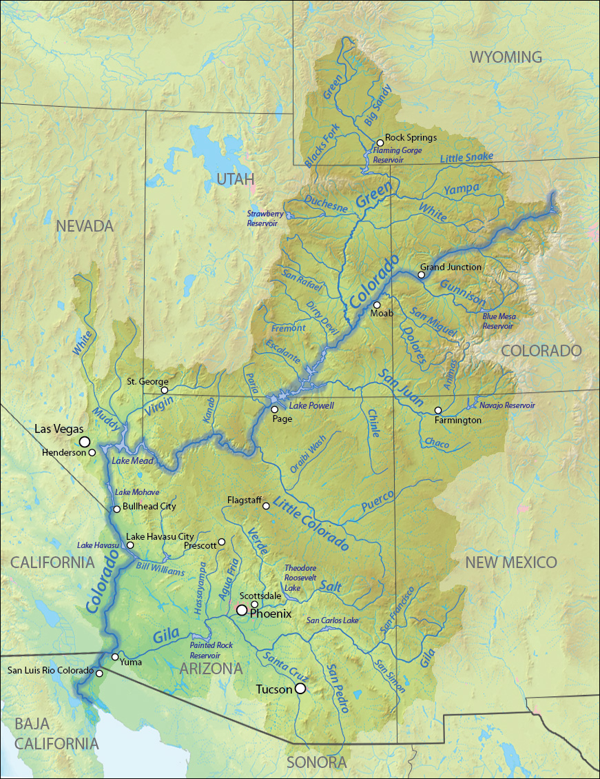
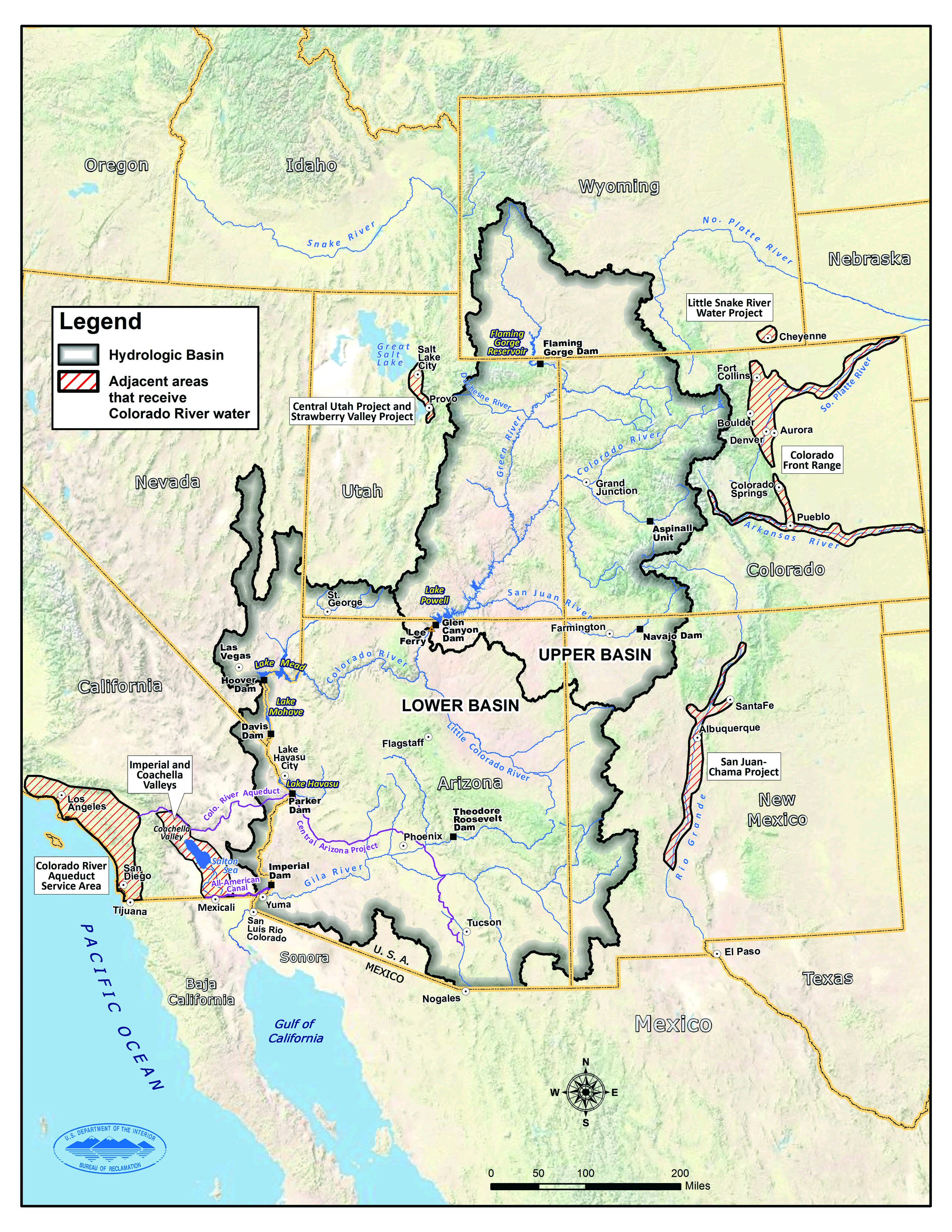
| 10:19, 25 May 2017 | Map coloradoriverbasin.jpg (file) |  |
1.37 MB | Keefe | Source: https://www.usbr.gov/lc/region/programs/crbstudy.html | 1 |
| 10:15, 25 May 2017 | Map.jpg (file) |  |
1.37 MB | Keefe | Source: https://www.usbr.gov/lc/region/programs/crbstudy.html | 1 |
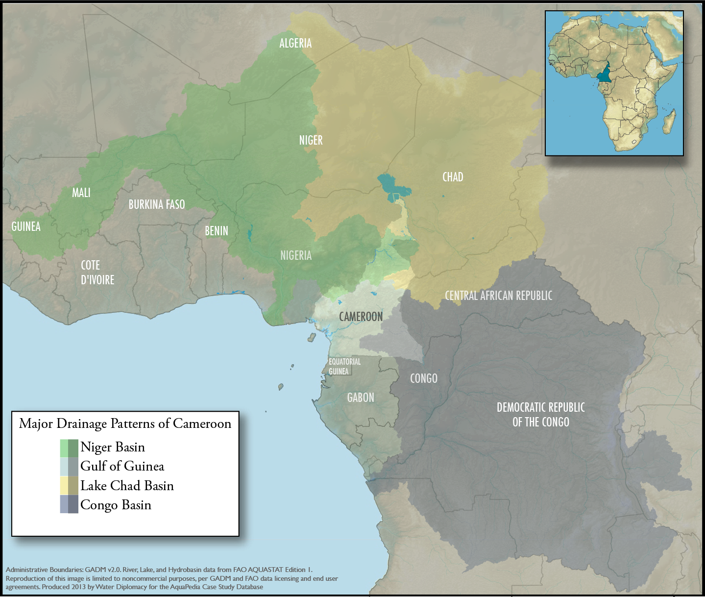
| 15:48, 23 September 2013 | Cameroon-regional-overview.png (file) |  |
1.43 MB | Amanda | An overview map showing Cameroon within the context of the 4 major drainage patterns: Niger Basin, Lake Chad, Congo Basin, and Gulf of Guinea. Produced by Water Diplomacy for Cameroon-related articles Data Sources: GADM v2.0 (Administrative Boundarie... | 1 |
| 14:34, 31 July 2014 | Buesser, Christine - Gaza Water Management Presentation MIT May 2014 external use.pdf (file) | 1.61 MB | Amanda | Slides from a presentation by Christine Buesser, at MIT for the 2014 Spring Semester Water Diplomacy course, May 15, 2014 Images within the presentation are subject to the copyright of their original source. This file is included here because it i... | 1 | |
| 17:07, 18 January 2016 | Aerial1.jpg (file) |  |
1.89 MB | JRozek | Source: https://www.flickr.com/photos/nasa2explore/14943033928 License: https://creativecommons.org/licenses/by-nc/2.0/ | 1 |
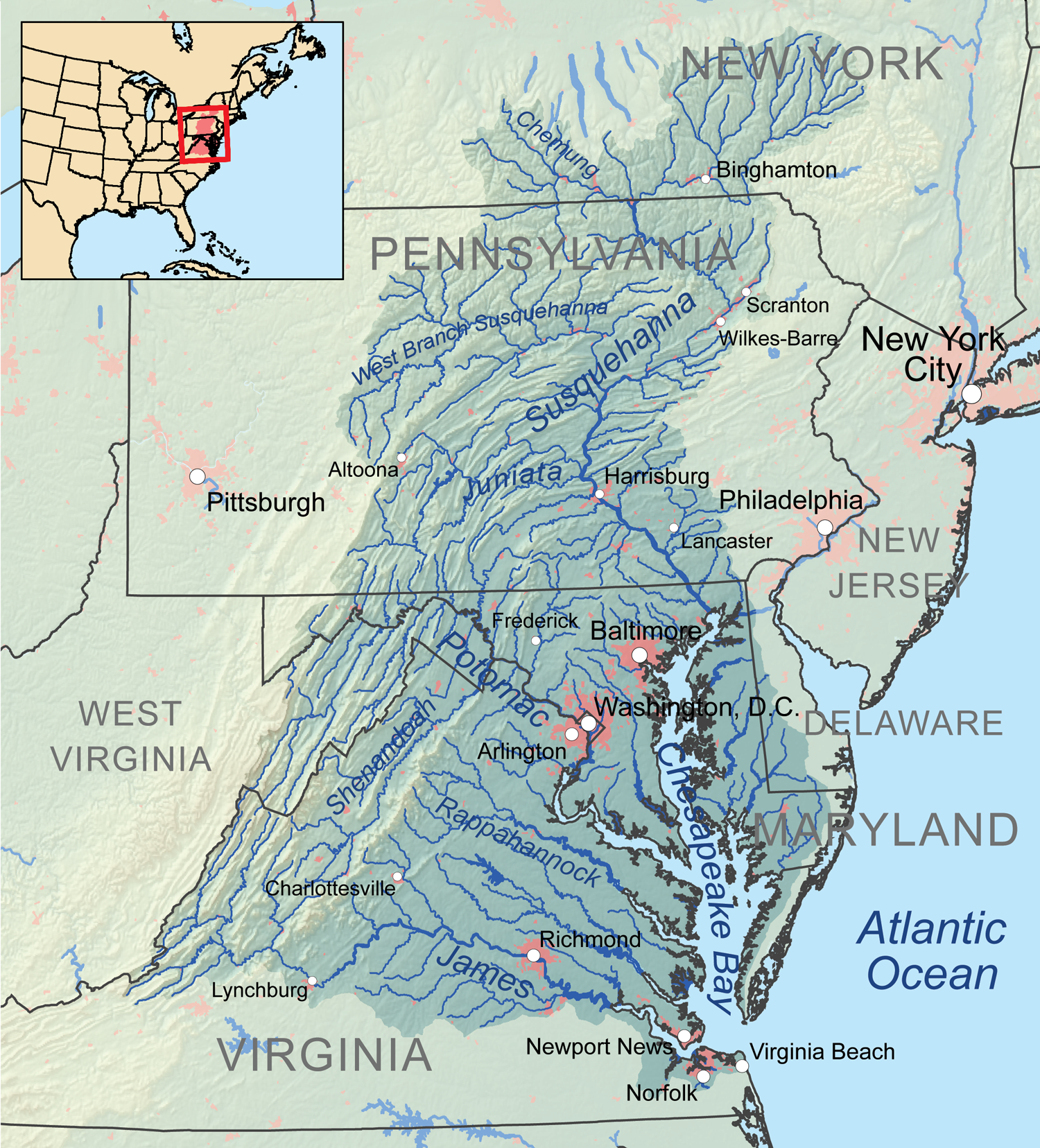
| 22:30, 15 May 2017 | Chesapeakewatershedmap.png (file) |  |
2.79 MB | Ncohen | Map of the Chesapeake Bay Watershed | 1 |
| 08:09, 30 January 2015 | Hydro-diplomacy to Address the Transboundary Water Issues between India and Pakistan.pdf (file) | 3.1 MB | Ashfaqm | PDF slide version of presentation: Mahmoud, A. 2014. Hydro-diplomacy to Address the Transboundary Water Issues between India and Pakistan Presentation from IUCN 2nd National Consultative Workshop on Pakistan Water Issues (3 June 2014) Available from:... | 1 | |
| 07:32, 26 October 2014 | Nile GERD AHD hydrology.pdf (file) | 3.2 MB | Tesfay | Recently published Modeling of two cascade and cross-border dams; the impact of the Grand Ethiopian Renascence Dam on the Egyptian Aswan Dam. An article focused on the Nile basin water management. | 1 | |
| 20:51, 7 January 2014 | Lebanon Aquapedia Research Lebanon TYates.docx (file) | 3.7 MB | Tmyates | 1 | ||
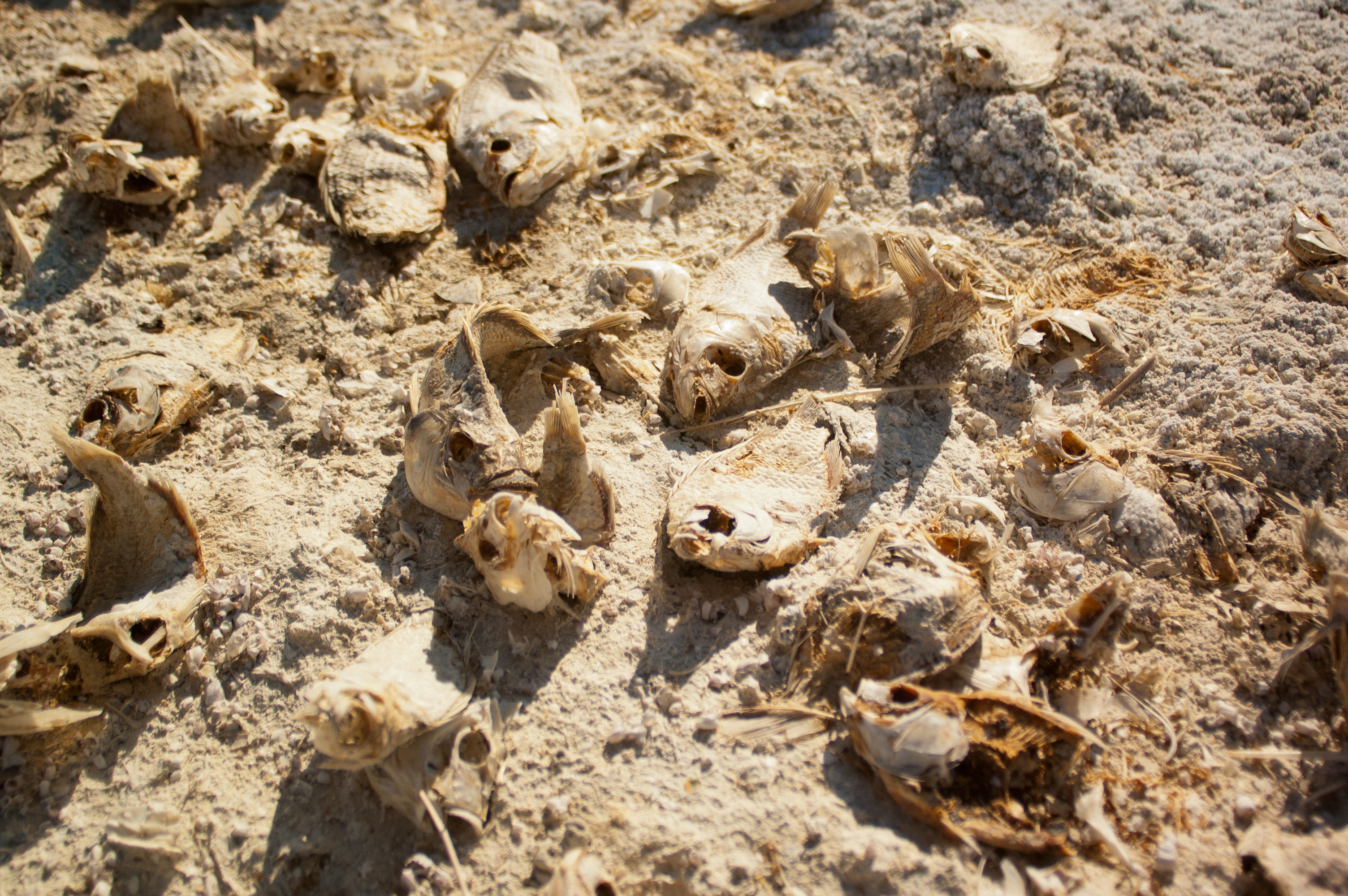
| 17:02, 18 January 2016 | DeadFish.jpg (file) |  |
5.02 MB | JRozek | Source: https://www.flickr.com/photos/hermitsmoores/6578846137/ License: https://creativecommons.org/licenses/by-nc-sa/2.0/ | 1 |
| 17:17, 21 December 2015 | Ethiopia Highlands.jpg (file) |  |
8.05 MB | Agustinbotteron | 1 | |
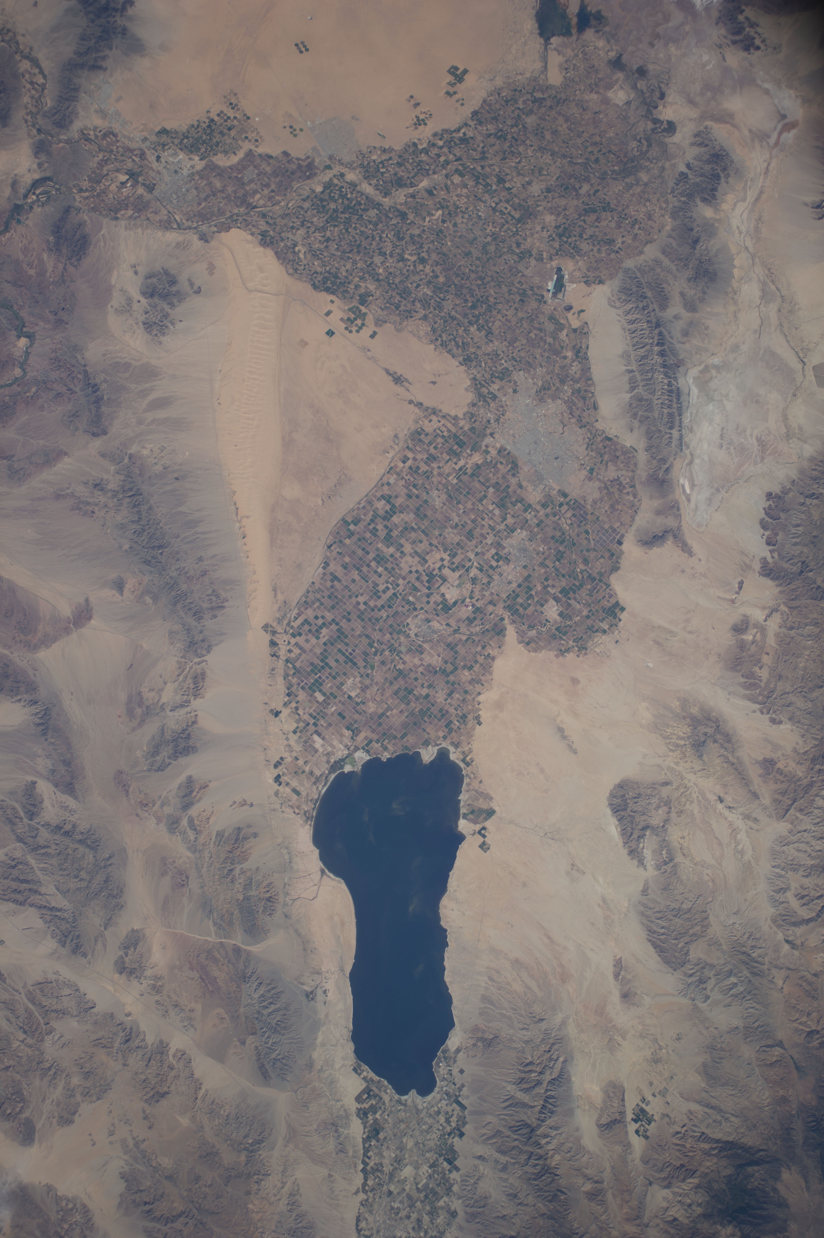
| 16:58, 18 January 2016 | Salton Pano.jpg (file) | 9.11 MB | JRozek | Source: https://www.flickr.com/photos/on_earth/14523087446 License: https://creativecommons.org/licenses/by/2.0/ | 1 |
First page |
Previous page |
Next page |
Last page |


