File list
This special page shows all uploaded files.
| Name | Thumbnail | Size | User | Description | Versions | |
|---|---|---|---|---|---|---|
| 12:57, 14 May 2014 | Abstract.docx (file) | 13 KB | Jcheung6 | 1 | ||
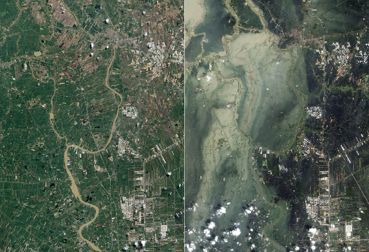
| 13:12, 12 May 2014 | Exhibit3-BfAf-Flooding-640x480.jpg (file) |  |
154 KB | TSP | Exhibit 3: Satellite photographs showing flooding in Ayutthaya and Pathum Thani Provinces in July 2011 (left, before the flooding) and October 2011 (right, after the flooding) Source: http://en.wikipedia.org/wiki/2011_Thailand_floods | 1 |
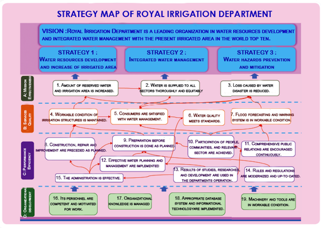
| 13:11, 12 May 2014 | Exhibit2-RID-strategy-map-640x480.png (file) |  |
304 KB | TSP | Exhibit 5b: Strategy Map of Thailand’s Royal Irrigation Department Source: http://www.rid.go.th/ | 1 |
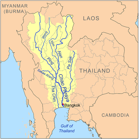
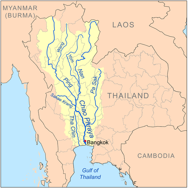
| 13:09, 12 May 2014 | Exhibit1-CPRB-Map-640x480.png (file) |  |
211 KB | TSP | Exhibit 1: The Chao Phraya River and its Tributaries Source: http://en.wikipedia.org/wiki/Tributaries_of_the_Chao_Phraya_River | 1 |
| 22:47, 10 May 2014 | Xx-7.jpg (file) |  |
170 KB | TSP | Satellite photographs showing flooding in Ayutthaya and Pathum Thani Provinces in July 2011 (left, before the flooding October 2011) and October 2011 (right, after the flooding in July) Source: http://en.wikipedia.org/wiki/2011_Thailand_floods | 1 |
| 22:46, 10 May 2014 | 7.jpg (file) |  |
419 KB | TSP | 2011 Thailand Flood Satellite Photo Source: http://en.wikipedia.org/wiki/2011_Thailand_floods | 1 |
| 22:17, 10 May 2014 | Xx-Bhumibol dam front.jpg (file) |  |
132 KB | TSP | Bhumipol Dam Source: http://en.wikipedia.org/wiki/Bhumibol_Dam | 1 |
| 22:10, 10 May 2014 | Xx-Chaophrayarivermapxx.png (file) |  |
233 KB | TSP | The Chao Phraya River and its Tributaries Source: http://en.wikipedia.org/wiki/Tributaries_of_the_Chao_Phraya_River | 1 |
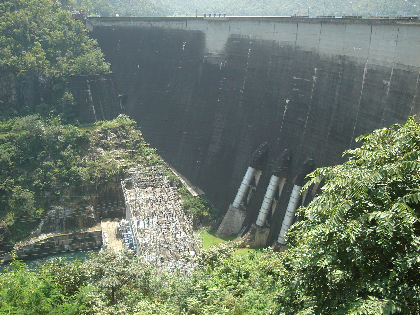
| 21:03, 30 April 2014 | Bhumibol dam front.jpg (file) |  |
490 KB | TSP | Exhibit 3: Bhumipol Dam Source: http://en.wikipedia.org/wiki/Bhumibol_Dam | 1 |
| 21:02, 30 April 2014 | Wat Arun.jpg (file) |  |
42 KB | TSP | Wat Arun, viewed from Chao Phraya River http://en.wikipedia.org/wiki/Chao_Phraya_River | 1 |
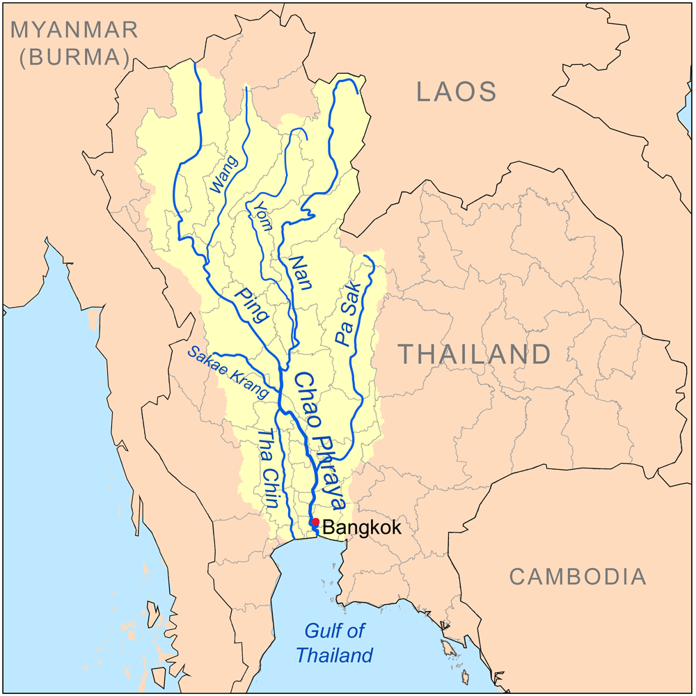
| 21:01, 30 April 2014 | Chaophrayarivermap.png (file) |  |
391 KB | TSP | The Chao Phraya River and its Tributaries Source: http://en.wikipedia.org/wiki/Tributaries_of_the_Chao_Phraya_River | 1 |
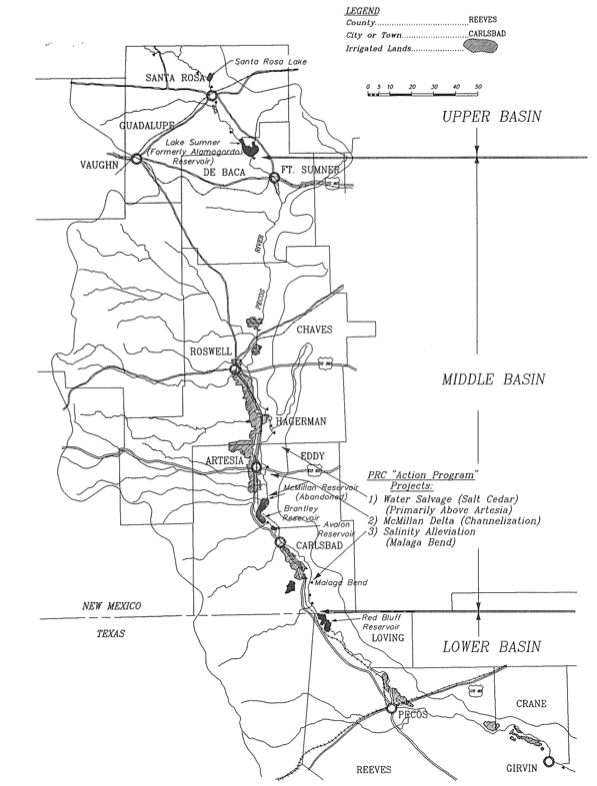
| 19:13, 29 April 2014 | PecosMap.png (file) |  |
163 KB | Mattfitz | A detailed map of the Pecos River Basin in New Mexico from [Kraai, 1993] | 1 |
| 21:27, 28 April 2014 | IRD strategy-map.png (file) |  |
121 KB | TSP | 2 | |
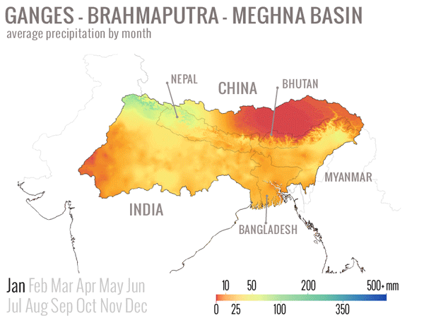
| 08:29, 18 March 2014 | GBM monthly average precip.gif (file) |  |
335 KB | Amanda | animated .GIF illustrating average monthly precipitation values in the Ganges-Brahmaputra-Meghna Basin (India, Nepal, China (Tibet), Bhutan, Bangladesh, Myanmar) Precipiation values from 30 arc-second World Clim global data set. Interpolated average p... | 1 |
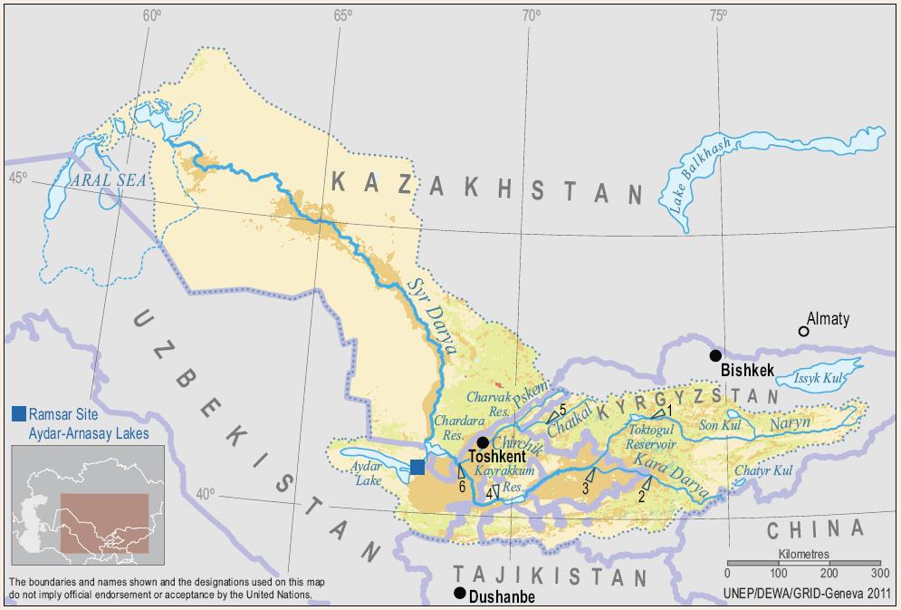
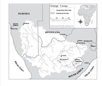
| 15:22, 22 January 2014 | Syr Darya.jpg (file) |  |
86 KB | Gsixt | The Syr Darya and its Major Tributaries | 1 |
| 09:53, 9 January 2014 | Schematic of Govt Water Data Exchange Lebanon UNESCWA.png (file) |  |
39 KB | Amanda | Data Exchange between government water stakeholders in Lebanon (UNESCWA) This figure is from UNESCWA. WATER IN LEBANON STRATEGIC MANAGEMENT DATA NATIONAL ASSESSMENT MATRIX. 2012. Presentation PDF Online at https://unstats.un.org/unsd/envaccounting/wo... | 1 |
| 20:51, 7 January 2014 | Lebanon Aquapedia Research Lebanon TYates.docx (file) | 3.7 MB | Tmyates | 1 | ||
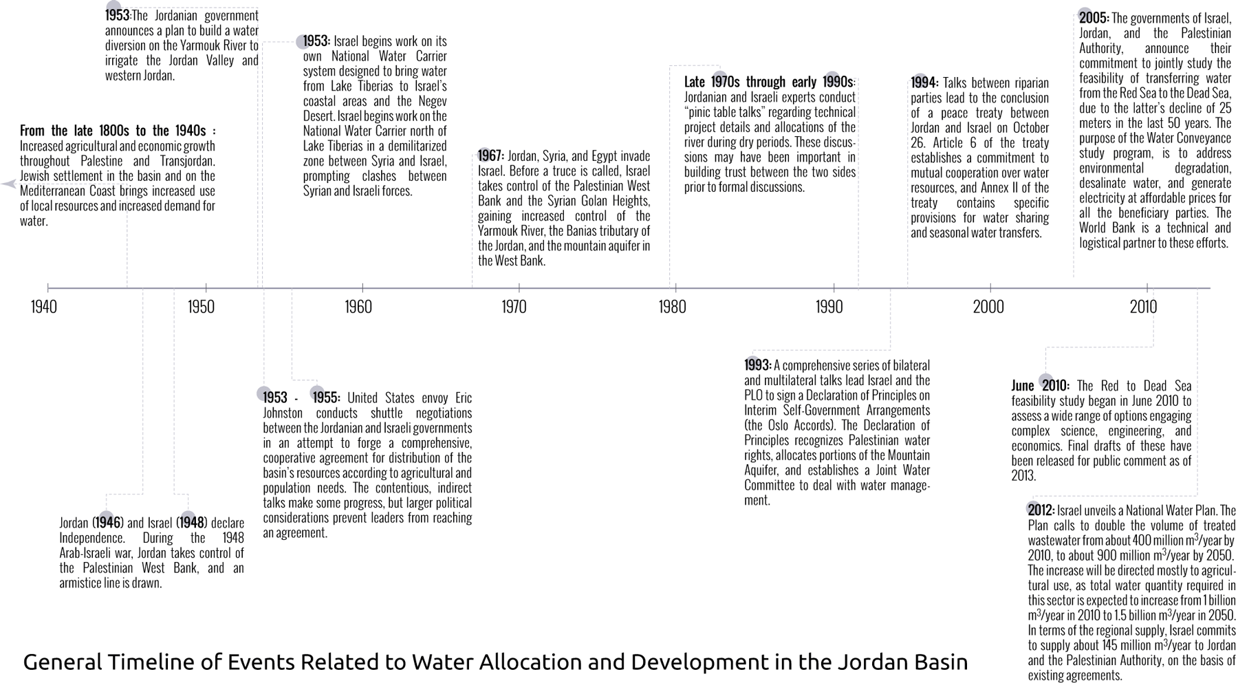
| 14:13, 12 November 2013 | GeneralTimeLineWaterSharingJordanBasin.png (file) |  |
238 KB | Amanda | better resolution | 2 |
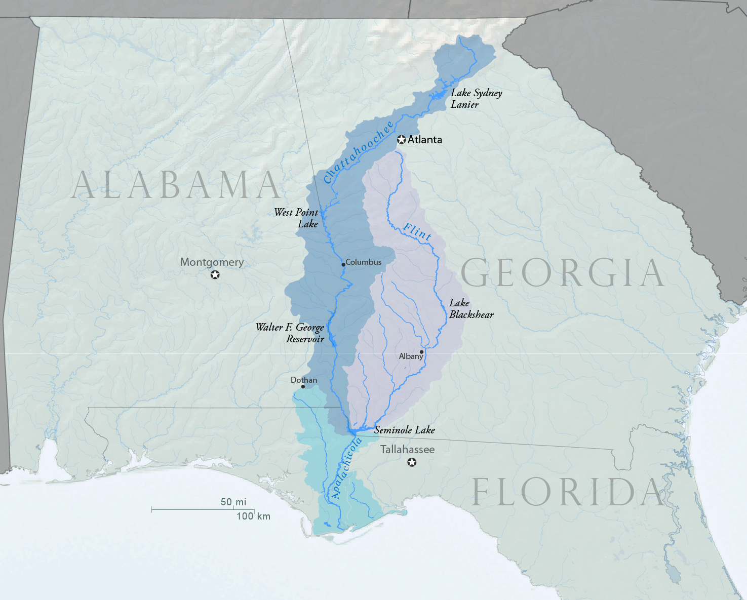
| 11:39, 10 October 2013 | ACF-overview.png (file) |  |
431 KB | Amanda | Map overview showing ACF (Apalachicola-Chattahoochee-Flint) Basin and major reservoirs within the basin. Created by Water Diplomacy using USGS and U.S. Census Bureau Data sources in October 2013. | 1 |
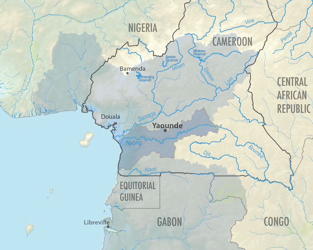
| 11:10, 24 September 2013 | Nyong-GulfofGuinea-Cameroon.png (file) |  |
619 KB | Amanda | The Nyong River Basin in Cameroon is one of the basins of Cameroon that drains to the Gulf of Guinea. This map was produced by Water Diplomacy for the AquaPedia Case Study Database. Data Sources: GADM v2.0 (Administrative Boundaries) and FAO AQUASTAT... | 1 |
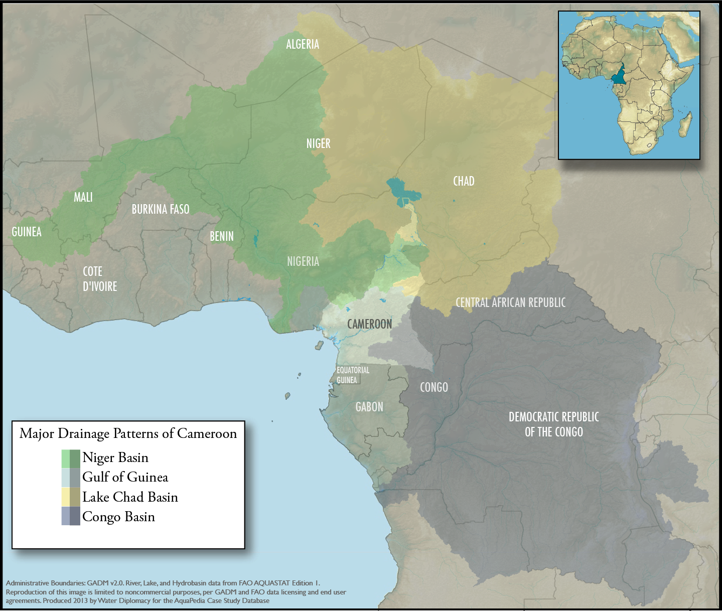
| 15:48, 23 September 2013 | Cameroon-regional-overview.png (file) |  |
1.43 MB | Amanda | An overview map showing Cameroon within the context of the 4 major drainage patterns: Niger Basin, Lake Chad, Congo Basin, and Gulf of Guinea. Produced by Water Diplomacy for Cameroon-related articles Data Sources: GADM v2.0 (Administrative Boundarie... | 1 |
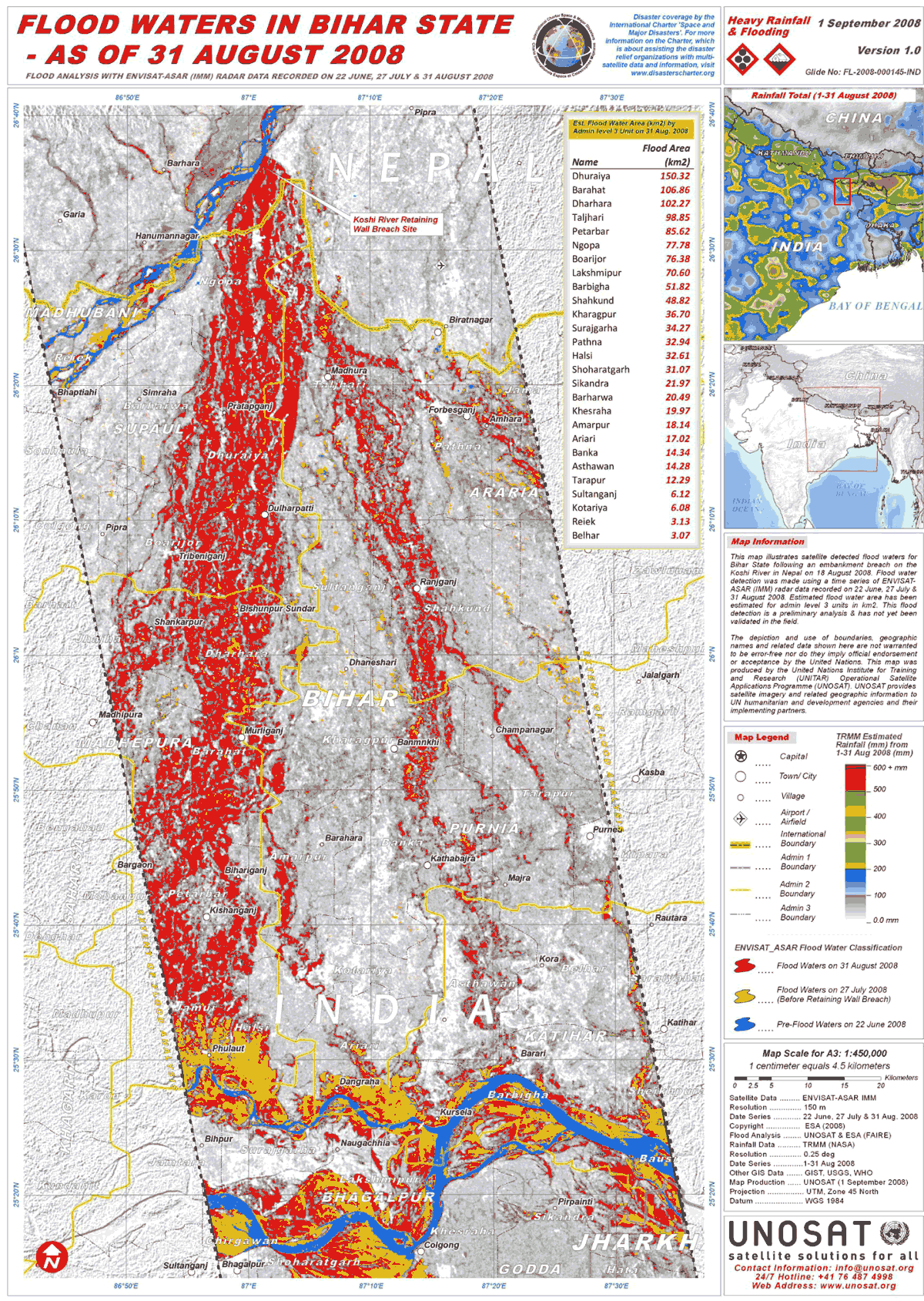
| 17:03, 25 June 2013 | UNOSAT IND Bihar Floods ASAR 31Aug08 Lowres.png (file) |  |
595 KB | Amanda | high-res .pdf available online: http://www.unitar.org/unosat/node/44/1259 Product ID: 1259 - English Published: 1 Sep, 2008 GLIDE: FL-2008-000145-IND “This map illustrates satellite detected flood waters for Bihar State following an embankment brea... | 1 |
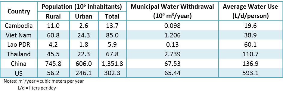
| 13:03, 20 May 2013 | Table 5 Water Consumption Comparison.jpg (file) |  |
51 KB | TAlarcon | Created by Tania Alarcon Data Source: Food and Agriculture Organization of the United Nations. (2013). AQUASTAT database. Retrieved from: www.fao.org/nr/water/aquastat/data/query/results.html | 1 |
| 12:52, 20 May 2013 | PPWSA Governance.jpg (file) |  |
49 KB | TAlarcon | Created by Tania Alarcon Data Source: Phnom Penh Water Supply Authority. (2013). History. Organization Structure. Production System. Distribution System. Water Quality. Non Revenue Water. Retrieved from: www.ppwsa.com.kh/en/index.php?page=history | 1 |
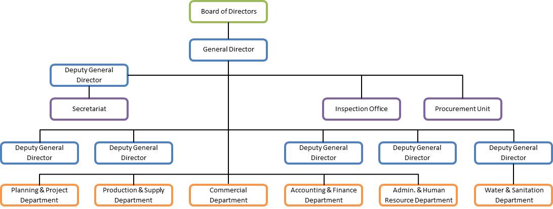
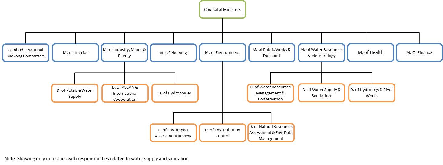
| 12:46, 20 May 2013 | Cambodia Governance.jpg (file) |  |
72 KB | TAlarcon | Created by Tania Alarcon Data Source: Phnom Penh Water Supply Authority. (2013). History. Organization Structure. Production System. Distribution System. Water Quality. Non Revenue Water. Retrieved from: www.ppwsa.com.kh/en/index.php?page=history Wate | 1 |
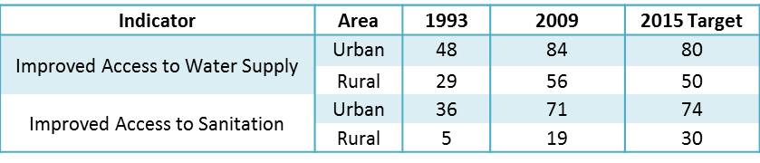
| 12:41, 20 May 2013 | Table 4 Cambodia Millenium Development Goals and Progress.jpg (file) | 23 KB | TAlarcon | Created by Tania Alarcon Data Source: Asian Development Bank. (2012). Cambodia: Water supply and sanitation sector assessment, strategy, and road map. Asian Development Bank, Mandaluyong City, Philippines. United Nations. (2013). Database - Millennium | 1 | |
| 12:32, 20 May 2013 | Table 3 PPWSA Water Quality (2012).jpg (file) | 50 KB | TAlarcon | Created by Tania Alarcon Data Source: Phnom Penh Water Supply Authority. (2013). History. Organization Structure. Production System. Distribution System. Water Quality. Non Revenue Water. Retrieved from: www.ppwsa.com.kh/en/index.php?page=history | 1 | |
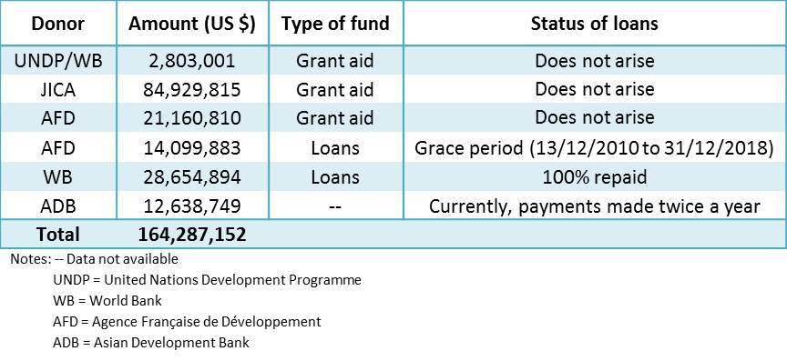
| 12:28, 20 May 2013 | Table 2 PPWSA Donors (1993 - 2009).jpg (file) | .jpg) |
59 KB | TAlarcon | Created by Tania Alarcon Data Source: Das, B., Chan, E. S., Visoth, C., Pangare, G., and Simpson, R., eds. (2010). Sharing the Reforms Process, Mekong Water Dialogue Publication No. 4, Gland, Switzerland: IUCN | 1 |
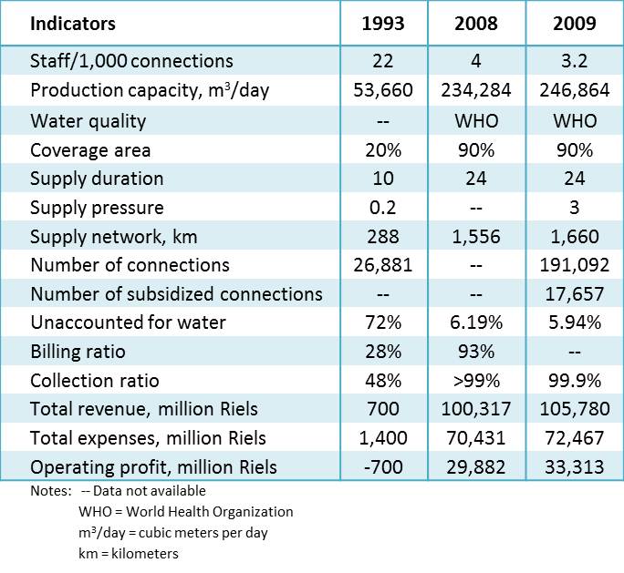
| 12:23, 20 May 2013 | Table 1 PPWSA Performance Indicators.jpg (file) |  |
76 KB | TAlarcon | 2 | |
| 14:51, 17 May 2013 | Cambodia map.jpg (file) |  |
51 KB | TAlarcon | Graphic Produced by Tania Alarcon Adapted from Wikipedia | 1 |
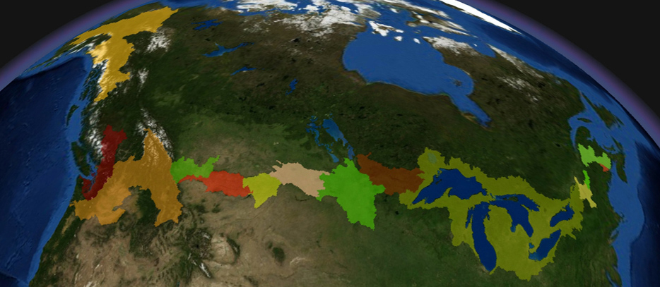
| 13:25, 17 May 2013 | CAN-US-Boundary-Waters.jpg (file) |  |
185 KB | Cvanrees | An image taken from the IJC website mapping transboundary waters and watersheds on the U.S. Canada border. | 1 |
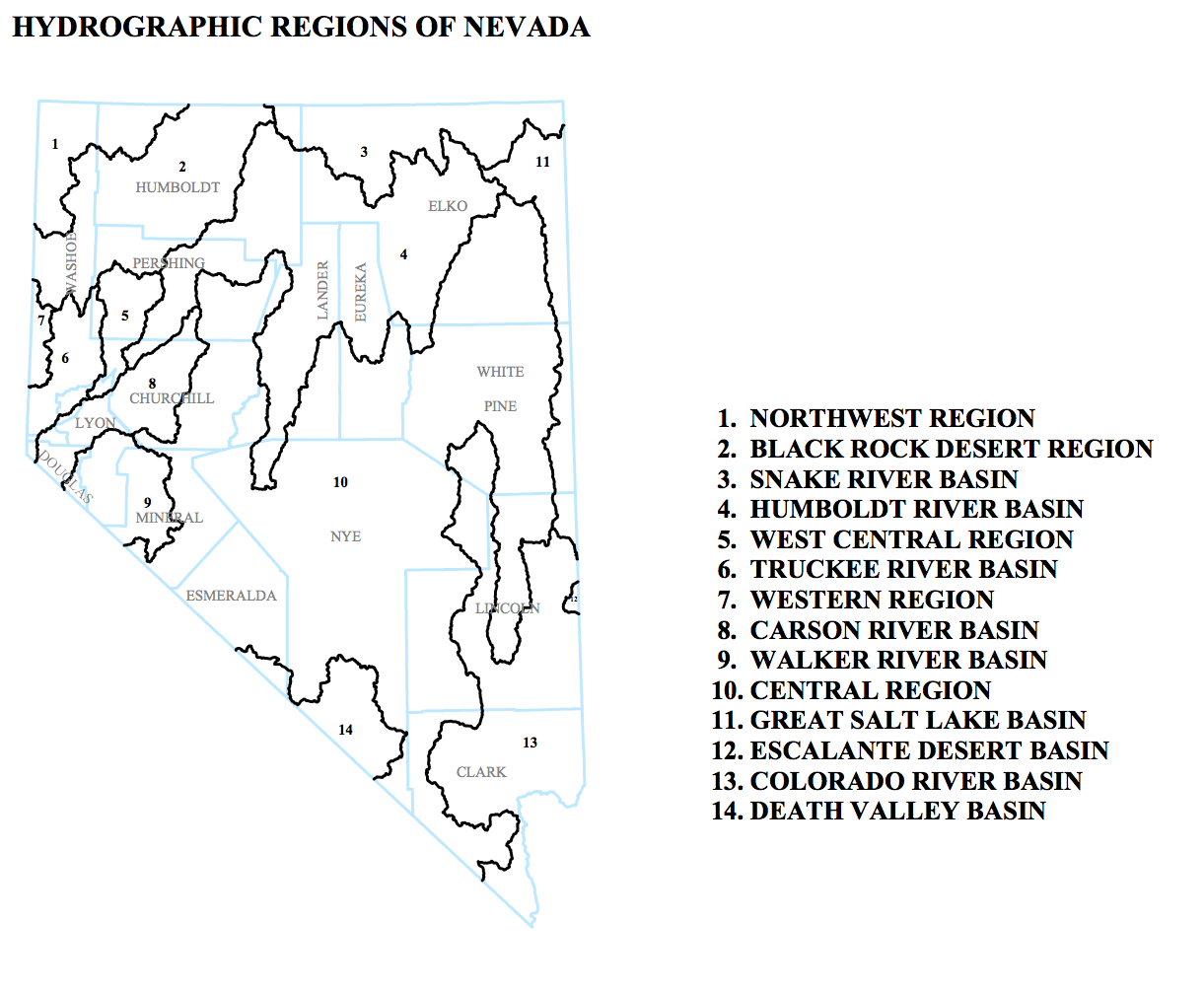
| 14:38, 16 May 2013 | Hydrographic-Regions-of-Nevada.png (file) |  |
203 KB | Amanda | This is an inset from a map entitled "DESIGNATED GROUNDWATER BASINS OF NEVADA" produced by: Department of Conservation and Natural Resources Office of the StateEngineer Division of Water Resources Carson City, Nevada 89701 In addition to the regions sh | 1 |
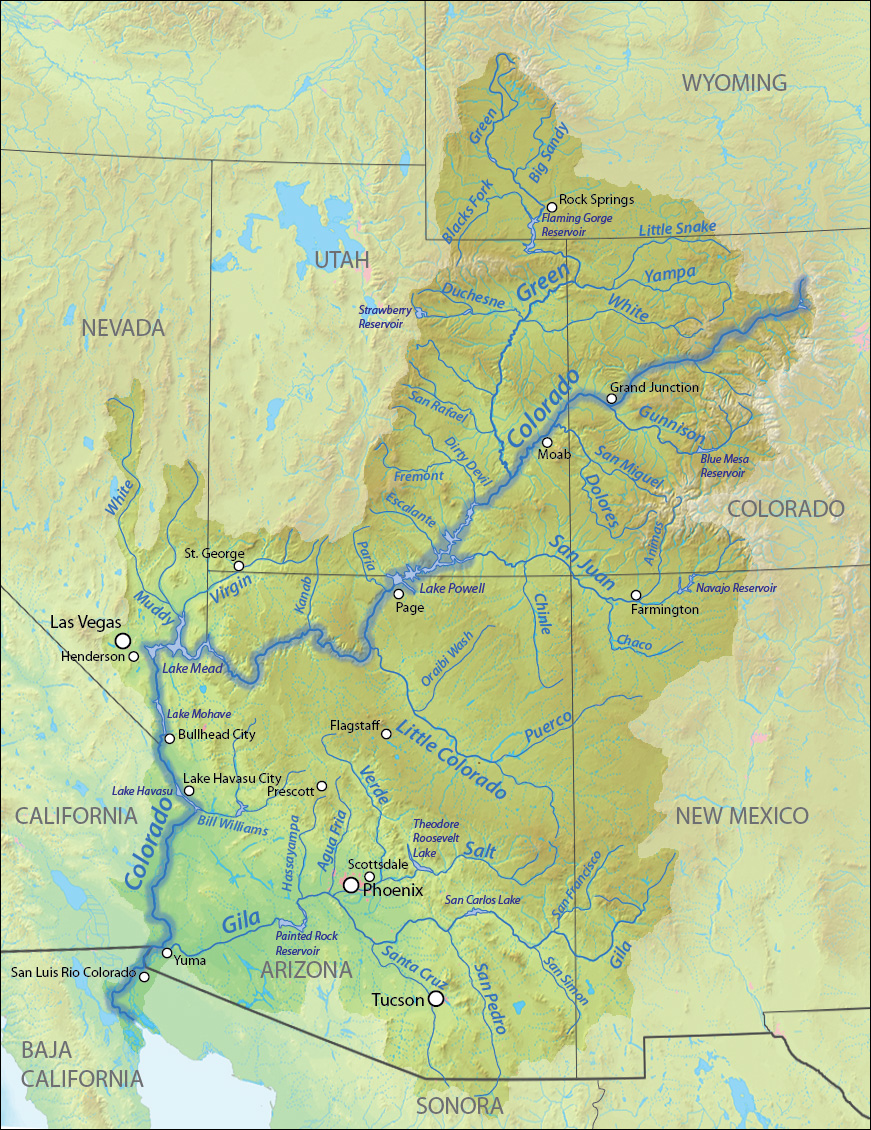
| 14:09, 16 May 2013 | Coloradorivermapnew1.jpg (file) |  |
701 KB | Amanda | Author: Wikimedia Commons user Shannon [GFDL (http://www.gnu.org/copyleft/fdl.html) or CC-BY-SA-3.0-2.5-2.0-1.0 (http://creativecommons.org/licenses/by-sa/3.0)], via Wikimedia Commons Background and river course data from http://www2.demis.nl/mapserver/m | 1 |
| 10:20, 16 May 2013 | Visitor Growth in Los Vegas from 1970 to 2012.png (file) |  |
59 KB | Amanda | Produced 2013 by Margaret Garcia for Water Competition & Cooperation in the Las Vegas Valley Tourism continued to grow and Las Vegas saw a huge boom in tourism with annual visitors steadily increasing from 1970 until the mid-1990s. source: Las Vega | 1 |
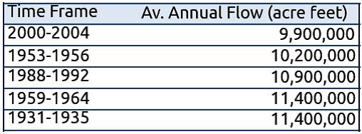
| 10:16, 16 May 2013 | AverageAnnualColoradoUSFlows.jpg (file) |  |
27 KB | Amanda | Produced 2013 by Margaret Garcia for Water Competition & Cooperation in the Las Vegas Valley | 1 |
| 12:03, 15 May 2013 | Logo size watersplash.png (file) |  |
10 KB | ACR | 2 | |
| 11:48, 15 May 2013 | Arrows-ffffff.png (file) |  |
4 KB | ACR | 2 | |
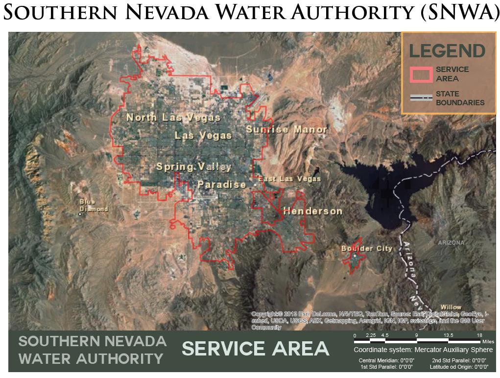
| 15:25, 14 May 2013 | SNWAMap.jpg (file) |  |
151 KB | Amanda | 2 | |
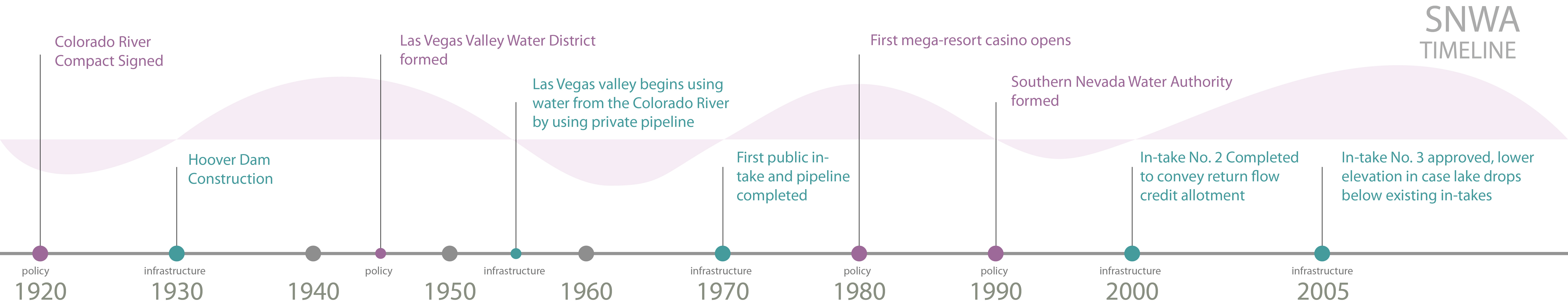
| 15:02, 14 May 2013 | SNWA Timeline 1920 - 2005.jpg (file) | 857 KB | Amanda | Produced by Margaret Garcia for Water Competition & Cooperation in the Las Vegas Valley | 1 | |
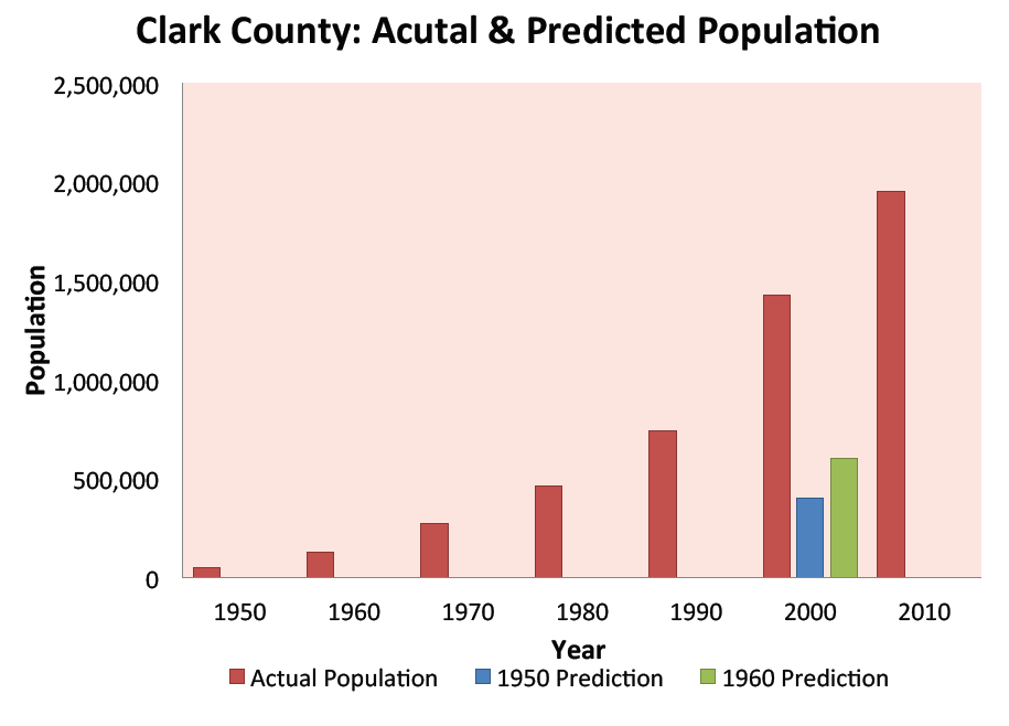
| 14:48, 14 May 2013 | Clark County Population Growth 1950 - 2010.png (file) |  |
31 KB | Amanda | Graphic Produced by Margaret Garcia for Water Competition & Cooperation in the Las Vegas Valley | 1 |
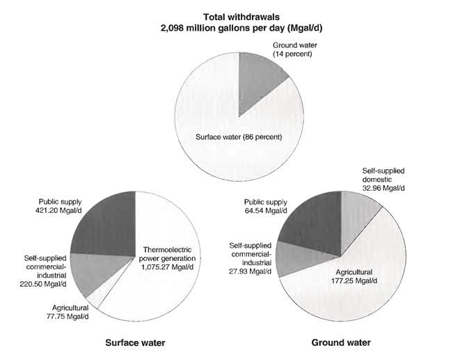
| 16:30, 28 February 2013 | ACF-total-withdrawal-pie-chart.png (file) |  |
55 KB | Amanda | This is figure 29. Ground- and surface-water withdrawals by principal water use-categories in the Apalachicola-Chattahoochee-Flint River basin, 1990 (data from Marella andothers, 1993) which appeared in Influences of environmental settings on aquatic ecos | 1 |
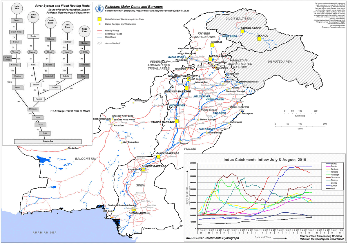
| 15:22, 31 January 2013 | Indus River Pakistan Dams WFP 2010 example.png (file) |  |
202 KB | Amanda | Very low res (screen preview) version of map available from: [http://www.wfp.org/maps/pakistan-major-dams-and-barrages-11-august-2010-high-resolution] or from [http://epmaps.wfp.org/maps/04165_20100812_PAK_A4_ODEP_Pakistan__Major_Dams_and_Barrages,_11 | 1 |
| 16:07, 25 January 2013 | AP-screenshot-WMC.png (file) |  |
92 KB | Amanda | Screenshot showing how to incorporate a file from Wikimedia Commons into an AquaPedia Case | 1 |
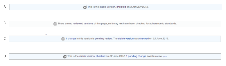
| 13:41, 25 January 2013 | Aquapedia-screenshot-pending-changes-tab.png (file) | 21 KB | Amanda | screenshot of AquaPedia page tabs showing the "Pending Changes" tab | 1 | |
| 16:33, 7 January 2013 | Aquapedia-screenshot-review-status-options.png (file) |  |
27 KB | Amanda | screenshots showing various Case or Article Review Statuses | 1 |
| 16:30, 7 January 2013 | Aquapedia-screenshot-explain-tabs-links.png (file) |  |
492 KB | Amanda | An explanation of navigation tabs for cases and overall navigation via annotated screenshot. CC by SA 3.0 | 2 |
| 16:07, 7 January 2013 | AquaPedia-Screenshot-case2.png (file) |  |
78 KB | Amanda | CC by SA 3.0 Screenshot showing case study sections. | 1 |
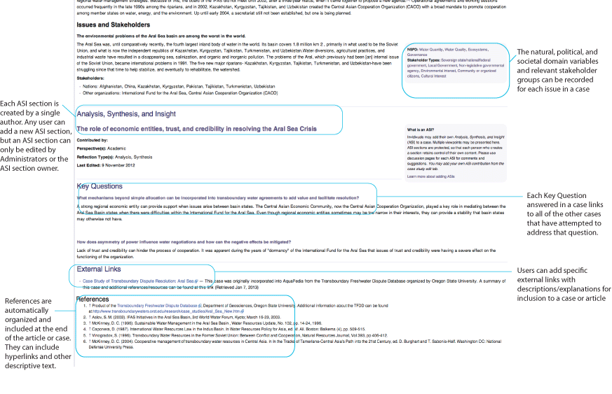
| 15:31, 7 January 2013 | AquaPedia-Screenshot-case1.png (file) |  |
50 KB | Amanda | Screenshot with notation showing some of the parts of a case study. | 1 |
| 11:31, 7 January 2013 | Help-asterisk-explained.png (file) |  |
483 B | Amanda | Icon used in help pages in a div explaining more about a topic, following an asterisk. | 1 |
| 11:27, 29 August 2012 | Lesotho Highlands.jpg (file) |  |
17 KB | Mpritchard | Wide use of electronic and hardcopy versions of data, GIS coverages, and findings produced by the Transboundary Freshwater Dispute Database (TFDD) project is encouraged. The data, coverages, and findings are not copyrighted, although due credit is apprec | 1 |
First page |
Previous page |
Next page |
Last page |


.jpg)