Conflict Management Strategies Among Riparians Within the Indus River Basin
| Geolocation: | 31° 32' 44.5492", 74° 20' 22.3537" |
|---|---|
| Total Population | 178,483,470178,483,470,000,000 millionmillion |
| Total Area | 1,138,8001,138,800 km² 439,690.68 mi² km2 |
| Climate Descriptors | Moist tropical (Köppen A-type), Semi-arid/steppe (Köppen B-type), Humid mid-latitude (Köppen C-type), Continental (Köppen D-type), Moist, Monsoon |
| Predominent Land Use Descriptors | agricultural- cropland and pasture, industrial use, forest land, urban- high density, religious/cultural sites |
| Important Uses of Water | Agriculture or Irrigation, Domestic/Urban Supply, Hydropower Generation |
Contents
Summary
Even before the partition of India and Pakistan, the Indus posed problems between the states of British India. The problem became international only after partition, though, and the attendant increased hostility and lack of supra-legal authority only exacerbated the issue. Pakistani territory, which had relied on Indus water for centuries, now found the water sources originating in another country, one with whom geopolitical relations were increasing in hostility. Numerous treaties and agreements were proposed from 1947 through 1960, yet none were able to transform the conflict, and arguments continued up until the Indus Water Agreement of 1960. The Indus Water Treaty was signed in Karachi on September 19, 1960 and government ratifications were exchanged in Delhi in January 1961. The Indus Water Treaty was developed by the World Bank and addressed both the technical and financial concerns of each side, and included a timeline for transition. The treaty also established the Permanent Indus Commission, made up of one Commissioner of Indus Waters from each country. The question over the flow of the Indus is a classic case of the conflicting claims of up- and down-stream riparians. Since 1960, no projects have been submitted under the provisions for "future cooperation," nor have any issues of water quality been submitted at all. Other disputes have arisen, and been handled in a variety of ways. One controversy surrounding the design and construction of the Salal Dam was resolved through bilateral negotiations between the two governments. Other disputes, over new hydroelectric projects and the Wuller Barrage on the Jhelum tributary and the Baglihar dam on the Chenab River in Kashmir, have yet to be resolved. Pakistan has indicated that it might seek World Bank arbitration if the matter is not sorted out through bilateral talks.
Natural, Historic, Economic, Regional, and Political Framework
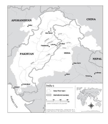
 Figure 1. Map of the Indus River Basin [1]
The Problem
Even before the partition of India and Pakistan, the Indus posed problems between the states of British India. The problem became international only after partition, though, and the attendant increased hostility and lack of supra-legal authority only exacerbated the issue. Pakistani territory, which had relied on Indus water for centuries, now found the water sources originating in another country, one with whom geopolitical relations were increasing in hostility. The question over the flow of the Indus is a classic case of the conflicting claims of up- and down-stream riparians. The conflict can be exemplified in the terms for the resumption of water delivery to Pakistan from the Indian headworks, worked out at an Inter-Dominican conference held in Delhi on 3-4 May 1948. India agreed to the resumption of flow, but maintained that Pakistan could not claim any share of those waters as a matter of right [2]. This position was reinforced by the Indian claim that, since Pakistan had agreed to pay for water under the Standstill Agreement of 1947, Pakistan had recognized India’s water rights. Pakistan countered that they had the rights of prior appropriation, and that payments to India were only to cover operation and maintenance costs [3]
Analysis, Synthesis, and Insight
Individuals may add their own Analysis, Synthesis, and Insight (ASI) to a case. ASI sub-articles are protected, so that each contributor retains authorship and control of their own content. Edit the case to add your own ASI.
Learn moreASI:Conflict Management in the Indus Basin: Insights from the Transboundary Freshwater Dispute Database
The points included here are summarized or excerpted from the Oregon State University Transboundary Freshwater Dispute Database (TFDD). Matthew Pritchard provided this and other summarized analysis or insights from the TFFD on behalf and with permission of the original authors. Available on-line at: http://www.transboundarywaters.orst.edu/
This ASI discusses some lessons learned from the negotiations and creative outcomes in the agreement.(read the full article... )
Contributed by: Aaron T. Wolf, Joshua T. Newton, Matthew Pritchard (last edit: 12 February 2013)
- ^ Product of the Transboundary Freshwater Dispute Database, Department of Geosciences, Oregon State University. Additional information about the TFDD can be found at: http://www.transboundarywaters.orst.edu
- ^ Caponera, D. (1987). International Water Resources Law in the Indus Basin. In Water Resources Policy for Asia, ed. M. Ali. Boston: Balkema (4), pp. 509-515.
- ^ Biswas, A. (1992). Indus Water Treaty: The Negotiating Process. Water International, 17, (44), pp. 201- 209


