File list
This special page shows all uploaded files.
| Name | Thumbnail | Size | User | Description | Versions | |
|---|---|---|---|---|---|---|
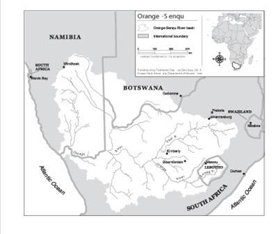
| 11:27, 29 August 2012 | Lesotho Highlands.jpg (file) |  |
17 KB | Mpritchard | Wide use of electronic and hardcopy versions of data, GIS coverages, and findings produced by the Transboundary Freshwater Dispute Database (TFDD) project is encouraged. The data, coverages, and findings are not copyrighted, although due credit is apprec | 1 |
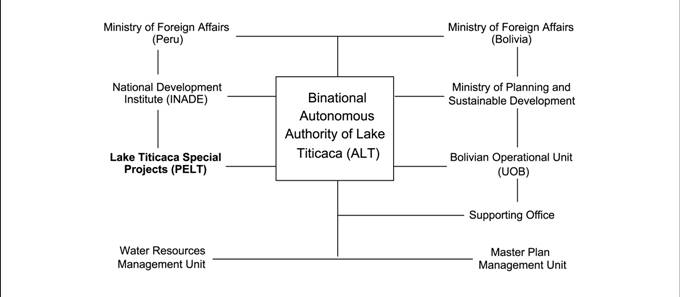
| 17:01, 27 August 2012 | ALTorgchart.jpg (file) |  |
18 KB | Mpritchard | Wide use of electronic and hardcopy versions of data, GIS coverages, and findings produced by the Transboundary Freshwater Dispute Database (TFDD) project is encouraged. The data, coverages, and findings are not copyrighted, although due credit is apprec | 1 |
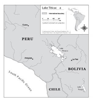
| 16:41, 27 August 2012 | Laketiticacatfddimage.jpg (file) |  |
11 KB | Mpritchard | Wide use of electronic and hardcopy versions of data, GIS coverages, and findings produced by the Transboundary Freshwater Dispute Database (TFDD) project is encouraged. The data, coverages, and findings are not copyrighted, although due credit is apprec | 1 |
| 11:05, 23 August 2012 | Umatillanewmap.jpg (file) |  |
75 KB | Mpritchard | Created and provided by Dr. Todd Jarvis, Director of the Institute for Water and Watersheds, Oregon State University. The image is not copyrighted, though due credit is appreciated. Please attach the above credit when used. | 1 |
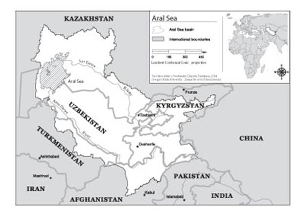
| 15:26, 21 August 2012 | Aral Sea.jpg (file) |  |
28 KB | Mpritchard | Wide use of electronic and hardcopy versions of data, GIS coverages, and findings produced by the Transboundary Freshwater Dispute Database (TFDD) project is encouraged. The data, coverages, and findings are not copyrighted, although due credit is apprec | 1 |
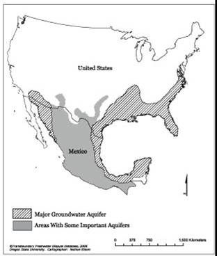
| 10:43, 21 August 2012 | US Mexico Aquifers.jpg (file) |  |
15 KB | Mpritchard | Wide use of electronic and hardcopy versions of data, GIS coverages, and findings produced by the Transboundary Freshwater Dispute Database (TFDD) project is encouraged. The data, coverages, and findings are not copyrighted, although due credit is apprec | 1 |
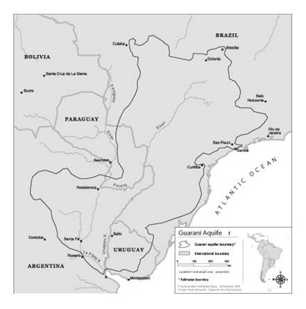
| 13:38, 20 August 2012 | Guarani Aquifer.jpg (file) |  |
20 KB | Mpritchard | Wide use of electronic and hardcopy versions of data, GIS coverages, and findings produced by the Transboundary Freshwater Dispute Database (TFDD) project is encouraged. The data, coverages, and findings are not copyrighted, although due credit is apprec | 1 |
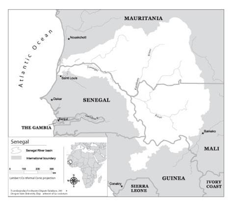
| 12:26, 16 August 2012 | Senegalriver.jpg (file) |  |
19 KB | Mpritchard | Wide use of electronic and hardcopy versions of data, GIS coverages, and findings produced by the Transboundary Freshwater Dispute Database (TFDD) project is encouraged. The data, coverages, and findings are not copyrighted, although due credit is apprec | 1 |
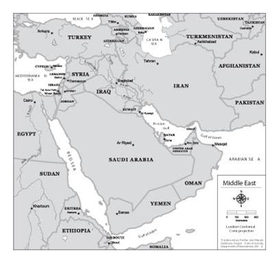
| 14:27, 15 August 2012 | Middleeastwater.jpg (file) |  |
20 KB | Mpritchard | Wide use of electronic and hardcopy versions of data, GIS coverages, and findings produced by the Transboundary Freshwater Dispute Database (TFDD) project is encouraged. The data, coverages, and findings are not copyrighted, although due credit is apprec | 1 |
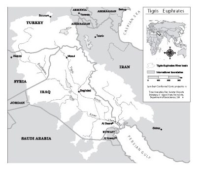
| 11:42, 14 August 2012 | Tigriseuphrates.jpg (file) |  |
30 KB | Mpritchard | Wide use of electronic and hardcopy versions of data, GIS coverages, and findings produced by the Transboundary Freshwater Dispute Database (TFDD) project is encouraged. The data, coverages, and findings are not copyrighted, although due credit is apprec | 1 |
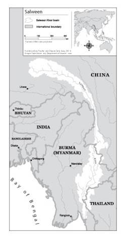
| 11:47, 6 August 2012 | Salweenriverbasin.jpg (file) |  |
14 KB | Mpritchard | Wide use of electronic and hardcopy versions of data, GIS coverages, and findings produced by the Transboundary Freshwater Dispute Database (TFDD) project is encouraged. The data, coverages, and findings are not copyrighted, although due credit is apprec | 1 |
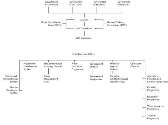
| 13:33, 2 August 2012 | Mekongcommitteeorgchart.jpg (file) |  |
18 KB | Mpritchard | Wide use of electronic and hardcopy versions of data, GIS coverages, and findings produced by the Transboundary Freshwater Dispute Database (TFDD) project is encouraged. The data, coverages, and findings are not copyrighted, although due credit is apprec | 1 |
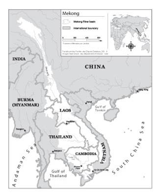
| 13:11, 2 August 2012 | Mekongriverbasin.jpg (file) |  |
17 KB | Mpritchard | Map of the Mekong River Basin. Wide use of electronic and hardcopy versions of data, GIS coverages, and findings produced by the Transboundary Freshwater Dispute Database (TFDD) project is encouraged. The data, coverages, and findings are not copyrighted | 1 |
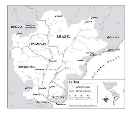
| 14:16, 1 August 2012 | Laplata.jpg (file) |  |
18 KB | Mpritchard | Wide use of electronic and hardcopy versions of data, GIS coverages, and findings produced by the Transboundary Freshwater Dispute Database (TFDD) project is encouraged. The data, coverages, and findings are not copyrighted, although due credit is apprec | 1 |
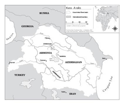
| 12:57, 1 August 2012 | Kuraaraks.jpg (file) |  |
16 KB | Mpritchard | Wide use of electronic and hardcopy versions of data, GIS coverages, and findings produced by the Transboundary Freshwater Dispute Database (TFDD) project is encouraged. The data, coverages, and findings are not copyrighted, although due credit is apprec | 1 |
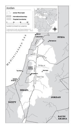
| 14:51, 31 July 2012 | Jordanriverbasin.jpg (file) |  |
15 KB | Mpritchard | Map of the Jordan River and tributaries (directly and indirectly, including Litani) Wide use of electronic and hardcopy versions of data, GIS coverages, and findings produced by the Transboundary Freshwater Dispute Database (TFDD) project is encouraged. | 1 |
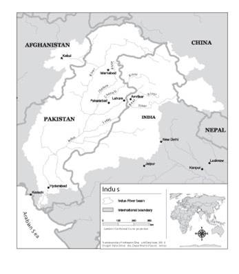
| 11:56, 31 July 2012 | Indusriverbasin.jpg (file) |  |
15 KB | Mpritchard | Map of the Indus River Basin. Wide use of electronic and hardcopy versions of data, GIS coverages, and findings produced by the Transboundary Freshwater Dispute Database (TFDD) project is encouraged. The data, coverages, and findings are not copyrighted, | 1 |
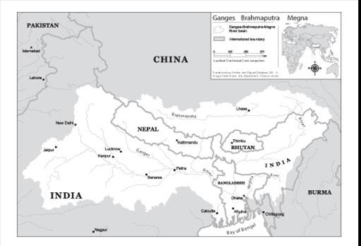
| 12:13, 30 July 2012 | GangesBasin.jpg (file) |  |
21 KB | Mpritchard | Map of the Ganges- Brahmaputra-Megna basin (TFDD, 2012).“Product of the Transboundary Freshwater Dispute Database, Department of Geosciences, Oregon State University. Additional information about the TFDD can be found at: <http://www.transboundarywater | 1 |
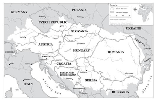
| 14:20, 27 July 2012 | DanudeRiverBasin.jpg (file) |  |
28 KB | Mpritchard | Map of the Danube River Basin “Product of the Transboundary Freshwater Dispute Database, Department of Geosciences, Oregon State University. Additional information about the TFDD can be found at: <http://www.transboundarywaters.orst.edu>.” | 1 |
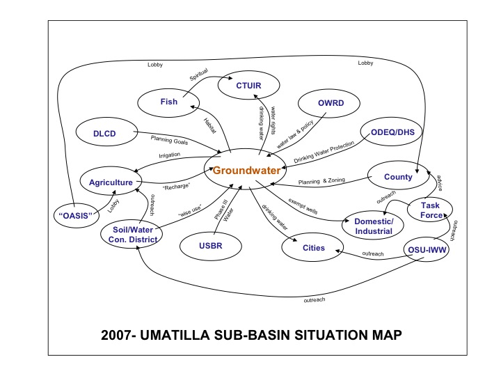
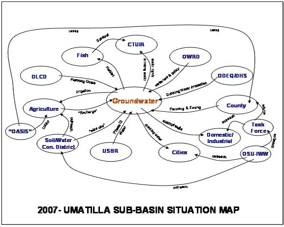
| 12:05, 27 July 2012 | 2007Umatillasubbasinsituationmap.jpg (file) |  |
46 KB | Mpritchard | Preliminary depiction of stakeholders and linkages for the groundwater situation in the Umatilla Basin, Northwestern US. “OASIS” was a proposed project to divert water from the Columbia River. DLCD denotes the Oregon Department of Land and Conservatio | 1 |
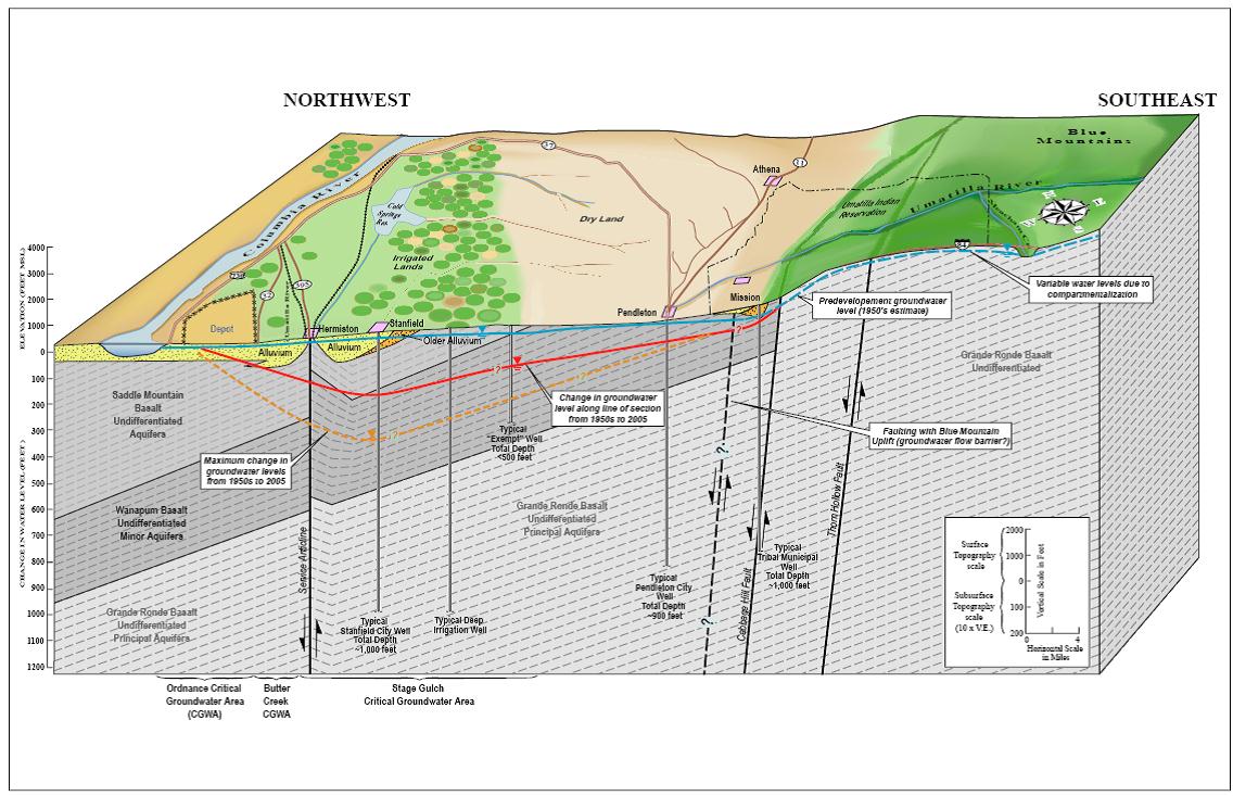
| 11:56, 27 July 2012 | BlockdiagramofUmatillaBasinhydrogeology.jpg (file) |  |
171 KB | Mpritchard | “Product of the Transboundary Freshwater Dispute Database, Department of Geosciences, Oregon State University. Additional information about the TFDD can be found at: <http://www.transboundarywaters.orst.edu>.” | 1 |


