File list
This special page shows all uploaded files.
| Name | Thumbnail | Size | User | Description | Versions | |
|---|---|---|---|---|---|---|
| 13:54, 1 August 2014 | Site-main-slide04-01.png (file) | 120 KB | Amanda | A slide for the main paige to promote the AquaPedia RFP | 1 | |
| 13:54, 1 August 2014 | Site-main-slide03-01.png (file) | 115 KB | Amanda | A slide for the main paige to promote the AquaPedia RFP | 1 | |
| 14:34, 31 July 2014 | Buesser, Christine - Gaza Water Management Presentation MIT May 2014 external use.pdf (file) | 1.61 MB | Amanda | Slides from a presentation by Christine Buesser, at MIT for the 2014 Spring Semester Water Diplomacy course, May 15, 2014 Images within the presentation are subject to the copyright of their original source. This file is included here because it i... | 1 | |
| 09:58, 29 July 2014 | Site-main-slide01.png (file) | 25 KB | Amanda | This image is used on the main page javascript slide show | 1 | |
| 09:57, 29 July 2014 | Site-main-slide02.png (file) | 103 KB | Amanda | This is a descriptive slide used on the main page. | 1 | |
| 13:01, 26 June 2014 | CMWU-2010-nitrate.png (file) | 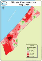 |
313 KB | Amanda | From CMWU Annual Report 2010, Coastal Municipalities Water Utility, Palestine, 2011. Online at: http://www.cmwu.ps/en/yreports.php?view=17 | 1 |
| 13:00, 26 June 2014 | CMWU-2010-chloride.png (file) | 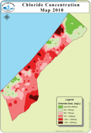 |
280 KB | Amanda | From CMWU Annual Report 2010, Coastal Municipalties Water Utility, Palestine, 2011. Online at: http://www.cmwu.ps/en/yreports.php?view=17 | 1 |
| 10:06, 26 June 2014 | Coastal-Aquifer-Schematic.png (file) | 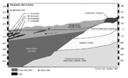 |
393 KB | Amanda | Geologic Schematic of the Coastal Aquifer from: Greitzer, D. J. Dan. 1967, The effect of soil landscape and quaternary geology on the distribution of saline and freshwater aquifers in the Coastal Plain of Israel, Water Planning for Israel, Tel Aviv, L... | 1 |
| 09:20, 26 June 2014 | Coastal-Aquifer-Extent.png (file) | 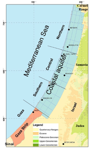 |
210 KB | Amanda | low-res Image showing the extent of the Coastal Aquifer. This image is figure 17 in : Weinberger, G. et al. 2012. The Natural Water Resources between the Meditteranean Sea and the Jordan River. Israel Hydrologic Service. Jerusalem. online: http://www.... | 1 |
| 11:56, 16 May 2014 | GLEAM Great Lakes Environmental Stress Map.png (file) | 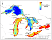 |
169 KB | Amanda | Great Lakes Environmental Stress Map, 2012. This is a product of the Great Lakes Environmental Assessment and Mapping (GLEAM) Project. http://www.greatlakesmapping.org/ Additional maps, descriptive documents, and other resources may be found here: ... | 1 |
| 11:44, 16 May 2014 | Great Lakes Drainage Basin Env Canada.jpg (file) | 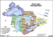 |
852 KB | Amanda | This map depicts the sub-basins within the Great Lakes drainage basin. This is a reproduction of a map produced by Environment Canada. It is a copy of an official work that is published by the Government of Canada and that the reproduction has not bee... | 1 |
| 11:04, 16 May 2014 | Great Lakes Basin Map.gif (file) |  |
17 KB | Amanda | GLIN map of Great Lakes region with adjacent U.S. States and Candaian provinces, highlighting drainage basin http://www.great-lakes.net/lakes/ | 1 |
| 10:31, 16 May 2014 | GreatLakes-AOC-USEPA.png (file) | 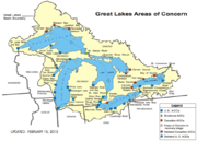 |
151 KB | Amanda | adapted from - http://www.epa.gov/greatlakes/aoc/images/aoc-glbasin-map-20130215.pdf "The U.S.-Canada Great Lakes Water Quality Agreement (Annex 2 of the 1987 Protocol) defines AOCs as "geographic areas that fail to meet the general or specific object... | 1 |
| 08:29, 18 March 2014 | GBM monthly average precip.gif (file) |  |
335 KB | Amanda | animated .GIF illustrating average monthly precipitation values in the Ganges-Brahmaputra-Meghna Basin (India, Nepal, China (Tibet), Bhutan, Bangladesh, Myanmar) Precipiation values from 30 arc-second World Clim global data set. Interpolated average p... | 1 |
| 09:53, 9 January 2014 | Schematic of Govt Water Data Exchange Lebanon UNESCWA.png (file) | 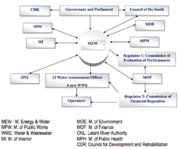 |
39 KB | Amanda | Data Exchange between government water stakeholders in Lebanon (UNESCWA) This figure is from UNESCWA. WATER IN LEBANON STRATEGIC MANAGEMENT DATA NATIONAL ASSESSMENT MATRIX. 2012. Presentation PDF Online at https://unstats.un.org/unsd/envaccounting/wo... | 1 |
| 14:13, 12 November 2013 | GeneralTimeLineWaterSharingJordanBasin.png (file) |  |
238 KB | Amanda | better resolution | 2 |
| 11:39, 10 October 2013 | ACF-overview.png (file) | 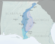 |
431 KB | Amanda | Map overview showing ACF (Apalachicola-Chattahoochee-Flint) Basin and major reservoirs within the basin. Created by Water Diplomacy using USGS and U.S. Census Bureau Data sources in October 2013. | 1 |
| 11:10, 24 September 2013 | Nyong-GulfofGuinea-Cameroon.png (file) | 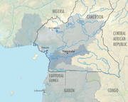 |
619 KB | Amanda | The Nyong River Basin in Cameroon is one of the basins of Cameroon that drains to the Gulf of Guinea. This map was produced by Water Diplomacy for the AquaPedia Case Study Database. Data Sources: GADM v2.0 (Administrative Boundaries) and FAO AQUASTAT... | 1 |
| 15:48, 23 September 2013 | Cameroon-regional-overview.png (file) | 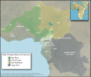 |
1.43 MB | Amanda | An overview map showing Cameroon within the context of the 4 major drainage patterns: Niger Basin, Lake Chad, Congo Basin, and Gulf of Guinea. Produced by Water Diplomacy for Cameroon-related articles Data Sources: GADM v2.0 (Administrative Boundarie... | 1 |
| 17:03, 25 June 2013 | UNOSAT IND Bihar Floods ASAR 31Aug08 Lowres.png (file) | 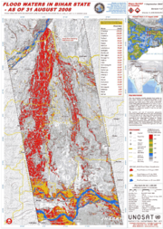 |
595 KB | Amanda | high-res .pdf available online: http://www.unitar.org/unosat/node/44/1259 Product ID: 1259 - English Published: 1 Sep, 2008 GLIDE: FL-2008-000145-IND “This map illustrates satellite detected flood waters for Bihar State following an embankment brea... | 1 |
| 14:38, 16 May 2013 | Hydrographic-Regions-of-Nevada.png (file) | 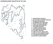 |
203 KB | Amanda | This is an inset from a map entitled "DESIGNATED GROUNDWATER BASINS OF NEVADA" produced by: Department of Conservation and Natural Resources Office of the StateEngineer Division of Water Resources Carson City, Nevada 89701 In addition to the regions sh | 1 |
| 14:09, 16 May 2013 | Coloradorivermapnew1.jpg (file) | 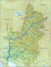 |
701 KB | Amanda | Author: Wikimedia Commons user Shannon [GFDL (http://www.gnu.org/copyleft/fdl.html) or CC-BY-SA-3.0-2.5-2.0-1.0 (http://creativecommons.org/licenses/by-sa/3.0)], via Wikimedia Commons Background and river course data from http://www2.demis.nl/mapserver/m | 1 |
| 10:20, 16 May 2013 | Visitor Growth in Los Vegas from 1970 to 2012.png (file) | 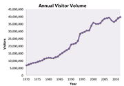 |
59 KB | Amanda | Produced 2013 by Margaret Garcia for Water Competition & Cooperation in the Las Vegas Valley Tourism continued to grow and Las Vegas saw a huge boom in tourism with annual visitors steadily increasing from 1970 until the mid-1990s. source: Las Vega | 1 |
| 10:16, 16 May 2013 | AverageAnnualColoradoUSFlows.jpg (file) |  |
27 KB | Amanda | Produced 2013 by Margaret Garcia for Water Competition & Cooperation in the Las Vegas Valley | 1 |
| 15:25, 14 May 2013 | SNWAMap.jpg (file) | 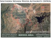 |
151 KB | Amanda | 2 | |
| 15:02, 14 May 2013 | SNWA Timeline 1920 - 2005.jpg (file) | 857 KB | Amanda | Produced by Margaret Garcia for Water Competition & Cooperation in the Las Vegas Valley | 1 | |
| 14:48, 14 May 2013 | Clark County Population Growth 1950 - 2010.png (file) | 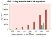 |
31 KB | Amanda | Graphic Produced by Margaret Garcia for Water Competition & Cooperation in the Las Vegas Valley | 1 |
| 16:30, 28 February 2013 | ACF-total-withdrawal-pie-chart.png (file) | 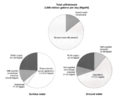 |
55 KB | Amanda | This is figure 29. Ground- and surface-water withdrawals by principal water use-categories in the Apalachicola-Chattahoochee-Flint River basin, 1990 (data from Marella andothers, 1993) which appeared in Influences of environmental settings on aquatic ecos | 1 |
| 15:22, 31 January 2013 | Indus River Pakistan Dams WFP 2010 example.png (file) | 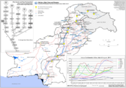 |
202 KB | Amanda | Very low res (screen preview) version of map available from: [http://www.wfp.org/maps/pakistan-major-dams-and-barrages-11-august-2010-high-resolution] or from [http://epmaps.wfp.org/maps/04165_20100812_PAK_A4_ODEP_Pakistan__Major_Dams_and_Barrages,_11 | 1 |
| 16:07, 25 January 2013 | AP-screenshot-WMC.png (file) | 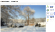 |
92 KB | Amanda | Screenshot showing how to incorporate a file from Wikimedia Commons into an AquaPedia Case | 1 |
| 13:41, 25 January 2013 | Aquapedia-screenshot-pending-changes-tab.png (file) | 21 KB | Amanda | screenshot of AquaPedia page tabs showing the "Pending Changes" tab | 1 | |
| 16:33, 7 January 2013 | Aquapedia-screenshot-review-status-options.png (file) |  |
27 KB | Amanda | screenshots showing various Case or Article Review Statuses | 1 |
| 16:30, 7 January 2013 | Aquapedia-screenshot-explain-tabs-links.png (file) | 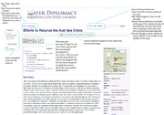 |
492 KB | Amanda | An explanation of navigation tabs for cases and overall navigation via annotated screenshot. CC by SA 3.0 | 2 |
| 16:07, 7 January 2013 | AquaPedia-Screenshot-case2.png (file) | 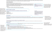 |
78 KB | Amanda | CC by SA 3.0 Screenshot showing case study sections. | 1 |
| 15:31, 7 January 2013 | AquaPedia-Screenshot-case1.png (file) | 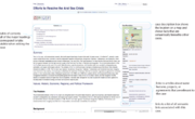 |
50 KB | Amanda | Screenshot with notation showing some of the parts of a case study. | 1 |
| 11:31, 7 January 2013 | Help-asterisk-explained.png (file) |  |
483 B | Amanda | Icon used in help pages in a div explaining more about a topic, following an asterisk. | 1 |
| 15:05, 16 July 2012 | Warning triangle.png (file) |  |
3 KB | Amanda | Created for AquaPedia. Released to Public Domain. CC-0. | 1 |
| 15:01, 16 July 2012 | External link icon.png (file) | 8 KB | Amanda | background removed | 2 | |
| 14:13, 16 July 2012 | Wikify icon.png (file) | 3 KB | Amanda | created for AquaPedia. available for use under CC-0 License. http://creativecommons.org/about/cc0 | 1 | |
| 13:56, 16 July 2012 | Question book edit.png (file) |  |
5 KB | Amanda | This file was edited from a file available from http://en.wikipedia.org/wiki/File:Question_book-new.svg (which was created by Wikipedia user Tkgd2007, and based on a similar image created by a different user). Image is available for use by anyone under a | 1 |
| 15:00, 2 July 2012 | Broom-icon.png (file) | 2 KB | Amanda | Broom Icon created specifically for AquaPedia. Released under CC-BY-SA 3.0 | 1 | |
| 14:48, 13 June 2012 | Add icon.png (file) | 14 KB | Amanda | 1 | ||
| 13:23, 13 June 2012 | Murillo rafferty ilisu network.png (file) | 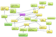 |
503 KB | Amanda | Network respresentation of issues/stakeholders for analysis of the Ilisu Dam Project in Turkey by Maria E. Martinez Murillo C. and Mark Rafferty Originally prepared in conjunction with WD III Seminar (Tufts University) course requirements. | 1 |
| 11:53, 13 June 2012 | Nicoll tigris fig3.jpg (file) | 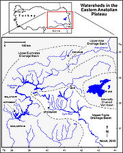 |
368 KB | Amanda | screen resolution | 1 |
| 09:59, 6 June 2012 | Wra wsa wang delangelis 2012.jpg (file) | 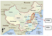 |
317 KB | Amanda | Figure 6 Water Source and Receiving Area of MRP (Map is from [http://www.sacu.org]) annotations added by Wang and DeAngelis to source map available online at sacu.org Base map used in good faith under assumptions of fair use exemption. | 1 |
| 09:39, 6 June 2012 | MRP case provinces.jpg (file) |  |
360 KB | Amanda | 18 Water Quality Control Zone in Danjiangkou Reservoir Watershed in three provinces Water Pollution Control & Soild and Water Conservation Plan Drafting Committee Water Pollution Control & Soil and Water Conservation Plan of Danjiangkou Reservoir and Up | 1 |
| 09:27, 6 June 2012 | Satellite of MRP region.jpg (file) |  |
285 KB | Amanda | Public Domain Satellite Image Screenshot. Labelled by Rose Wang and Kelly DeAngelis, 2012 | 1 |
| 09:10, 6 June 2012 | MRP zones image.jpg (file) |  |
271 KB | Amanda | Adapted from Water Pollution Control & Soild and Water Conservation Plan Drafting Committee Water Pollution Control & Soil and Water Conservation Plan of Danjiangkou Reservoir and Upstream. (2005). Base image used without permission under good faith use | 1 |
| 08:24, 6 June 2012 | Structure of china govt wang deangelis 2012.jpg (file) | 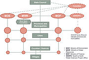 |
307 KB | Amanda | Political Structure of Chinese Government Developed for Middle Route Project Case Study Rose Wang and Kelly DeAngelis 2012. | 1 |
| 08:21, 6 June 2012 | River project watershed Zhang2009.jpg (file) | 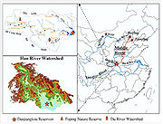 |
456 KB | Amanda | Image from: Zhang, Q., Xu, Z., Shen, Z., Li, S. & Wang, S. The Han River watershed management initiative for the South-to-North water transfer project (Middle Route) of China. ''Environmental monitoring and assessment'' 148, 369–377 (2009). Used to des | 1 |
 First page |
 Previous page |
 Next page |
 Last page |


