Addressing Declining Groundwater Supply in Umatilla County, Oregon, USA
| Geolocation: | 45° 40' 19.47", -118° 47' 18.9481" |
|---|---|
| Total Population | 75,88975,889,000,000 millionmillion |
| Total Area | 2,5202,520 km² 972.972 mi² km2 |
| Climate Descriptors | Semi-arid/steppe (Köppen B-type), Arid/desert (Köppen B-type), Continental (Köppen D-type), Dry-summer, temperate |
| Predominent Land Use Descriptors | agricultural- cropland and pasture, conservation lands, forest land, rangeland, religious/cultural sites |
| Important Uses of Water | Agriculture or Irrigation, Domestic/Urban Supply, Other Ecological Services, Recreation or Tourism |
| Water Features: | Umatilla River |
Contents
Summary
Umatilla County Critical Groundwater Areas, Umatilla County, Oregon, USA
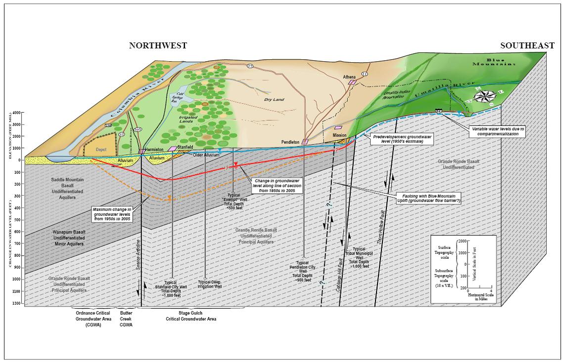
Since the late 1950s the decline of groundwater within Umatilla County, Oregon has been approaching 400 to 500 feet within the deep basalt aquifers underlying the Umatilla Basin, primarily due to withdrawals for public drinking supplies and irrigation for agriculture. Agricultural irrigation, public drinking supply, and Tribal use are the main uses of water within the region. Here we found that the lack of funding from state and federal governments for groundwater resource management led to the development of a community based taskforce responsible for short-term and long-term management of surface and ground based water resources utilizing collaborative learning skills and adaptive management to drive policy decisions.
Natural, Historic, Economic, Regional, and Political Framework
Since the late 1950s the decline of groundwater within Umatilla County, Oregon has been approaching 400 to 500 feet within the deep basalt aquifers underlying the Umatilla Basin, primarily due to withdrawals for public drinking supplies and irrigation for agriculture. Agricultural irrigation, public drinking supply, and Tribal use are the main uses of water within the region. Here we found that the lack of funding from state and federal governments for groundwater resource management led to the development of a community based taskforce responsible for short-term and long-term management of surface and ground based water resources utilizing collaborative learning skills and adaptive management to drive policy decisions.
Core questions regarding this case are:
- How to recover and mitigate drawdown effects from consumptive use within the state-designated Critical Groundwater Areas (CGAs) that will ensure equitable distribution and preserve the quality of groundwater?
- How to manage individual well users tapping the groundwater stored in the aquifer who live outside of urban growth boundaries?
- How to maintain water flows and temperature necessary to sustain life and biodiversity of species important to Tribal culture in rivers and streams that are hydraulically connected to groundwater.
The take away message from this case is that developing a community based management plan regarding a common resource requires patience. The collaborative learning investment will take time to produce the desired results in which equitable distribution of the resource over time and space is brought to fruition. The dedication to public involvement and outreach is providing the gradual foundation of trust between previously antagonistic stakeholders, which is gradual and not hasty. This particular case is still technically developing, even after approximately 5 years.
Figure 1. Block diagram of Umatilla Basin hydrogeology. The red and orange lines depict the change in water level across the basin since the 1950s.Water level declines in the basin range from about 100 feet near Pendleton to over 200 feet near Hermiston. Elsewhere in the basin water levels have declined between 400 and 500 feet [1]
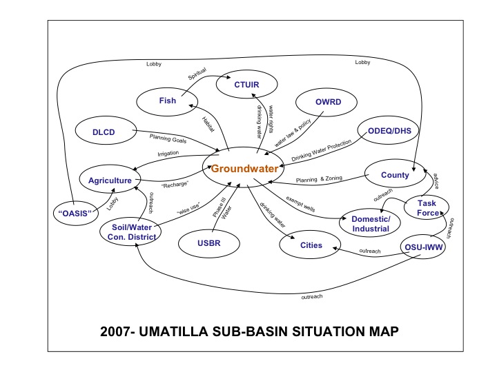
Figure 2. Preliminary depiction of stakeholders and linkages for the groundwater situation in the Umatilla Basin, Northwestern US. “OASIS” was a proposed project to divert water from the Columbia River. DLCD denotes the Oregon Department of Land and Conservation and Development. USBR is the US Bureau of Reclamation. OWRD is the Oregon Water Resources Department. CTUIR is the Confederated Tribes of the Umatilla Indian Reservation. ODEQ/DHS are the Oregon Department of Environmental Quality and the Department of Human Services. OSU-IWW is the Oregon State University, Institute for Water and Watersheds. [1]
Issues and Stakeholders
Water Supply with Competing Purposes
NSPD: Water Quantity, Water Quality, Ecosystems, Governance, Values and Norms
Stakeholder Types: Federated state/territorial/provincial government, Sovereign state/national/federal government, Local Government, Environmental interest, Industry/Corporate Interest, Community or organized citizens, Cultural Interest
Groundwater declines approaching 400 to 500 feet in the deep basalt aquifers underlying the Umatilla Basin (Oregon) in the Northwestern United States have occurred over the past 50 years due to intensive exploitation for public drinking water supplies and agricultural irrigation. The deep basalt aquifer is “shared” by Washington and Oregon including lands ceded by and reserved for the Confederated Tribes of the Umatilla Indian Reservation (CTUIR).
Stakeholders:
- U.S. Bureau of Reclamation
- Confederated Tribes of Umatilla Indian Reservation (CTUIR)
- Agriculture
- Municipalities
- Umatilla County Commissioners
- Oregon Water Resources Department
- Critical Groundwater Task Force
Analysis, Synthesis, and Insight
Individuals may add their own Analysis, Synthesis, and Insight (ASI) to a case. ASI sub-articles are protected, so that each contributor retains authorship and control of their own content. Edit the case to add your own ASI.
Learn moreASI:Umatilla County Critical Groundwater Task Force: Community-Based Approaches to Conflict Management
Contributed by: Aaron T. Wolf, Joshua T. Newton, Matthew Pritchard (last edit: 12 February 2013)
Key Questions
Integration across Sectors: How can consultation and cooperation among stakeholders and development partners be better facilitated/managed/fostered?
Selection of Stakeholders: the Critical Groundwater Areas primarily are located within the western portion of Umatilla County and the Planning Commission recognized that basin-wide water use needed to be addressed before any plans were developed. The members of the Task Force were chosen based upon their respective geographic areas rather than vocational, urban, or Tribal designations. Members were selectively chosen by the Board of Commissioners based upon level of commitment to resolve the water management issue, not to represent vested interests or groups.
Task Force agreed upon a methodology: after the Task Force was created, they based their public involvement/outreach strategy loosely along the lines of the principles of Collaborative Learning, which was designed at Oregon State University.(Daniels, S. E., & Walker, G. B. 2001). This methodology utilizes systems thinking processes to structure conflict management and foster alternative dispute resolution, which is useful in broad natural resource situations with a variety of stakeholder involvement.
- ^ 1.0 1.1 Todd Jarvis. 2010.Community-Based Approaches to Conflict Management: Umatilla County Critical Groundwater Areas, Umatilla County, Oregon, USA. IUCN: http://cmsdata.iucn.org/downloads/northwestern.pdf
| Area | 2,520 km² (972.972 mi²) + |
| Climate | Semi-arid/steppe (Köppen B-type) +, Arid/desert (Köppen B-type) +, Continental (Köppen D-type) +, Dry-summer + and temperate + |
| Geolocation | 45° 40' 19.47", -118° 47' 18.9481"Latitude: 45.672075 Longitude: -118.7885967 + |
| Issue | Water Supply with Competing Purposes + |
| Key Question | How can consultation and cooperation among stakeholders and development partners be better facilitated/managed/fostered? + |
| Land Use | agricultural- cropland and pasture +, conservation lands +, forest land +, rangeland + and religious/cultural sites + |
| NSPD | Water Quantity +, Water Quality +, Ecosystems +, Governance + and Values and Norms + |
| Population | 75,889,000,000 million + |
| Stakeholder Type | Federated state/territorial/provincial government +, Sovereign state/national/federal government +, Local Government +, Environmental interest +, Industry/Corporate Interest +, Community or organized citizens + and Cultural Interest + |
| Water Feature | Umatilla River + |
| Water Use | Agriculture or Irrigation +, Domestic/Urban Supply +, Other Ecological Services + and Recreation or Tourism + |
| Has subobjectThis property is a special property in this wiki. | Addressing Declining Groundwater Supply in Umatilla County, Oregon, USA + |
 This is the


