File list
This special page shows all uploaded files.
| Name | Thumbnail | Size | User | Description | Versions | |
|---|---|---|---|---|---|---|
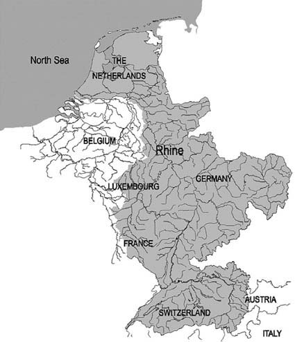
| 13:00, 15 May 2014 | Rhine River Basin.jpg (file) |  |
46 KB | Jcheung6 | 1 | |
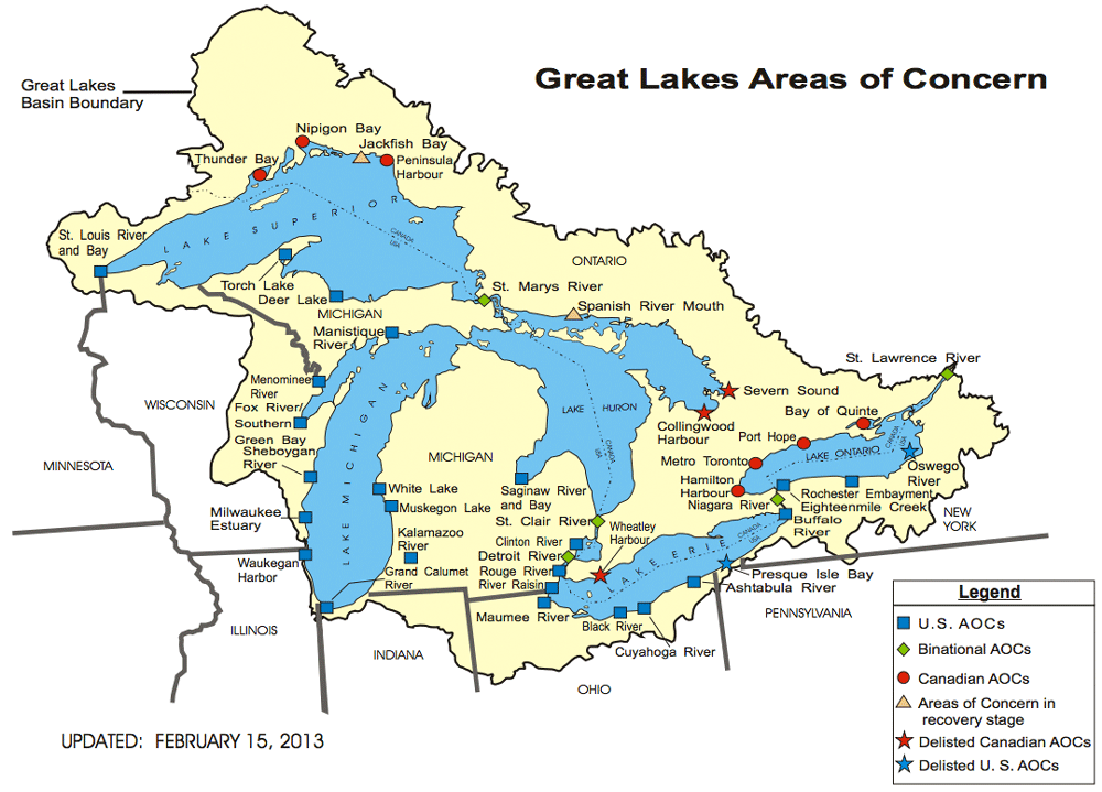
| 10:31, 16 May 2014 | GreatLakes-AOC-USEPA.png (file) |  |
151 KB | Amanda | adapted from - http://www.epa.gov/greatlakes/aoc/images/aoc-glbasin-map-20130215.pdf "The U.S.-Canada Great Lakes Water Quality Agreement (Annex 2 of the 1987 Protocol) defines AOCs as "geographic areas that fail to meet the general or specific object... | 1 |
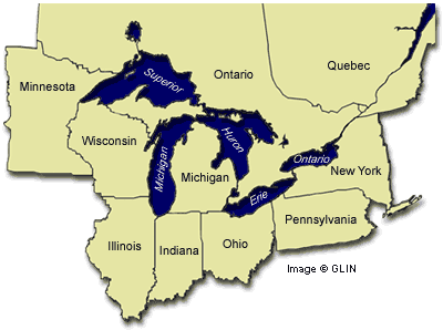
| 11:04, 16 May 2014 | Great Lakes Basin Map.gif (file) |  |
17 KB | Amanda | GLIN map of Great Lakes region with adjacent U.S. States and Candaian provinces, highlighting drainage basin http://www.great-lakes.net/lakes/ | 1 |
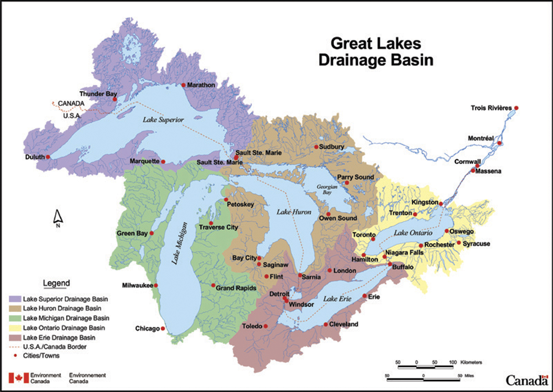
| 11:44, 16 May 2014 | Great Lakes Drainage Basin Env Canada.jpg (file) |  |
852 KB | Amanda | This map depicts the sub-basins within the Great Lakes drainage basin. This is a reproduction of a map produced by Environment Canada. It is a copy of an official work that is published by the Government of Canada and that the reproduction has not bee... | 1 |
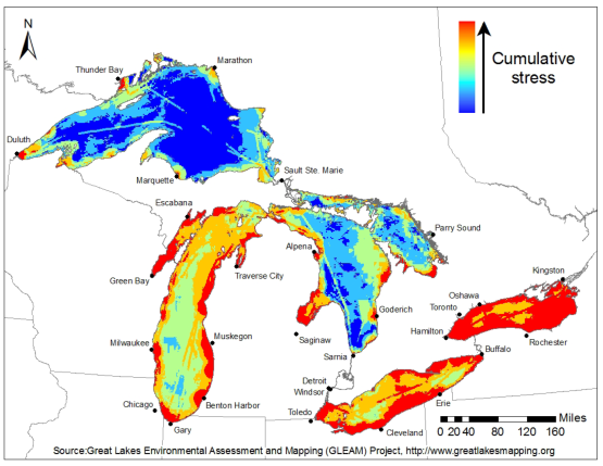
| 11:56, 16 May 2014 | GLEAM Great Lakes Environmental Stress Map.png (file) |  |
169 KB | Amanda | Great Lakes Environmental Stress Map, 2012. This is a product of the Great Lakes Environmental Assessment and Mapping (GLEAM) Project. http://www.greatlakesmapping.org/ Additional maps, descriptive documents, and other resources may be found here: ... | 1 |
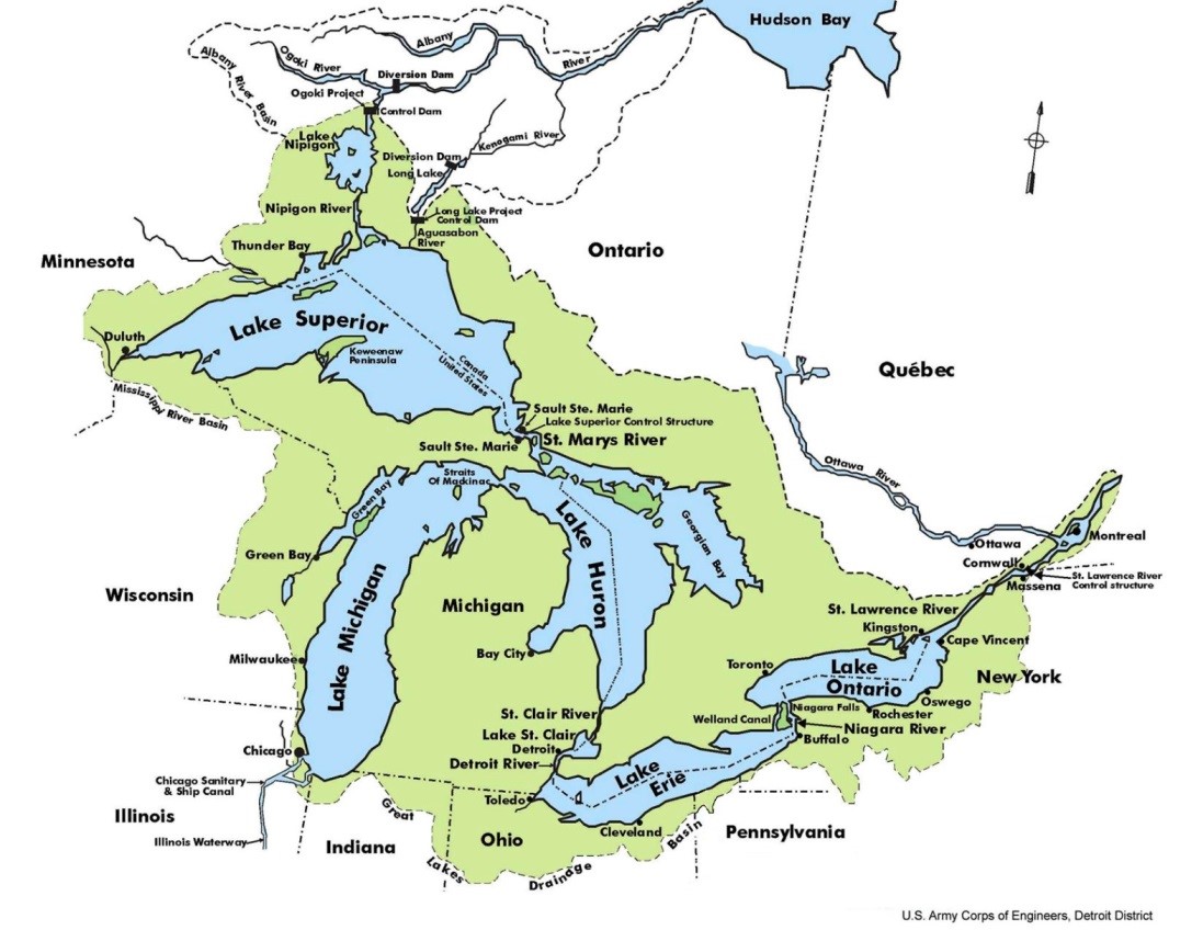
| 18:53, 21 May 2014 | Great Lakes Overview.jpeg (file) |  |
171 KB | B Finney | Taken from the US Army Corp of Engineers website: http://www.lrd-wc.usace.army.mil/LRD-WM/GreatLakes/GreatLakes.html | 1 |
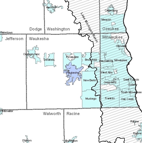
| 19:11, 21 May 2014 | Waukesha GL.jpg (file) |  |
95 KB | B Finney | This image was taken from: http://dnr.wi.gov/topic/wateruse/waukeshadiversionapp.html | 1 |
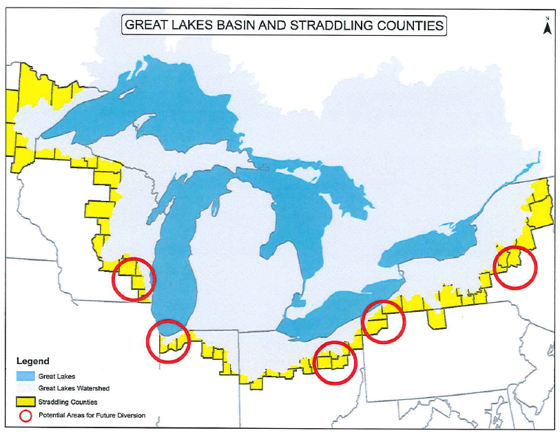
| 19:16, 21 May 2014 | US Straddling Counties.png (file) |  |
648 KB | B Finney | This image was taken from a presentation by the Waukesha Water Utility: http://www.ci.waukesha.wi.us/c/document_library/get_file?uuid=7480f775-3981-46a7-a7c0-c1f8579227b1&groupId=10113 | 1 |
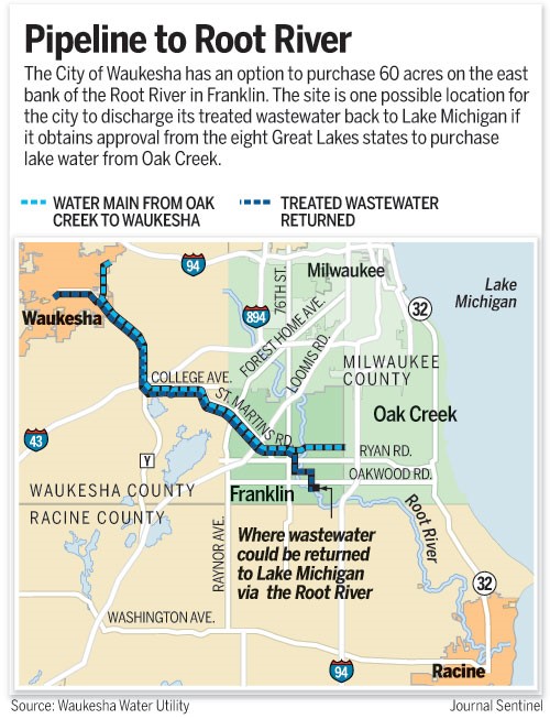
| 19:20, 21 May 2014 | Root River Pipeline.jpg (file) |  |
101 KB | B Finney | This image was taken from: http://www.jsonline.com/news/waukesha/waukesha-buys-option-on-land-for-root-river-discharge-ce8jmke-189591171.html | 1 |
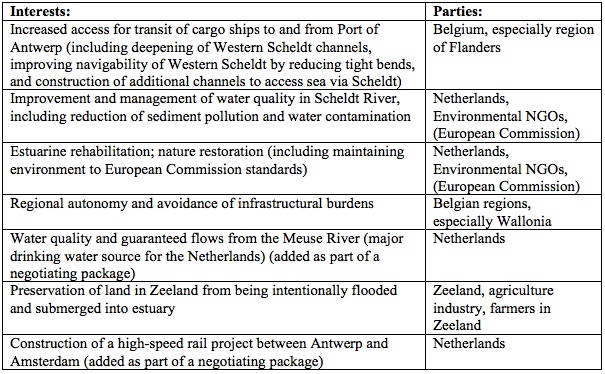
| 18:14, 22 May 2014 | Stakeholder interests table.jpg (file) |  |
146 KB | Elizabeth | 1 | |
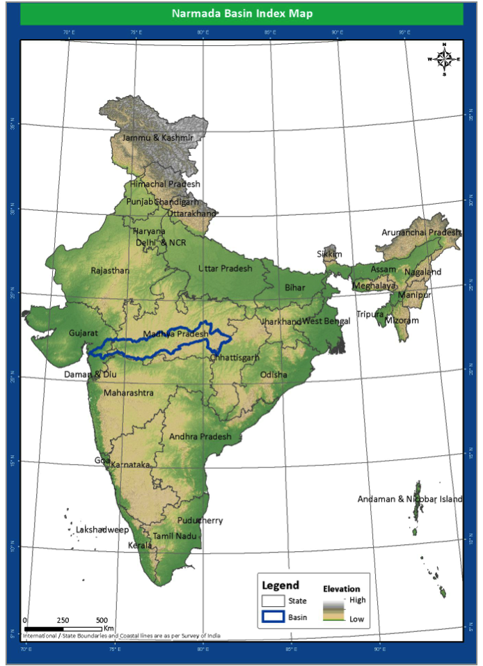
| 21:41, 23 May 2014 | Location.png (file) |  |
567 KB | Rachel | Location of the Narmada River Basin | 1 |
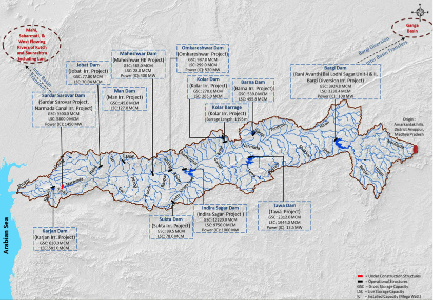
| 21:41, 23 May 2014 | Major projects.png (file) |  |
837 KB | Rachel | Major Water Resource Projects in the Narmada Basin | 1 |
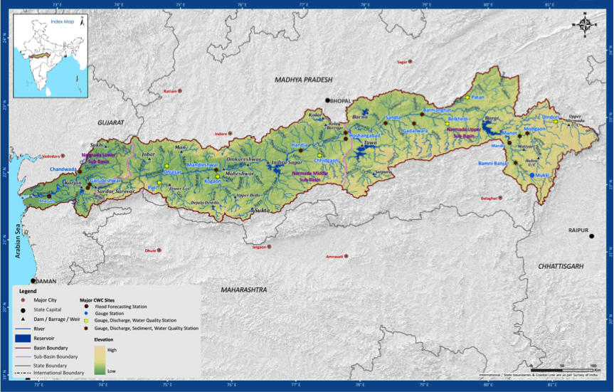
| 21:42, 23 May 2014 | Drainage.png (file) |  |
720 KB | Rachel | Narmada Basin and Sub-basin Drainage, incl. Reservoirs (submergence areas) | 1 |
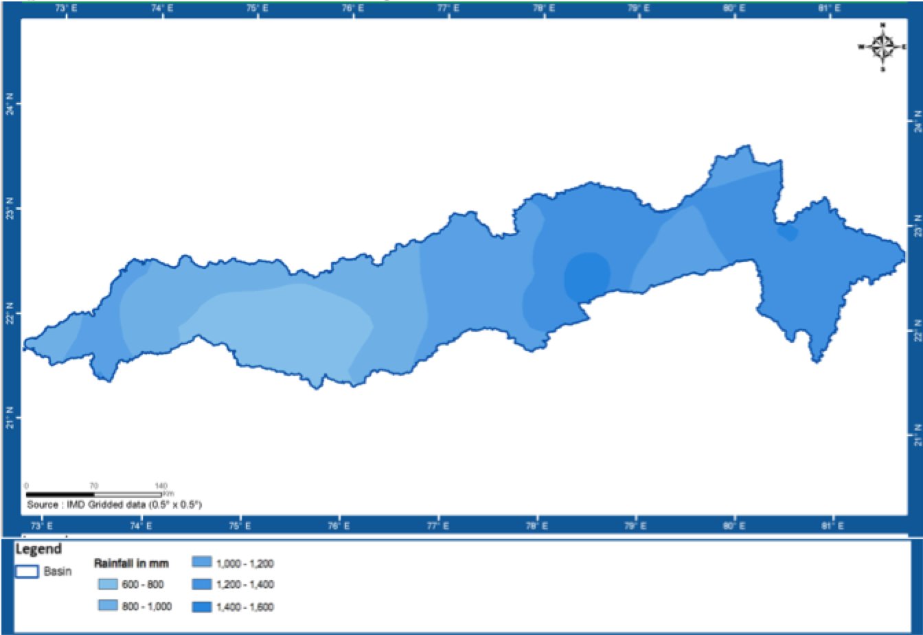
| 21:43, 23 May 2014 | Rainfall.png (file) |  |
207 KB | Rachel | Narmada Basin Annual Average Rainfall | 1 |
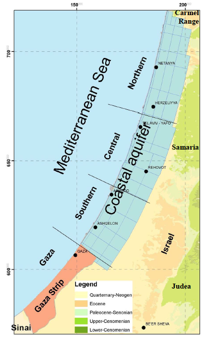
| 09:20, 26 June 2014 | Coastal-Aquifer-Extent.png (file) |  |
210 KB | Amanda | low-res Image showing the extent of the Coastal Aquifer. This image is figure 17 in : Weinberger, G. et al. 2012. The Natural Water Resources between the Meditteranean Sea and the Jordan River. Israel Hydrologic Service. Jerusalem. online: http://www.... | 1 |
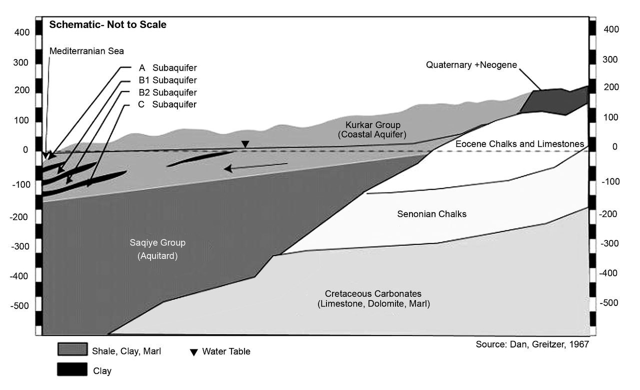
| 10:06, 26 June 2014 | Coastal-Aquifer-Schematic.png (file) |  |
393 KB | Amanda | Geologic Schematic of the Coastal Aquifer from: Greitzer, D. J. Dan. 1967, The effect of soil landscape and quaternary geology on the distribution of saline and freshwater aquifers in the Coastal Plain of Israel, Water Planning for Israel, Tel Aviv, L... | 1 |
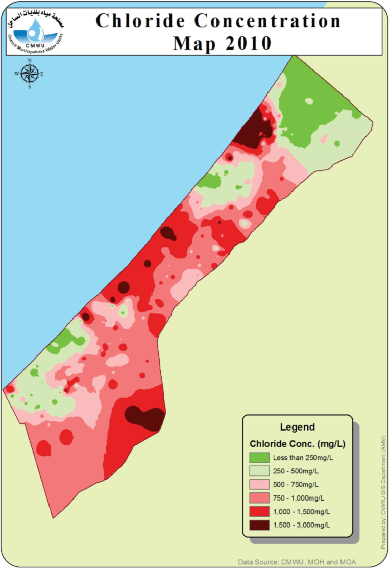
| 13:00, 26 June 2014 | CMWU-2010-chloride.png (file) |  |
280 KB | Amanda | From CMWU Annual Report 2010, Coastal Municipalties Water Utility, Palestine, 2011. Online at: http://www.cmwu.ps/en/yreports.php?view=17 | 1 |
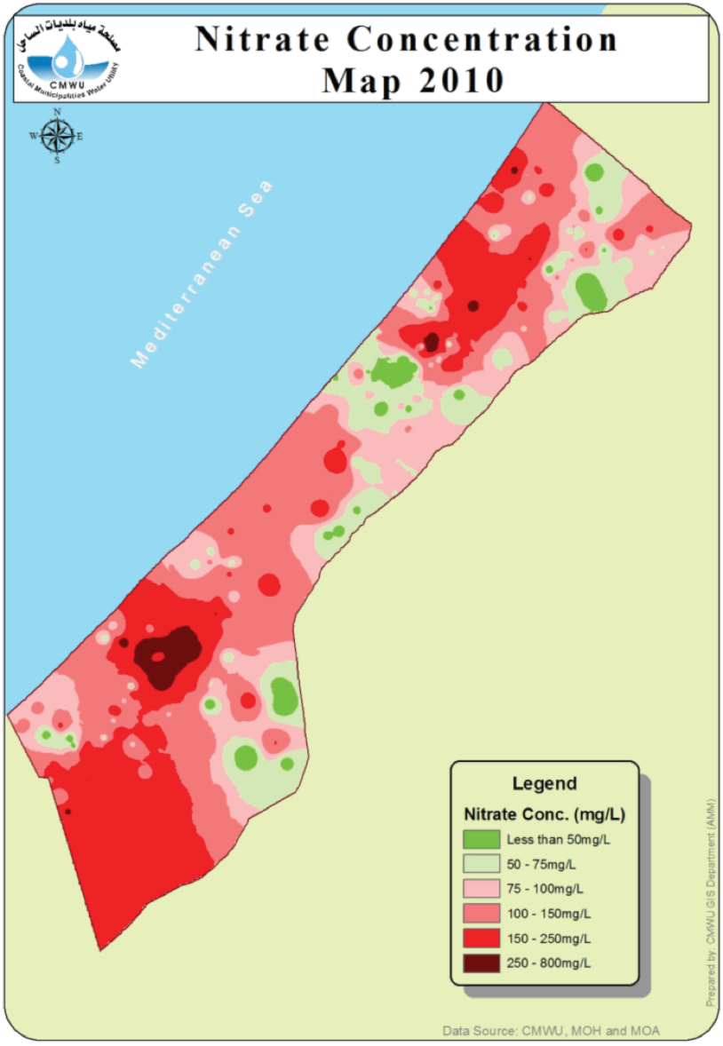
| 13:01, 26 June 2014 | CMWU-2010-nitrate.png (file) |  |
313 KB | Amanda | From CMWU Annual Report 2010, Coastal Municipalities Water Utility, Palestine, 2011. Online at: http://www.cmwu.ps/en/yreports.php?view=17 | 1 |
| 09:57, 29 July 2014 | Site-main-slide02.png (file) | 103 KB | Amanda | This is a descriptive slide used on the main page. | 1 | |
| 09:58, 29 July 2014 | Site-main-slide01.png (file) | 25 KB | Amanda | This image is used on the main page javascript slide show | 1 | |
| 14:34, 31 July 2014 | Buesser, Christine - Gaza Water Management Presentation MIT May 2014 external use.pdf (file) | 1.61 MB | Amanda | Slides from a presentation by Christine Buesser, at MIT for the 2014 Spring Semester Water Diplomacy course, May 15, 2014 Images within the presentation are subject to the copyright of their original source. This file is included here because it i... | 1 | |
| 13:54, 1 August 2014 | Site-main-slide03-01.png (file) | 115 KB | Amanda | A slide for the main paige to promote the AquaPedia RFP | 1 | |
| 13:54, 1 August 2014 | Site-main-slide04-01.png (file) | 120 KB | Amanda | A slide for the main paige to promote the AquaPedia RFP | 1 | |
| 07:32, 26 October 2014 | Nile GERD AHD hydrology.pdf (file) | 3.2 MB | Tesfay | Recently published Modeling of two cascade and cross-border dams; the impact of the Grand Ethiopian Renascence Dam on the Egyptian Aswan Dam. An article focused on the Nile basin water management. | 1 | |
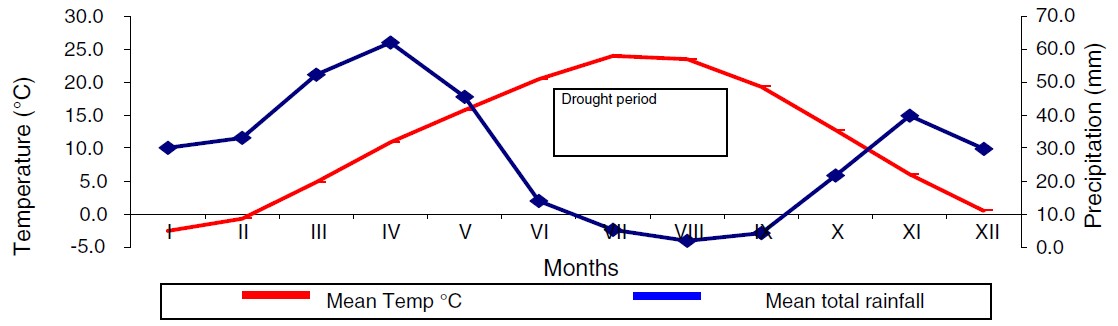
| 10:40, 28 January 2015 | 1.jpg (file) |  |
62 KB | Zarghami | Ombrothermic diagram of Urmia station by using Emberger method, and precipitation and potential evapotranspiration, Urmia station (Delju et al 2013) | 1 |
| 10:42, 28 January 2015 | Urmia1.jpg (file) |  |
62 KB | Zarghami | Ombrothermic diagram of Urmia station by using Emberger method, and precipitation and potential evapotranspiration, Urmia station (Delju et al 2013) | 1 |
| 10:42, 28 January 2015 | Urmia2.jpg (file) |  |
70 KB | Zarghami | 1 | |
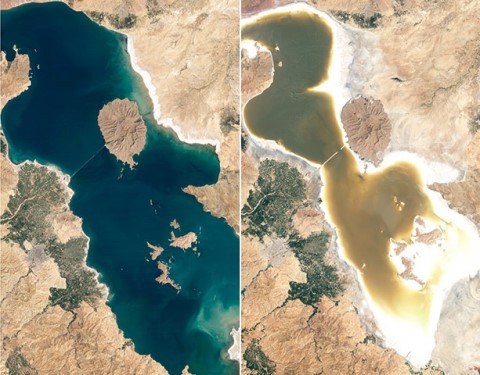
| 10:44, 28 January 2015 | Urmia3.jpg (file) |  |
60 KB | Zarghami | Urmia Lake desiccation in recent 20 years | 1 |
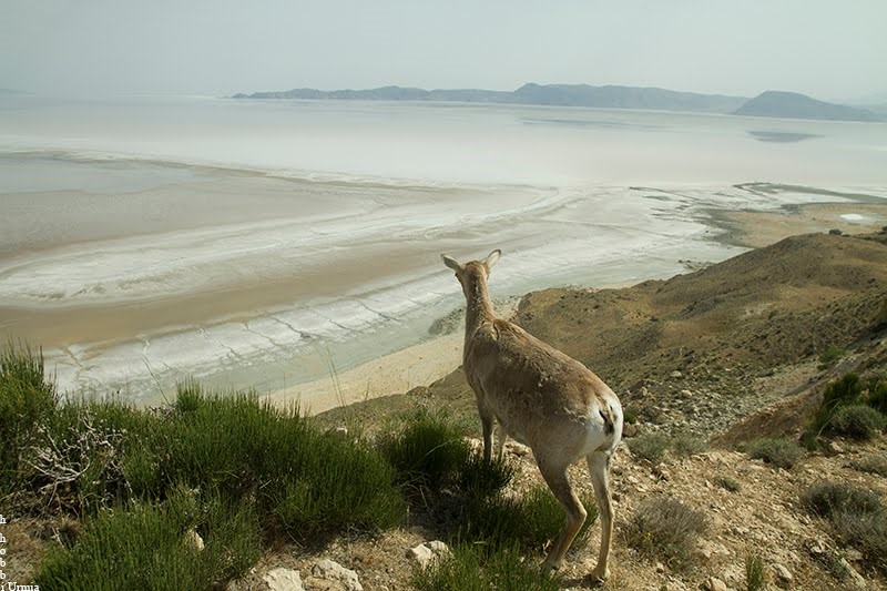
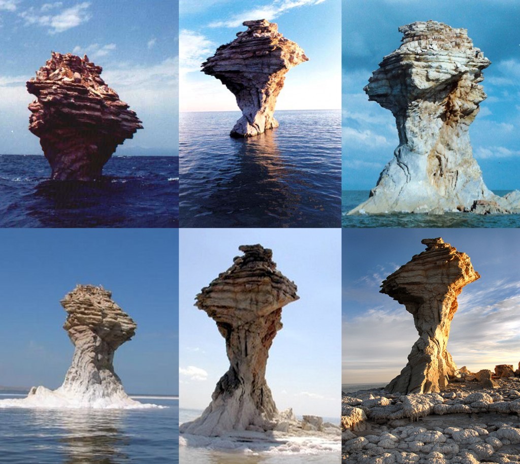
| 10:45, 28 January 2015 | Urmia4.jpg (file) |  |
119 KB | Zarghami | The mammals facing water shortages in the Islands within the Lake and may escape from their environment (Hobbi, 2014) | 1 |
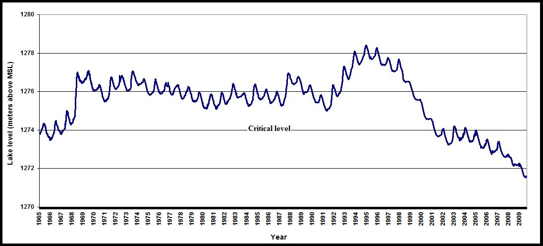
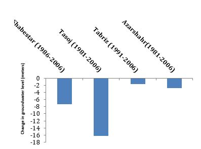
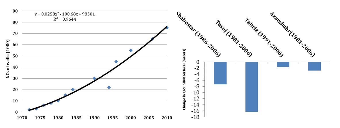
| 10:46, 28 January 2015 | Urmia5.jpg (file) |  |
63 KB | Zarghami | The annual stage of Urmia Lake (Zarghami 2010) | 1 |
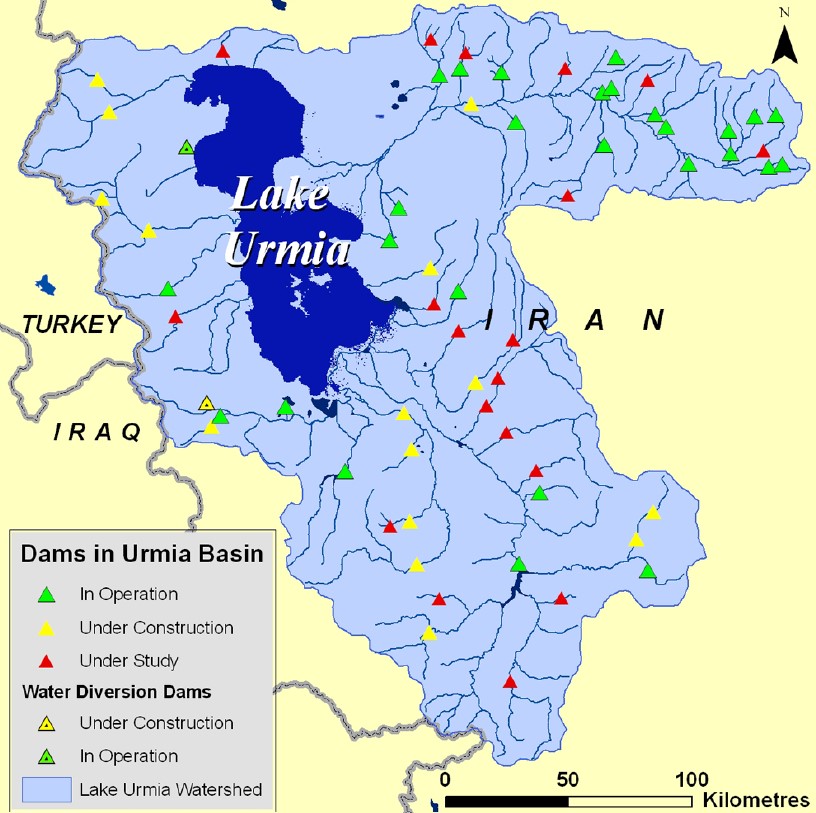
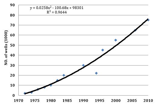
| 10:51, 28 January 2015 | Urmia6.jpg (file) |  |
159 KB | Zarghami | The locations of the dams in operation, construction and investigation (CIWP, 2014) | 1 |
| 10:52, 28 January 2015 | Urmia7.jpg (file) |  |
224 KB | Zarghami | The desiccation of Urmia Lake and its scenic impact (http://www.oxu.ca/lake/, accessed 12-06-2014) | 1 |
| 13:08, 28 January 2015 | Urmia8.JPG (file) |  |
29 KB | Zarghami | 2 | |
| 13:08, 28 January 2015 | Urmia9.JPG (file) |  |
19 KB | Zarghami | 2 | |
| 13:12, 28 January 2015 | Urmia8.jpg (file) |  |
29 KB | Zarghami | 1 | |
| 13:55, 28 January 2015 | Urmia11.JPG (file) |  |
53 KB | Zarghami | 1 | |
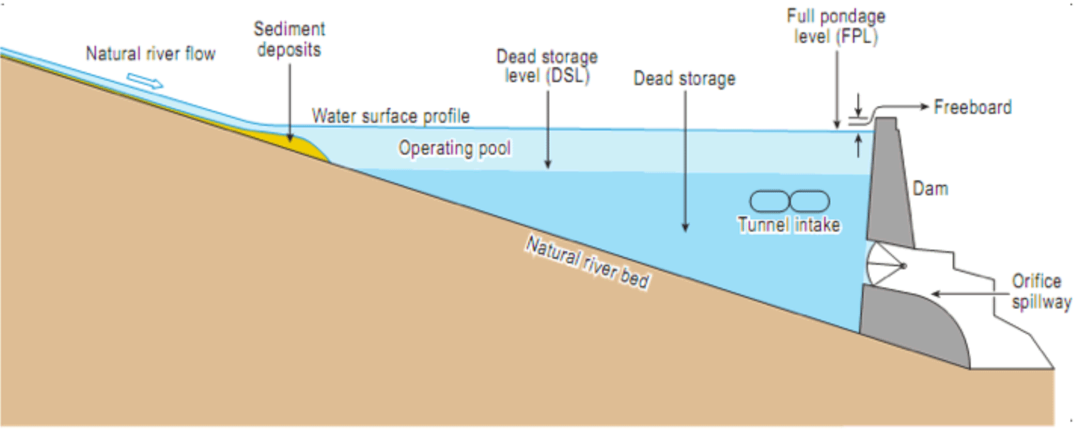
| 11:11, 29 January 2015 | Schematic side view typical dam.png (file) |  |
67 KB | Ashfaqm | A generic schematic showing the side view of a typical dam with low-level outlets. This graphic is from the Court of Arbitration (CoA) 2013a. Partial Award Indus Waters Kishenganga Arbitration (Pakistan v. India) (18 February). Documents linked for do... | 1 |
| 08:09, 30 January 2015 | Hydro-diplomacy to Address the Transboundary Water Issues between India and Pakistan.pdf (file) | 3.1 MB | Ashfaqm | PDF slide version of presentation: Mahmoud, A. 2014. Hydro-diplomacy to Address the Transboundary Water Issues between India and Pakistan Presentation from IUCN 2nd National Consultative Workshop on Pakistan Water Issues (3 June 2014) Available from:... | 1 | |
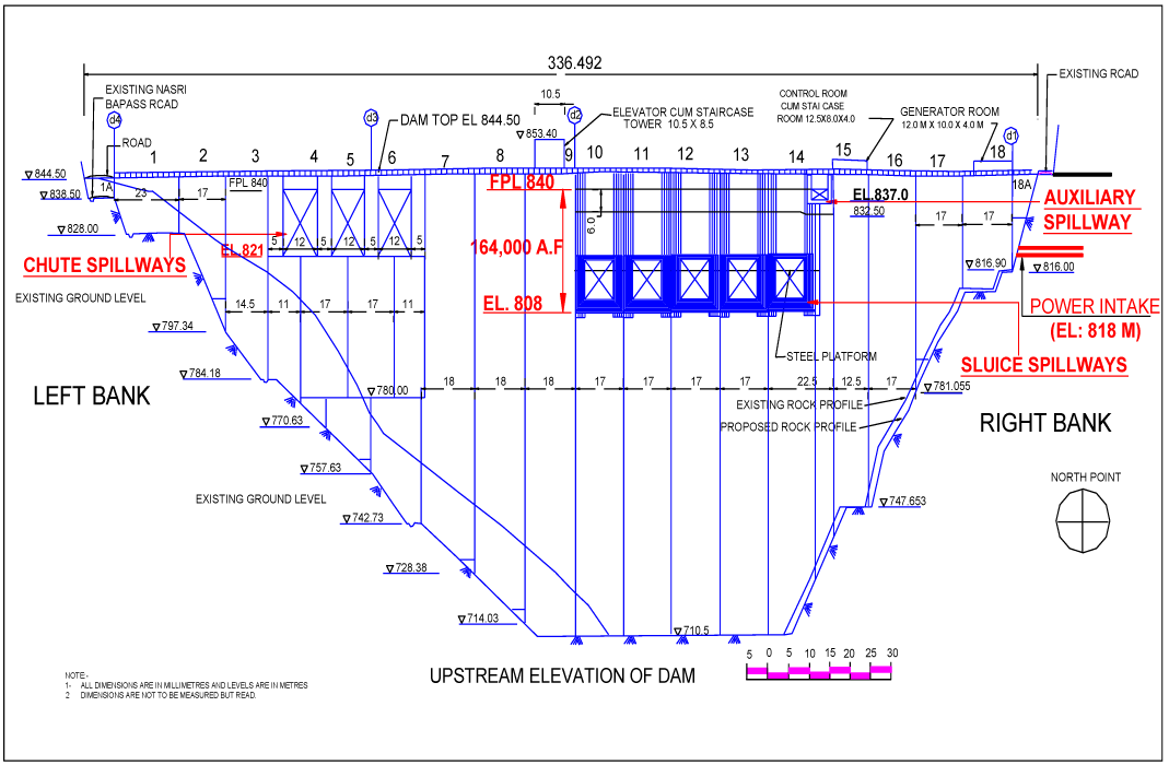
| 08:30, 30 January 2015 | Upstream-Elevation-of-Baglihar-Dam.png (file) |  |
45 KB | Ashfaqm | Schematic depicting upstream elevation of the Baglihar Dam. Original Source was cited as Pakistan Commission for Indus Waters, but it is published in Mahmoud, A. 2014. Hydro-diplomacy to Address the Transboundary Water Issues between India and Pakist... | 1 |
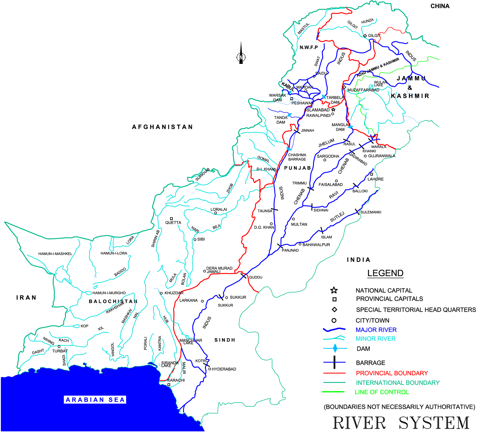
| 08:46, 30 January 2015 | Map of Indus Basin.png (file) |  |
180 KB | Ashfaqm | Map of Indus River Sysetm Figure 2.2 in Ministry of Water and Power. 2002. Pakistan Water Sector Strategy Report v2, p19. Available online: http://waterinfo.net.pk/sites/default/files/knowledge/Pakistan%20Water%20Sector%20Strategy%20-%20Vol%202.pdf | 1 |
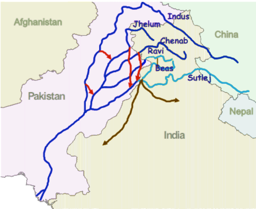
| 09:10, 30 January 2015 | Indus-River-Linking-Project-Pakistan.png (file) |  |
67 KB | Ashfaqm | From World Bank (2005) Pakistan Country Water Resources Assistance Strategy Water Economy: Running Dry. Report No. 34081-PK. Washington, DC: World Bank. Available Online http://documents.worldbank.org/curated/en/2005/11/6492396/pakistan-country-water... | 1 |
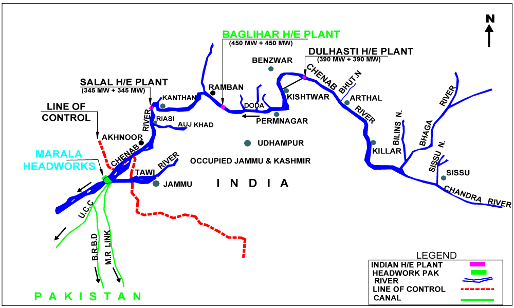
| 09:15, 30 January 2015 | Baglihar Dam on Chenab river.png (file) |  |
36 KB | Ashfaqm | image included in slide 11 from Mahmoud, A. 2014. Hydro-diplomacy to Address the Transboundary Water Issues between India and Pakistan Presentation from IUCN 2nd National Consultative Workshop on Pakistan Water Issues (3 June 2014) Available from: htt... | 1 |
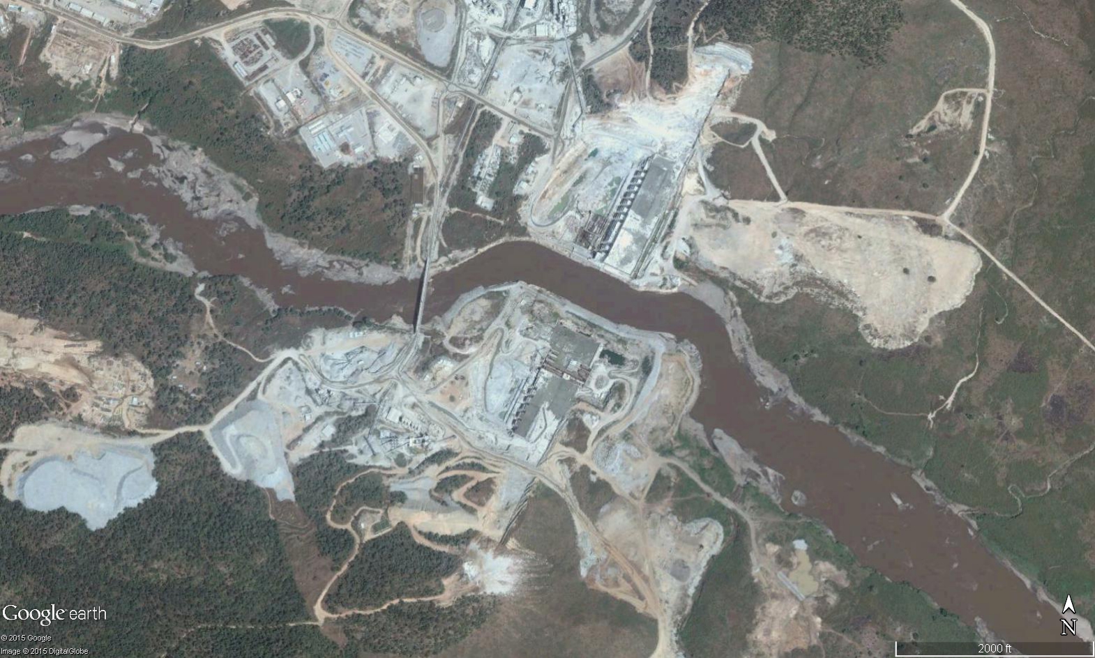
| 16:26, 21 December 2015 | GERD Site.jpg (file) |  |
895 KB | Agustinbotteron | Site of construction of the Grand Ethiopian Renaissance Dam (GERD), Ethiopia. | 1 |
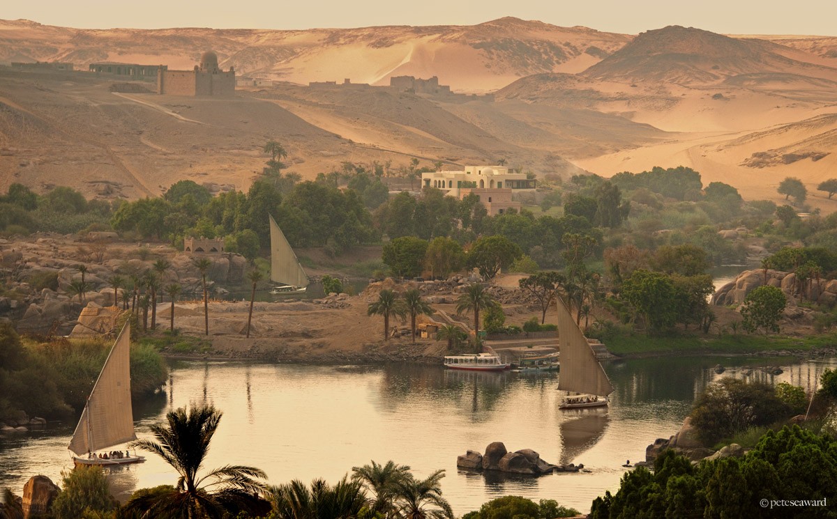
| 17:15, 21 December 2015 | Aswan02.jpg (file) |  |
245 KB | Agustinbotteron | Source:http://www.peteseaward.com/_themes/pete_seaward/watermark.php?photo=110_main_large.jpg&dir=galleries | 1 |
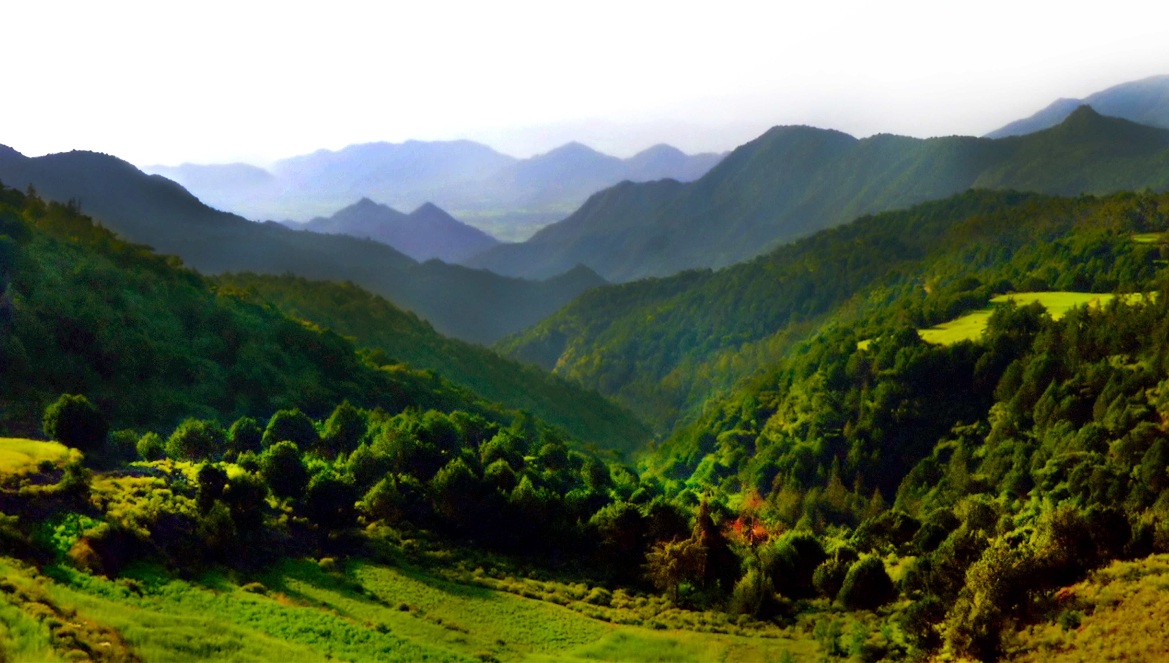
| 17:17, 21 December 2015 | Ethiopia Highlands.jpg (file) |  |
8.05 MB | Agustinbotteron | 1 | |
| 17:21, 21 December 2015 | Khartoum02.jpg (file) |  |
184 KB | Agustinbotteron | 1 | |
| 17:21, 21 December 2015 | Sudd.jpg (file) |  |
155 KB | Agustinbotteron | 1 | |
| 17:28, 21 December 2015 | Cairo02.jpg (file) |  |
1.18 MB | Agustinbotteron | 1 | |
| 16:58, 18 January 2016 | Salton Pano.jpg (file) | 9.11 MB | JRozek | Source: https://www.flickr.com/photos/on_earth/14523087446 License: https://creativecommons.org/licenses/by/2.0/ | 1 | |
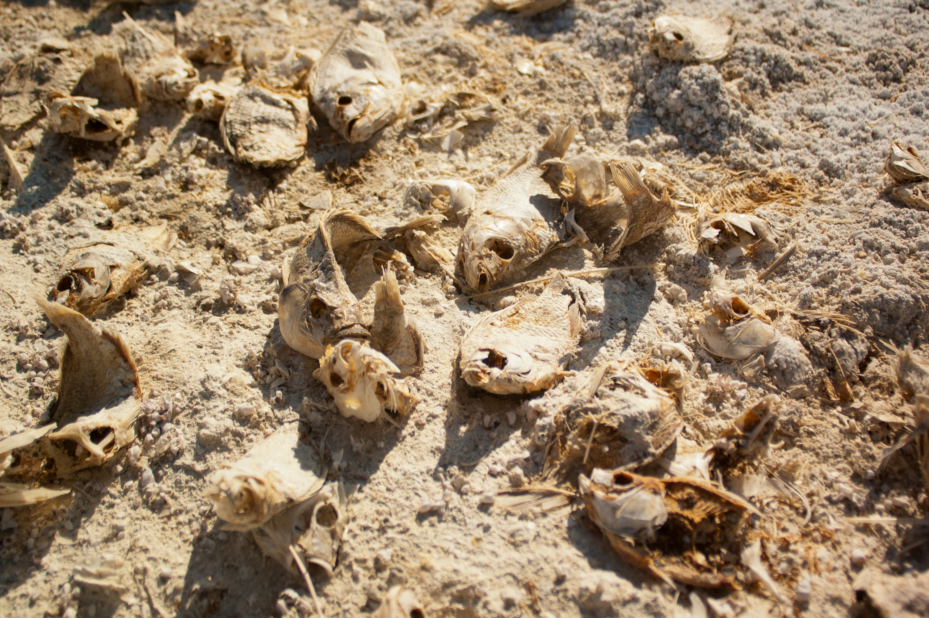
| 17:02, 18 January 2016 | DeadFish.jpg (file) |  |
5.02 MB | JRozek | Source: https://www.flickr.com/photos/hermitsmoores/6578846137/ License: https://creativecommons.org/licenses/by-nc-sa/2.0/ | 1 |
First page |
Previous page |
Next page |
Last page |


