Water Quality Control of the South-to-North Water Diversion (SNWD) Middle Route Project (MRP)
| Geolocation: | 32° 36' 0", 111° 35' 60" |
|---|---|
| Total Population | 11.9811,980,000 millionmillion |
| Total Area | 9500095,000 km² 36,679.5 mi² km2 |
| Climate Descriptors | temperate |
| Predominent Land Use Descriptors | agricultural- cropland and pasture, industrial use, urban |
| Important Uses of Water | Agriculture or Irrigation, Domestic/Urban Supply, Industry - consumptive use, Industry - non-consumptive use |
Contents
Summary
Natural, Historic, Economic, Regional, and Political Framework
Introduction
China’s water resources are extremely unevenly distributed. While the South China Plain is relatively water abundant, the Huang-Huai-Hai (3H) river basins in the North are rather dry. The North China Plain has half of China’s total national area, 45% of total cultivated land and 36% of the total population, but possesses less than 12% of the total water resources1. Per capita annual water availability in the North is about 500 m3 and can fall below 400 m3 in Beijing and Tianjin2. This is much lower than the 1000 m3 per capita threshold of water scarcity defined by the UN. In 1952, the late Chairman Mao first came up with the idea of “borrowing” water from the South to meet the demands of the North. Over the next several decades, scientists and engineers debated about the technical and economic feasibility of Mao’s vision. In 2002, the plan of the magnificent South-to-North Water Division Project (SNWDP), which will divert 44.8 billion cubic meters of water from the Yangtze River Basin to the northern river basins, was approved. It consists of three water division routes that connect the Yangtze River Basin to the other three major river basins: Huang River (Yellow River), Huai River and Hai River. Up to now, the Eastern and Middle Routes are under construction and the Western Route is under planning.
As the construction of the projects proceeds, one question appears on the agenda: will the water delivered to the north be of good quality? If the water quality were too bad, it would increase treatment cost and reduce its economic value. The return on the huge investment made on the planning and construction of the projects would be uncertain. Therefore, “assuring water quality is essential to the success of the SNWDP”, as quoted in many of the recent official Chinese media reports today. This case study will focus on the water quality control on Middle Route, though the analysis and policy recommendations will also apply to the other two routes.
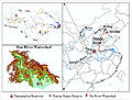
The middle route will be completed by the end of 2014. It is designed to supply 9.7 billion cubic meters of water annually along a 1,432 km canal to Beijing and 20 other municipalities and cities along the route (Figure 1). The route starts from the Danjiangkou Reservoir, which is formed by the impoundment of the convergence of the Han River and the Dan River (Figure 2).
- Stakeholders
- *SNWD Project Office (ministerial level government)
- *Ministry of Environmental Protection, Ministry of Water Resources, Ministry of Finance
- **Henan Province (河南省)
- ***Luoyang City (洛阳市): Luanchuan County (栾川县), Sanmenxia City (三门峡市), Lushi County (卢氏县)
- **Hubei Province (湖北省provincial government)
- ***Xiangyang City (襄阳市): Xiangzhou District Huanglong Town (襄州区,黄龙镇)
- ***Danjiangkou City (丹江口市)
- ***Shangluo City (商洛市): Shangzhou District (商周区), Zhen’an County (镇安县), Zuoshui County (柞水县), Danfeng County (丹凤县), Shangnan County (商南县), Shanyang County (山阳县)
- ***Baoji City (宝鸡市): Taibai County (太白县)
- Stakeholders
- Stakeholders
- *Water Receiving Area (WRA)
- *Water Source Area (WSA)
- *SNWD Project Office
- ====Issue Analysis====
- ====Issue 1: Government expenditure on water quality related infrastructure projects====
- ====Issue 2: Population affected by water quality control in the water source area====
- ====Issue 3: Costs and benefits sharing between WRA and WSA====
- ====Issue 4: involving stakeholders in decision making process====
- ==Evaluation, Collection and Distribution of PWQS==
- ==Implementing PWQS – the Intervention Point==

To understand the political framework of the topic of interest, we need to first take a look at the political framework of Chinese government system, as shown in Figure 3. The top administrative organization is called the State Council, followed hierarchically by provinces and Municipalities, cities, counties or districts, and villages. There are also Autonomous Regions (e.g. Xinjiang and Tibet), as well as Special Administrative Regions (e.g. Hongkong and Macau), which are at the same level as provinces. Ministries, such as Ministry of Environmental Protection, Ministry of Finance, and Ministry of Water Resources, etc., are executive bodies under the direct lead of the State Council. Departments of similar functions (environmental protection, water resources, etc.) take responsibility at the provincial, city, and even district level; they report to their superior organizations up to ministry level.

As an inter-basin water transfer project, SNWDP involves a number of provinces and municipalities. To coordinate among different provinces, an institutional body – the South-to-North Water Diversion Project Office (SNWD Project Office) was created in 1979 to oversee the planning, design, construction and operation of the SNWDP. A committee led by the Vice Prime Minister sets the goals and policy of the Project Office. The board members of the committee include all relevant ministers, provincial governors, and municipality mayors. There are also sub-offices at the provincial and municipal levels in charge of the construction projects within their jurisdictional boundaries. In short, the central government endorses SNWD Project Office to perform a coordinative role in all issues related to the South-to-North Water Diversion Project.
Water Quality Related Regulation
To assure good water quality the SNWD Project Office created the Reservoir, the Water Pollution Control & Soil and Water Conservation Plan (hereafter referred to as “the Plan”) in 2005. According to the Plan, the Danjiangkou Reservoir and main Han River should achieve water quality of Category II, and the tributaries flowing into Danjiangkou Reservoir should be better than Category III [1]. Eighteen control zones were created at the watershed of the reservoir (Figure 4). These control zones span across Shaanxi, Hubei and Henan Provinces. Three of the eighteen zones are within 5km of the Reservoir peripheral and are therefore defined as the Water Source Area Security Zone. Three zones on the far left side are the sources of Han River. The soil and water conservation in these zones are essential to the water quality in the Reservoir, so together these zones are defined as the Ecological Conservation Zone. The other eleven zones in between are collectively called the Water Quality Impact Zone (Figure 5). The Plan computed the environmental capacity of each control zone, based on the water quality condition of the river stretch in that particular zone. By comparing the current pollution loadings with the environmental capacity of the control zones, the Plan computed the amount of loading reduction needed for each control zone.

The Water Source Area (WSA) of the Middle Route spans across Hubei, Shaanxi and Henan province_ The Water Receiving Area (WRA) includes Beijing, Tianjin, Henan and Hebei provinces (Figure 2)_ Henan province is both WSA and WRA_
Table 1 summarizes the economic indicators for the provinces and municipalities of the water source area and water receiving area_ As the table shows, the GDP per person of Beijing and Tianjin are about three times of the other provinces_ It is obvious from the figure that water source area is generally much poorer than the water receiving area_
Tables 1a and 1b: Economic facts of the Water Source Area (WSA) and Water Receiving Area (WRA) provinces/municipalities source [2]
Table 1a WRA {
Analysis, Synthesis, and Insight
Individuals may add their own Analysis, Synthesis, and Insight (ASI) to a case. ASI sub-articles are protected, so that each contributor retains authorship and control of their own content. Edit the case to add your own ASI.
Learn moreASI:Alternative Solutions to the Water Demand of Northern China
Concerning the ultimate problem of imbalance water demand distribution in the Northern and Southern China, scholars suggest implementations that will further consider China's water sustainability other than water diversion.(read the full article... )
Contributed by: Samuel Hsiao (last edit: 1 August 2013)
ASI:Determining Fair Payment for Ecosystem Services
Payment for Ecosystem Services (PES), a voluntary exchange of a defined environmental service for a fee, has been previously implemented in China there is no consensus on criteria for fair compensation. Planned water quality control actions require capital investments and restrict development options for the water source area. For this reason, the receiving area is expected to compensate the source area for their conservation efforts. How should PES payments be determined?(read the full article... )
Contributed by: Margaret Garcia (last edit: 19 March 2013)
- ^ Water Pollution Control & Soild and Water Conservation Plan Drafting Committee Water Pollution Control & Soil and Water Conservation Plan of Danjiangkou Reservoir and Upstream. (2005).
- ^ The Economist. "Comparing Chinese provinces with countries: All the parities in China". (201AD).at [1]. retrieved May 2012.


