File list
This special page shows all uploaded files.
| Date | Thumbnail | Size | User | Description | Versions | |
|---|---|---|---|---|---|---|
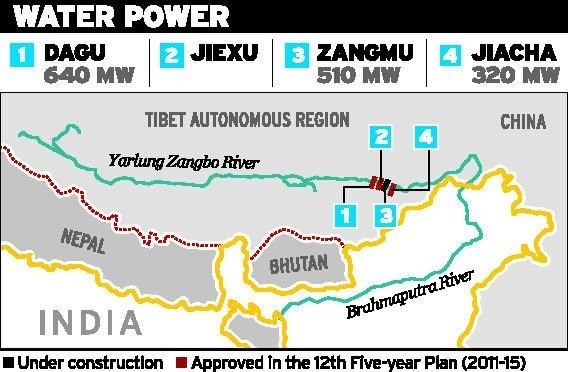
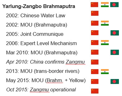
| 16:41, 23 May 2017 | Zangmu Dam and other planned Chinese dams on the Yarlung Zangbo-Brahmaputra.jpg (file) |  |
68 KB | Cindynoe | 1 | |
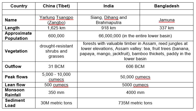
| 16:16, 23 May 2017 | Yarlung Zangbo Brahmaputra key basin statistics country by country.jpg (file) |  |
84 KB | Cindynoe | 1 | |
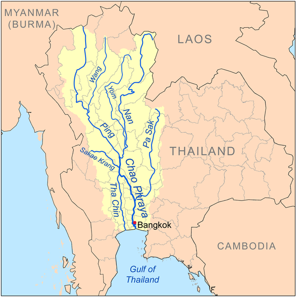
| 22:10, 10 May 2014 | Xx-Chaophrayarivermapxx.png (file) |  |
233 KB | TSP | The Chao Phraya River and its Tributaries Source: http://en.wikipedia.org/wiki/Tributaries_of_the_Chao_Phraya_River | 1 |
| 22:17, 10 May 2014 | Xx-Bhumibol dam front.jpg (file) |  |
132 KB | TSP | Bhumipol Dam Source: http://en.wikipedia.org/wiki/Bhumibol_Dam | 1 |
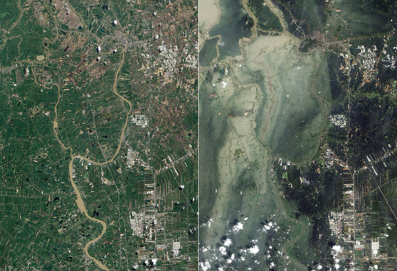
| 22:47, 10 May 2014 | Xx-7.jpg (file) |  |
170 KB | TSP | Satellite photographs showing flooding in Ayutthaya and Pathum Thani Provinces in July 2011 (left, before the flooding October 2011) and October 2011 (right, after the flooding in July) Source: http://en.wikipedia.org/wiki/2011_Thailand_floods | 1 |
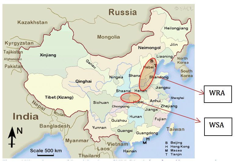
| 09:59, 6 June 2012 | Wra wsa wang delangelis 2012.jpg (file) |  |
317 KB | Amanda | Figure 6 Water Source and Receiving Area of MRP (Map is from [http://www.sacu.org]) annotations added by Wang and DeAngelis to source map available online at sacu.org Base map used in good faith under assumptions of fair use exemption. | 1 |
| 14:13, 16 July 2012 | Wikify icon.png (file) | 3 KB | Amanda | created for AquaPedia. available for use under CC-0 License. http://creativecommons.org/about/cc0 | 1 | |
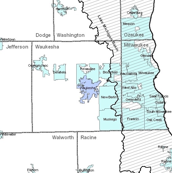
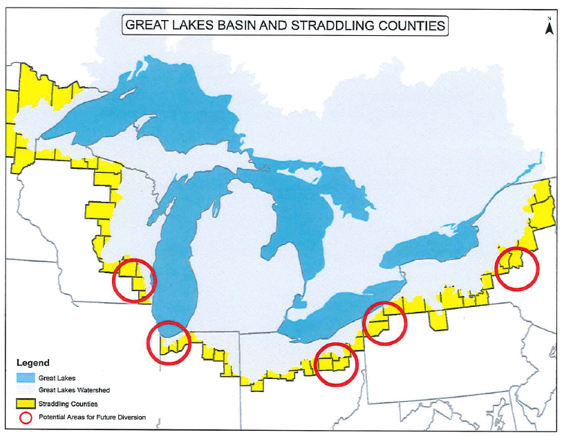
| 19:11, 21 May 2014 | Waukesha GL.jpg (file) |  |
95 KB | B Finney | This image was taken from: http://dnr.wi.gov/topic/wateruse/waukeshadiversionapp.html | 1 |
| 20:25, 23 May 2017 | Water Diplomacy Study Casevf.docx (file) | 159 KB | Jimena SG | 1 | ||
| 21:02, 30 April 2014 | Wat Arun.jpg (file) |  |
42 KB | TSP | Wat Arun, viewed from Chao Phraya River http://en.wikipedia.org/wiki/Chao_Phraya_River | 1 |
| 15:05, 16 July 2012 | Warning triangle.png (file) |  |
3 KB | Amanda | Created for AquaPedia. Released to Public Domain. CC-0. | 1 |
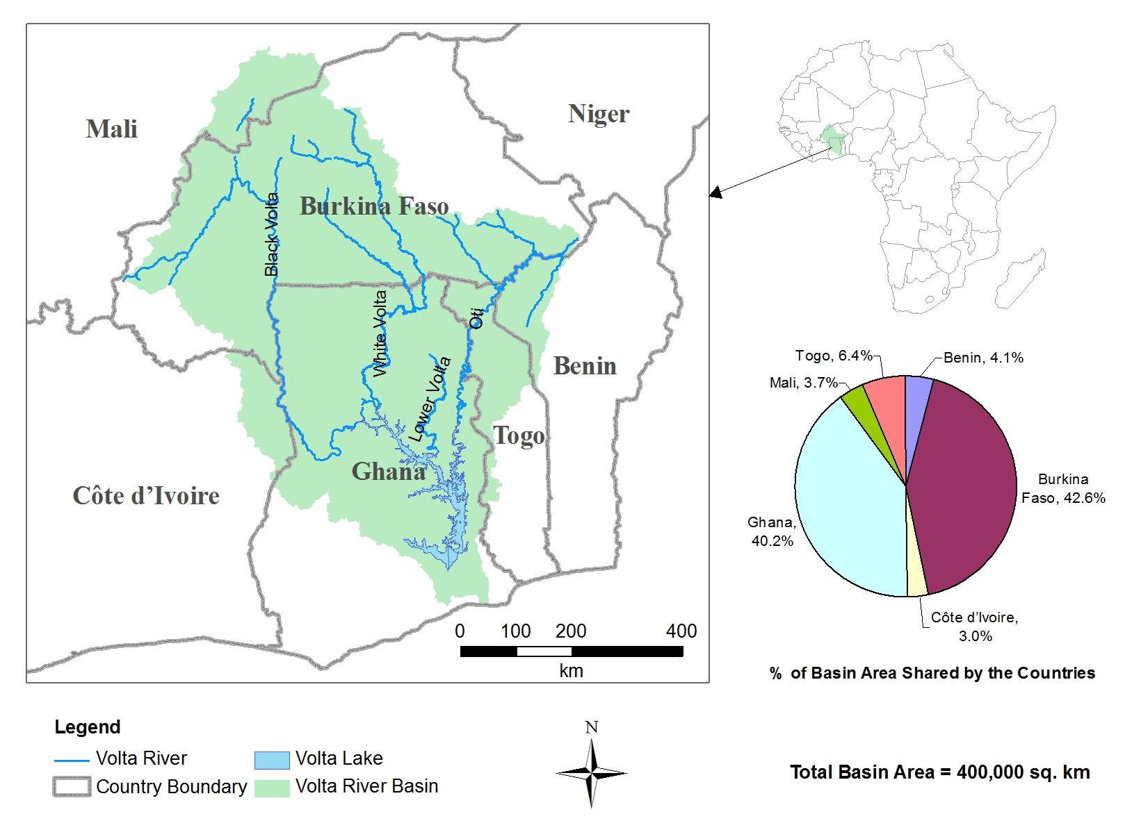
| 19:41, 23 March 2012 | Volta River Basin.jpg (file) |  |
161 KB | Administrator | 1 | |
| 16:41, 23 May 2017 | Visual Timeline of bilateral cooperation on the Yarlung Zangbo-Brahmaputra and the Zangmu Dam.jpg (file) |  |
38 KB | Cindynoe | 1 | |
| 10:20, 16 May 2013 | Visitor Growth in Los Vegas from 1970 to 2012.png (file) |  |
59 KB | Amanda | Produced 2013 by Margaret Garcia for Water Competition & Cooperation in the Las Vegas Valley Tourism continued to grow and Las Vegas saw a huge boom in tourism with annual visitors steadily increasing from 1970 until the mid-1990s. source: Las Vega | 1 |
| 22:38, 26 March 2012 | Variables.jpg (file) |  |
62 KB | Administrator | 1 | |
| 13:08, 28 January 2015 | Urmia9.JPG (file) |  |
19 KB | Zarghami | 2 | |
| 13:12, 28 January 2015 | Urmia8.jpg (file) |  |
29 KB | Zarghami | 1 | |
| 13:08, 28 January 2015 | Urmia8.JPG (file) |  |
29 KB | Zarghami | 2 | |
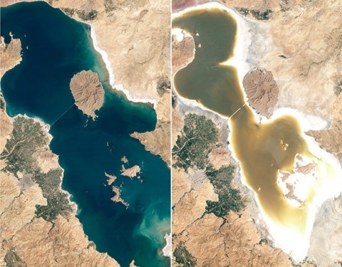
| 10:52, 28 January 2015 | Urmia7.jpg (file) |  |
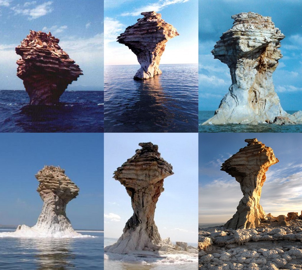
224 KB | Zarghami | The desiccation of Urmia Lake and its scenic impact (http://www.oxu.ca/lake/, accessed 12-06-2014) | 1 |
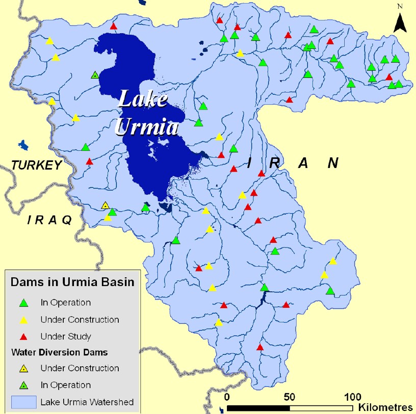
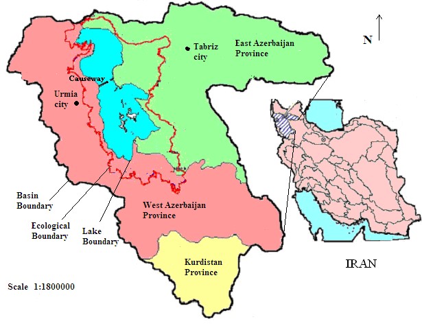
| 10:51, 28 January 2015 | Urmia6.jpg (file) |  |
159 KB | Zarghami | The locations of the dams in operation, construction and investigation (CIWP, 2014) | 1 |
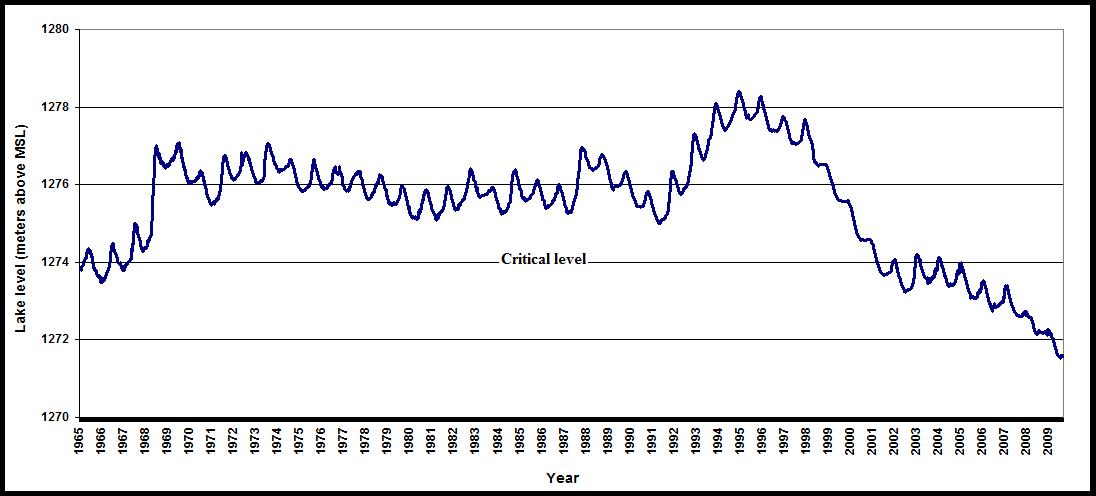
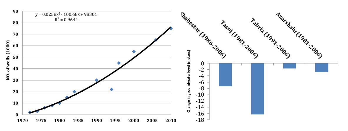
| 10:46, 28 January 2015 | Urmia5.jpg (file) |  |
63 KB | Zarghami | The annual stage of Urmia Lake (Zarghami 2010) | 1 |
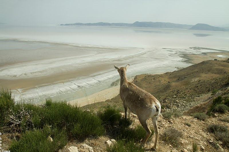
| 10:45, 28 January 2015 | Urmia4.jpg (file) |  |
119 KB | Zarghami | The mammals facing water shortages in the Islands within the Lake and may escape from their environment (Hobbi, 2014) | 1 |
| 10:44, 28 January 2015 | Urmia3.jpg (file) |  |
60 KB | Zarghami | Urmia Lake desiccation in recent 20 years | 1 |
| 10:42, 28 January 2015 | Urmia2.jpg (file) |  |
70 KB | Zarghami | 1 | |
| 13:55, 28 January 2015 | Urmia11.JPG (file) |  |
53 KB | Zarghami | 1 | |
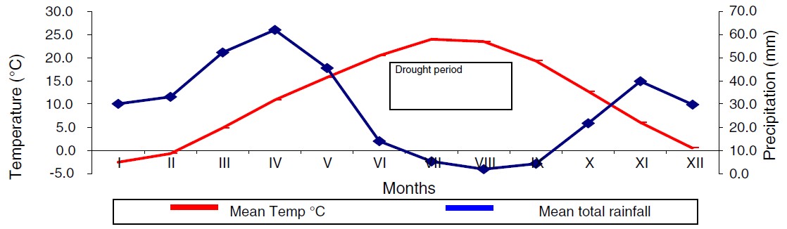
| 10:42, 28 January 2015 | Urmia1.jpg (file) |  |
62 KB | Zarghami | Ombrothermic diagram of Urmia station by using Emberger method, and precipitation and potential evapotranspiration, Urmia station (Delju et al 2013) | 1 |
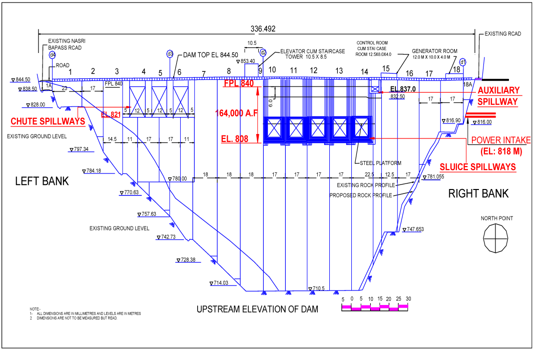
| 08:30, 30 January 2015 | Upstream-Elevation-of-Baglihar-Dam.png (file) |  |
45 KB | Ashfaqm | Schematic depicting upstream elevation of the Baglihar Dam. Original Source was cited as Pakistan Commission for Indus Waters, but it is published in Mahmoud, A. 2014. Hydro-diplomacy to Address the Transboundary Water Issues between India and Pakist... | 1 |
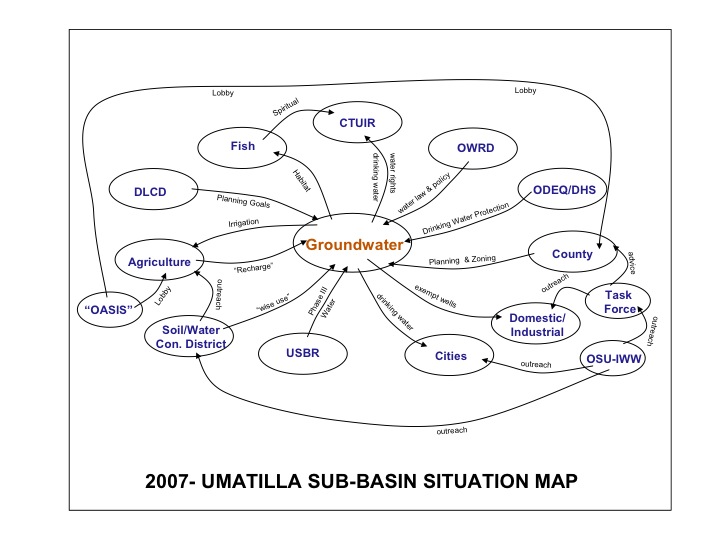
| 11:05, 23 August 2012 | Umatillanewmap.jpg (file) |  |
75 KB | Mpritchard | Created and provided by Dr. Todd Jarvis, Director of the Institute for Water and Watersheds, Oregon State University. The image is not copyrighted, though due credit is appreciated. Please attach the above credit when used. | 1 |
| 19:16, 21 May 2014 | US Straddling Counties.png (file) |  |
648 KB | B Finney | This image was taken from a presentation by the Waukesha Water Utility: http://www.ci.waukesha.wi.us/c/document_library/get_file?uuid=7480f775-3981-46a7-a7c0-c1f8579227b1&groupId=10113 | 1 |
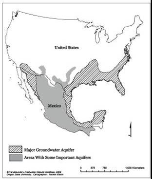
| 10:43, 21 August 2012 | US Mexico Aquifers.jpg (file) |  |
15 KB | Mpritchard | Wide use of electronic and hardcopy versions of data, GIS coverages, and findings produced by the Transboundary Freshwater Dispute Database (TFDD) project is encouraged. The data, coverages, and findings are not copyrighted, although due credit is apprec | 1 |
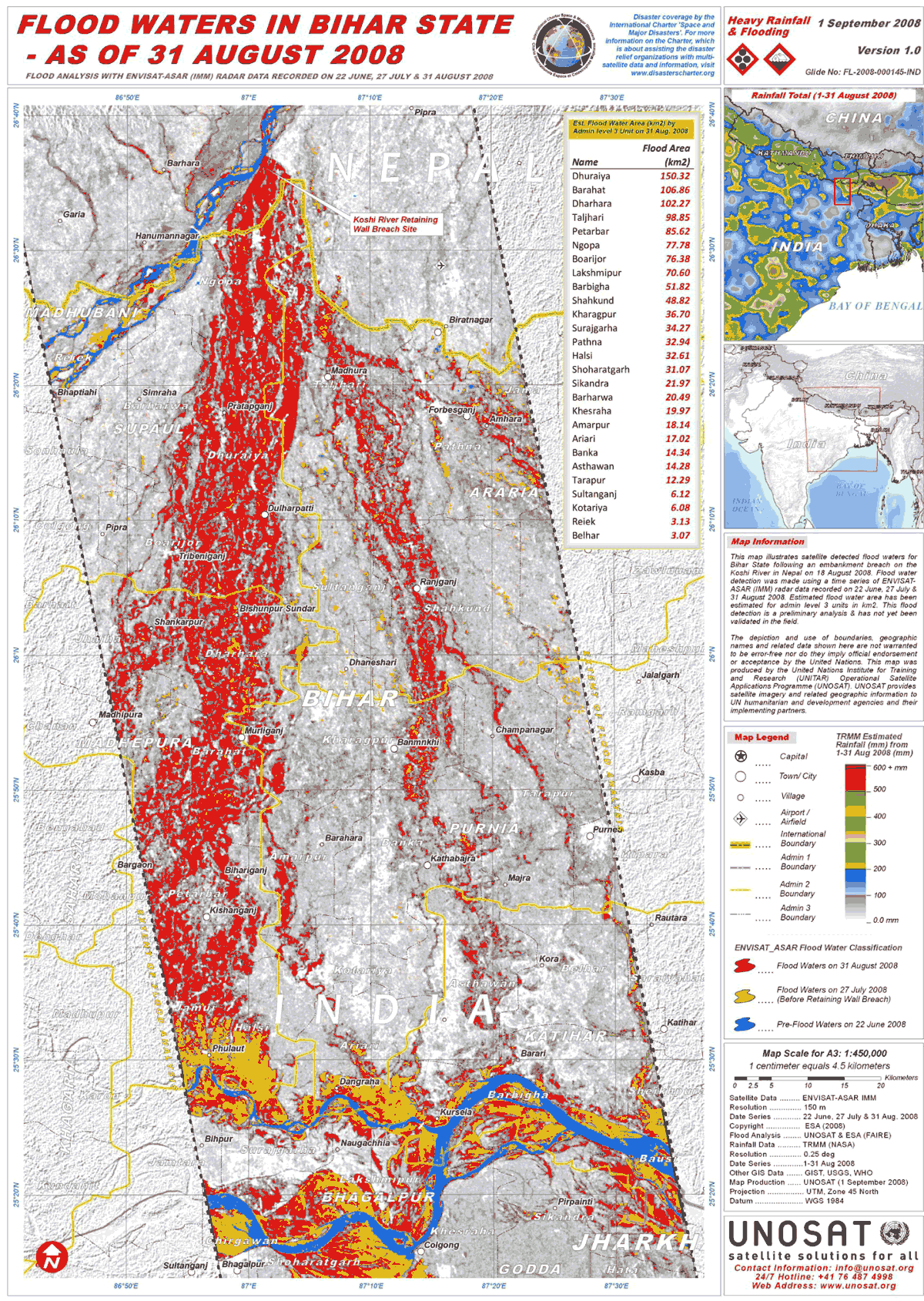
| 17:03, 25 June 2013 | UNOSAT IND Bihar Floods ASAR 31Aug08 Lowres.png (file) |  |
595 KB | Amanda | high-res .pdf available online: http://www.unitar.org/unosat/node/44/1259 Product ID: 1259 - English Published: 1 Sep, 2008 GLIDE: FL-2008-000145-IND “This map illustrates satellite detected flood waters for Bihar State following an embankment brea... | 1 |
| 14:09, 5 June 2017 | Timetable 2017-06-05 14.03.22.jpg (file) |  |
579 KB | Jimena SG | 1 | |
| 14:54, 5 June 2017 | Timetable22017-06-05 14.44.31.jpg (file) |  |
564 KB | Jimena SG | 1 | |
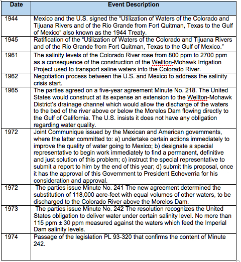
| 19:42, 23 March 2012 | Timeline.jpg (file) |  |
88 KB | Administrator | Timeline of Volta River Basin | 1 |
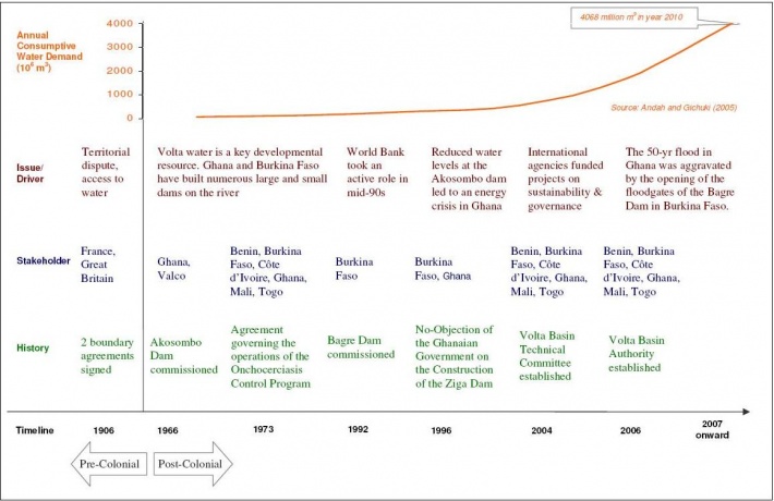
| 11:42, 14 August 2012 | Tigriseuphrates.jpg (file) |  |
30 KB | Mpritchard | Wide use of electronic and hardcopy versions of data, GIS coverages, and findings produced by the Transboundary Freshwater Dispute Database (TFDD) project is encouraged. The data, coverages, and findings are not copyrighted, although due credit is apprec | 1 |
| 10:14, 21 April 2012 | Test network.png (file) |  |
52 KB | Administrator | Gamma's network | 1 |
| 13:06, 26 May 2017 | Test.png (file) |  |
4 KB | Gtbrien | 1 | |
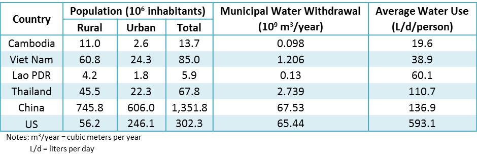
| 13:03, 20 May 2013 | Table 5 Water Consumption Comparison.jpg (file) |  |
51 KB | TAlarcon | Created by Tania Alarcon Data Source: Food and Agriculture Organization of the United Nations. (2013). AQUASTAT database. Retrieved from: www.fao.org/nr/water/aquastat/data/query/results.html | 1 |
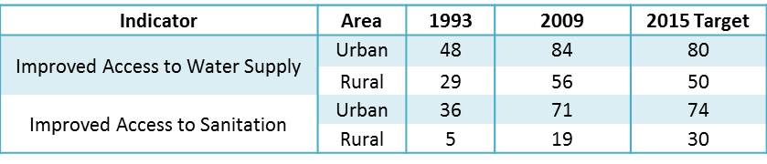
| 12:41, 20 May 2013 | Table 4 Cambodia Millenium Development Goals and Progress.jpg (file) | 23 KB | TAlarcon | Created by Tania Alarcon Data Source: Asian Development Bank. (2012). Cambodia: Water supply and sanitation sector assessment, strategy, and road map. Asian Development Bank, Mandaluyong City, Philippines. United Nations. (2013). Database - Millennium | 1 | |
| 12:32, 20 May 2013 | Table 3 PPWSA Water Quality (2012).jpg (file) | 50 KB | TAlarcon | Created by Tania Alarcon Data Source: Phnom Penh Water Supply Authority. (2013). History. Organization Structure. Production System. Distribution System. Water Quality. Non Revenue Water. Retrieved from: www.ppwsa.com.kh/en/index.php?page=history | 1 | |
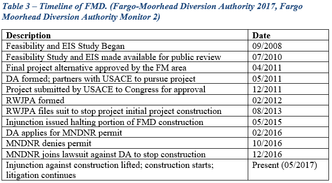
| 20:03, 6 June 2017 | Table 3.PNG (file) |  |
37 KB | Gtbrien | 3 | |
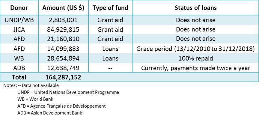
| 12:28, 20 May 2013 | Table 2 PPWSA Donors (1993 - 2009).jpg (file) | .jpg) |
59 KB | TAlarcon | Created by Tania Alarcon Data Source: Das, B., Chan, E. S., Visoth, C., Pangare, G., and Simpson, R., eds. (2010). Sharing the Reforms Process, Mekong Water Dialogue Publication No. 4, Gland, Switzerland: IUCN | 1 |
| 20:03, 6 June 2017 | Table 2.PNG (file) |  |
50 KB | Gtbrien | 4 | |
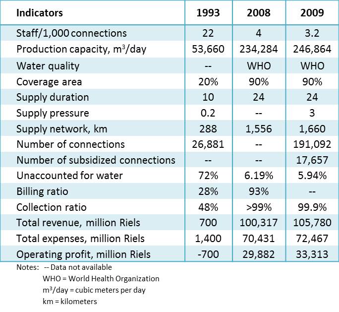
| 12:23, 20 May 2013 | Table 1 PPWSA Performance Indicators.jpg (file) |  |
76 KB | TAlarcon | 2 | |
| 19:51, 6 June 2017 | Table 1.PNG (file) |  |
15 KB | Gtbrien | 2 | |
| 19:47, 6 June 2017 | TEST.PNG (file) |  |
423 KB | Gtbrien | 1 | |
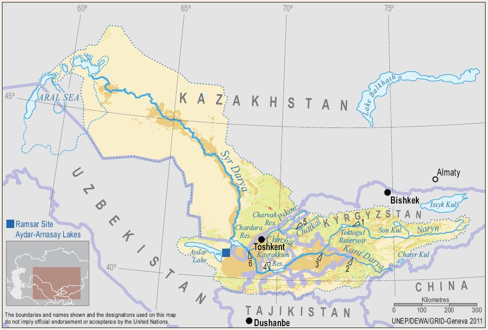
| 15:22, 22 January 2014 | Syr Darya.jpg (file) |  |
86 KB | Gsixt | The Syr Darya and its Major Tributaries | 1 |
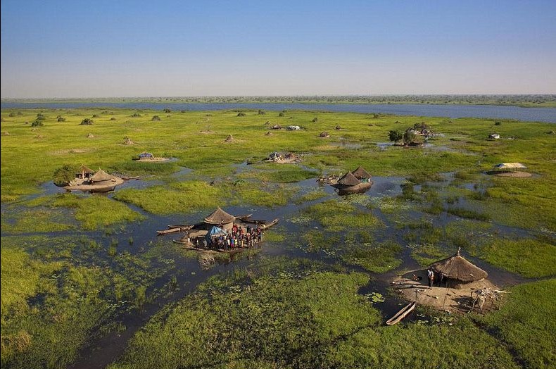
| 17:21, 21 December 2015 | Sudd.jpg (file) |  |
155 KB | Agustinbotteron | 1 | |
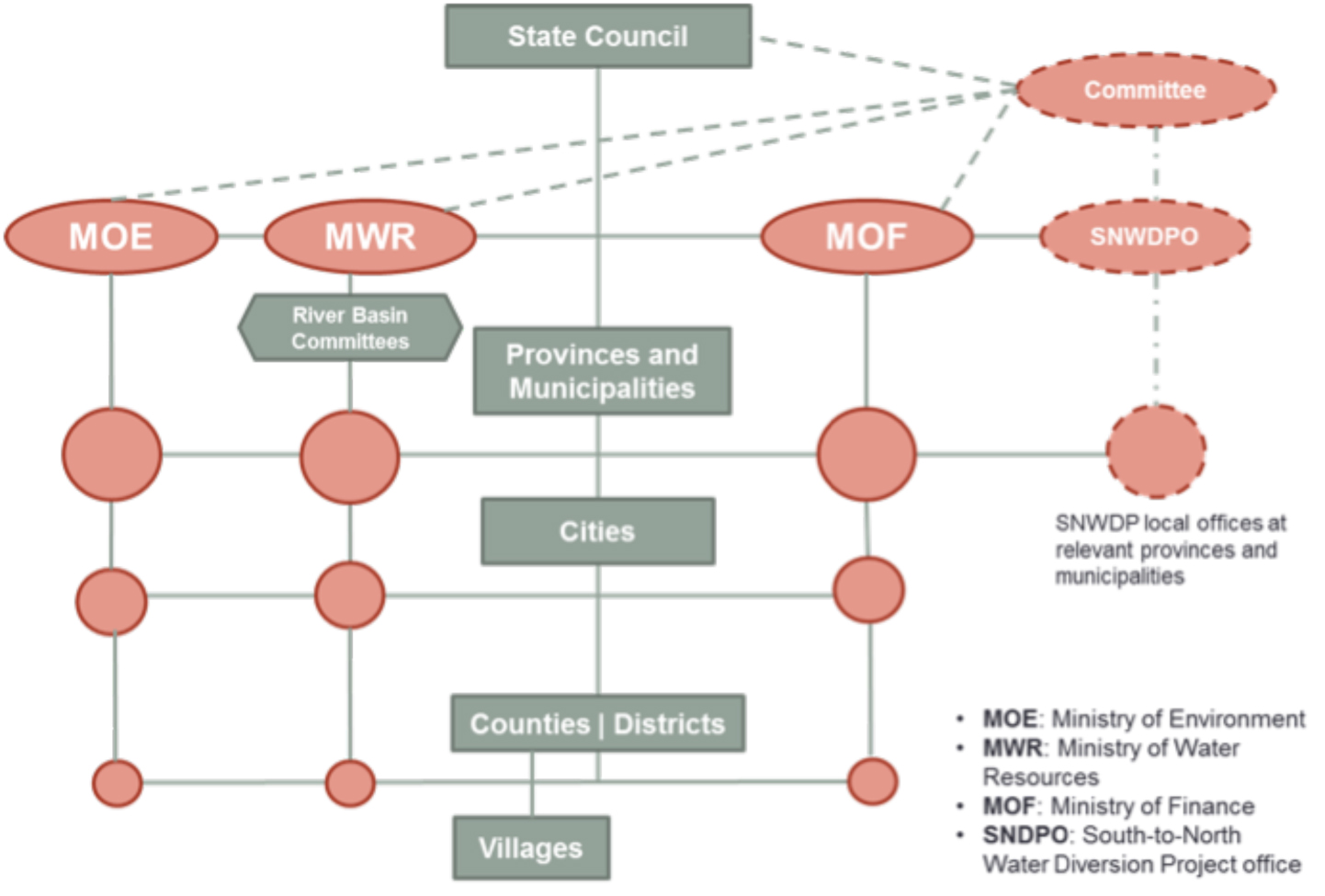
| 08:24, 6 June 2012 | Structure of china govt wang deangelis 2012.jpg (file) |  |
307 KB | Amanda | Political Structure of Chinese Government Developed for Middle Route Project Case Study Rose Wang and Kelly DeAngelis 2012. | 1 |
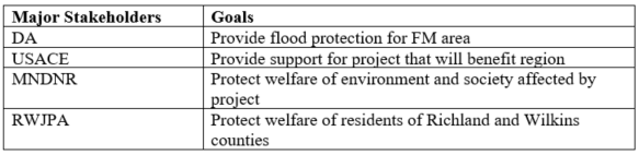
| 19:53, 5 June 2017 | Stakeholders1.PNG (file) | 27 KB | Gtbrien | 1 |
First page |
Previous page |
 Next page |
Last page |


.jpg)