File list
This special page shows all uploaded files.
| Date | Name | Thumbnail | User | Description | Versions | |
|---|---|---|---|---|---|---|
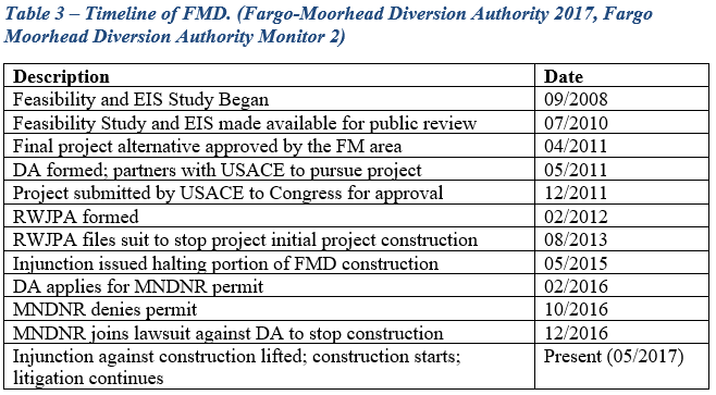
| 20:03, 6 June 2017 | Table 3.PNG (file) |  |
37 KB | Gtbrien | 3 | |
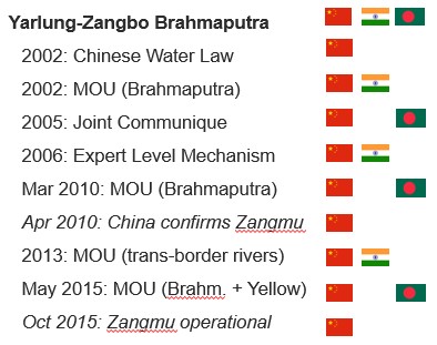
| 16:41, 23 May 2017 | Visual Timeline of bilateral cooperation on the Yarlung Zangbo-Brahmaputra and the Zangmu Dam.jpg (file) |  |
38 KB | Cindynoe | 1 | |
| 09:53, 9 January 2014 | Schematic of Govt Water Data Exchange Lebanon UNESCWA.png (file) |  |
39 KB | Amanda | Data Exchange between government water stakeholders in Lebanon (UNESCWA) This figure is from UNESCWA. WATER IN LEBANON STRATEGIC MANAGEMENT DATA NATIONAL ASSESSMENT MATRIX. 2012. Presentation PDF Online at https://unstats.un.org/unsd/envaccounting/wo... | 1 |
| 21:02, 30 April 2014 | Wat Arun.jpg (file) |  |
42 KB | TSP | Wat Arun, viewed from Chao Phraya River http://en.wikipedia.org/wiki/Chao_Phraya_River | 1 |
| 22:36, 26 March 2012 | Chronology.jpg (file) |  |
43 KB | Administrator | 1 | |
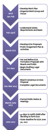
| 18:19, 31 October 2017 | Salinas GSA Process Roadmap.png (file) |  |
43 KB | SamKumasaka | Process Roadmap for SGMA Implementation/GSA Formation in Salinas Valley Groundwater Basin Created by Gina Bartlett (CBI, 2016) - https://www.svbgsa.com/process-timeline/ | 1 |
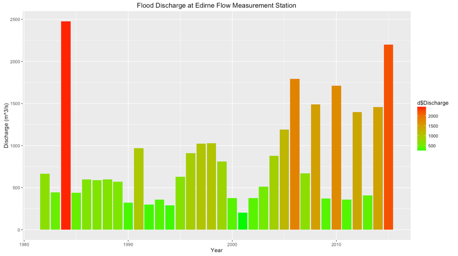
| 16:36, 29 May 2017 | MaritsaFlow.png (file) |  |
44 KB | OzgurB | 1 | |
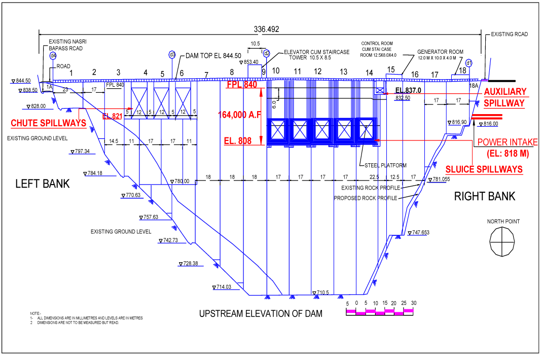
| 08:30, 30 January 2015 | Upstream-Elevation-of-Baglihar-Dam.png (file) |  |
45 KB | Ashfaqm | Schematic depicting upstream elevation of the Baglihar Dam. Original Source was cited as Pakistan Commission for Indus Waters, but it is published in Mahmoud, A. 2014. Hydro-diplomacy to Address the Transboundary Water Issues between India and Pakist... | 1 |
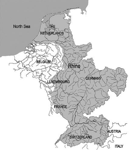
| 13:00, 15 May 2014 | Rhine River Basin.jpg (file) |  |
46 KB | Jcheung6 | 1 | |
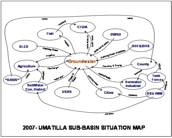
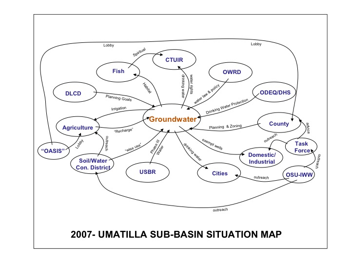
| 12:05, 27 July 2012 | 2007Umatillasubbasinsituationmap.jpg (file) |  |
46 KB | Mpritchard | Preliminary depiction of stakeholders and linkages for the groundwater situation in the Umatilla Basin, Northwestern US. “OASIS” was a proposed project to divert water from the Columbia River. DLCD denotes the Oregon Department of Land and Conservatio | 1 |
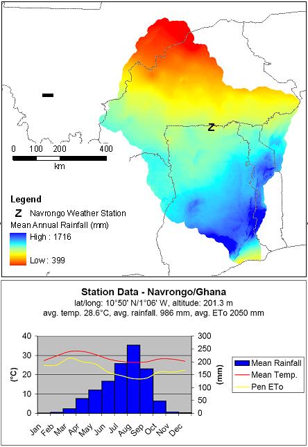
| 19:42, 23 March 2012 | Climatic Data.jpg (file) |  |
47 KB | Administrator | Climatic Data for Volta River Basin | 1 |
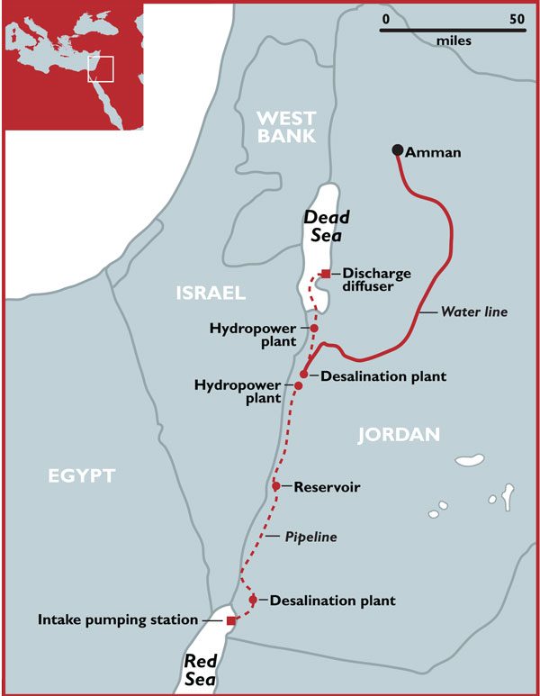
| 07:24, 25 May 2017 | Red-dead-sea.jpg.scale.LARGE.jpg (file) |  |
48 KB | Stolgay | The Red to Dead Sea Conveyance project includes a 180-kilometre pipeline engineered to carry up to two billion cubic metres of seawater per year from the Gulf of Aqaba on the Red Sea through Jordanian territory to the Red Sea as well as hydropower plan... | 1 |
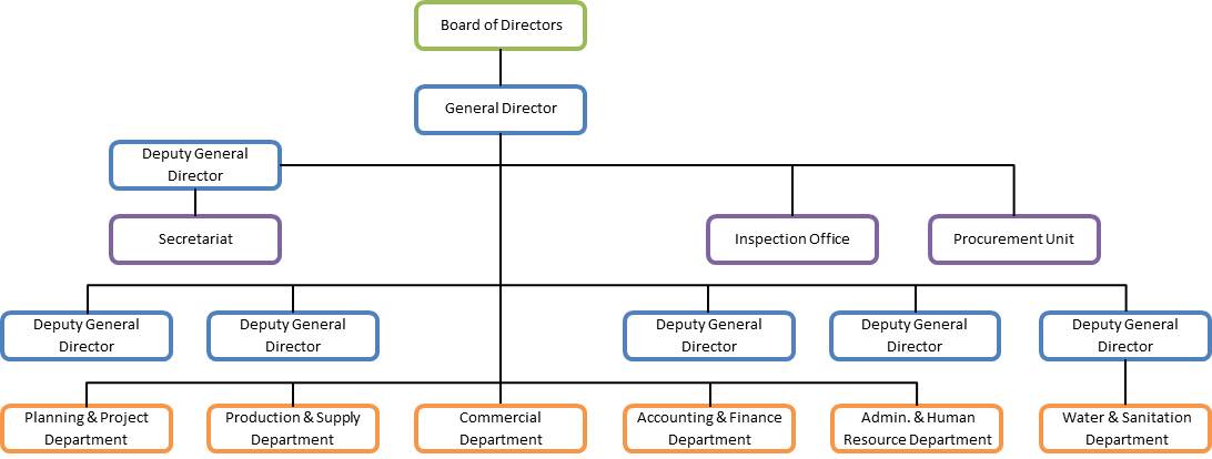
| 12:52, 20 May 2013 | PPWSA Governance.jpg (file) |  |
49 KB | TAlarcon | Created by Tania Alarcon Data Source: Phnom Penh Water Supply Authority. (2013). History. Organization Structure. Production System. Distribution System. Water Quality. Non Revenue Water. Retrieved from: www.ppwsa.com.kh/en/index.php?page=history | 1 |
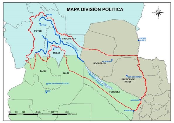
| 18:32, 25 May 2017 | Map PilcomayoBasin.jpg (file) |  |
49 KB | Julian Kölbel | This map delineates the Pilcomayo River Basin and shows how it is shared between the riparian states Bolivia, Paraguay, and Argentina. It also shows how the Pilcomayo forms extensive wetlands at the border between Paraguay and Argentina, called the Ban... | 2 |
| 12:32, 20 May 2013 | Table 3 PPWSA Water Quality (2012).jpg (file) | 50 KB | TAlarcon | Created by Tania Alarcon Data Source: Phnom Penh Water Supply Authority. (2013). History. Organization Structure. Production System. Distribution System. Water Quality. Non Revenue Water. Retrieved from: www.ppwsa.com.kh/en/index.php?page=history | 1 | |
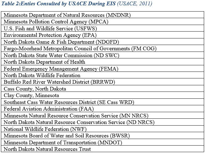
| 20:03, 6 June 2017 | Table 2.PNG (file) |  |
50 KB | Gtbrien | 4 | |
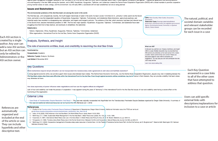
| 15:31, 7 January 2013 | AquaPedia-Screenshot-case1.png (file) |  |
50 KB | Amanda | Screenshot with notation showing some of the parts of a case study. | 1 |
| 14:51, 17 May 2013 | Cambodia map.jpg (file) |  |
51 KB | TAlarcon | Graphic Produced by Tania Alarcon Adapted from Wikipedia | 1 |
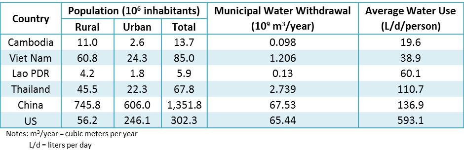
| 13:03, 20 May 2013 | Table 5 Water Consumption Comparison.jpg (file) |  |
51 KB | TAlarcon | Created by Tania Alarcon Data Source: Food and Agriculture Organization of the United Nations. (2013). AQUASTAT database. Retrieved from: www.fao.org/nr/water/aquastat/data/query/results.html | 1 |
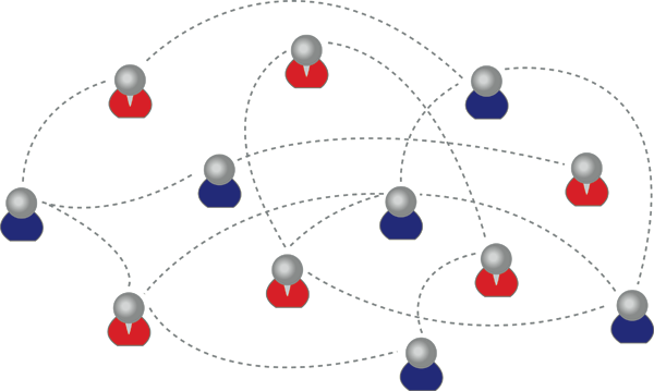
| 10:14, 21 April 2012 | Test network.png (file) |  |
52 KB | Administrator | Gamma's network | 1 |
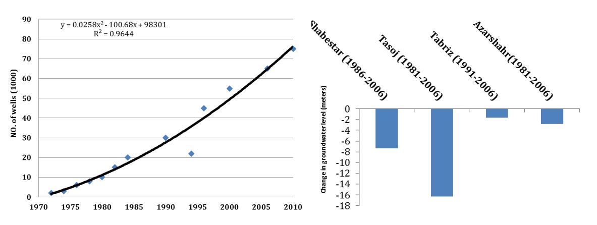
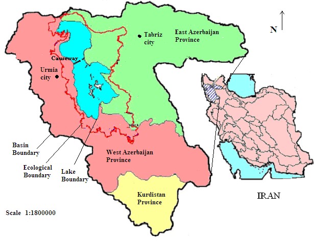
| 13:55, 28 January 2015 | Urmia11.JPG (file) |  |
53 KB | Zarghami | 1 | |
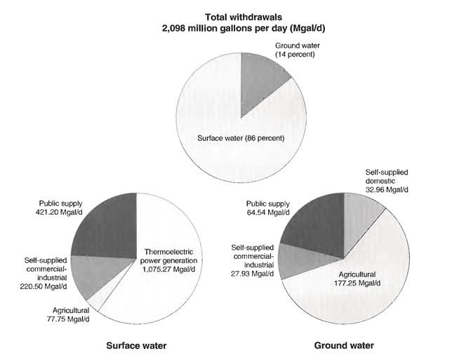
| 16:30, 28 February 2013 | ACF-total-withdrawal-pie-chart.png (file) |  |
55 KB | Amanda | This is figure 29. Ground- and surface-water withdrawals by principal water use-categories in the Apalachicola-Chattahoochee-Flint River basin, 1990 (data from Marella andothers, 1993) which appeared in Influences of environmental settings on aquatic ecos | 1 |
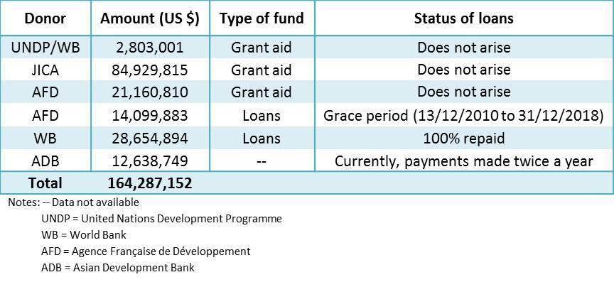
| 12:28, 20 May 2013 | Table 2 PPWSA Donors (1993 - 2009).jpg (file) | .jpg) |
59 KB | TAlarcon | Created by Tania Alarcon Data Source: Das, B., Chan, E. S., Visoth, C., Pangare, G., and Simpson, R., eds. (2010). Sharing the Reforms Process, Mekong Water Dialogue Publication No. 4, Gland, Switzerland: IUCN | 1 |
| 10:20, 16 May 2013 | Visitor Growth in Los Vegas from 1970 to 2012.png (file) |  |
59 KB | Amanda | Produced 2013 by Margaret Garcia for Water Competition & Cooperation in the Las Vegas Valley Tourism continued to grow and Las Vegas saw a huge boom in tourism with annual visitors steadily increasing from 1970 until the mid-1990s. source: Las Vega | 1 |
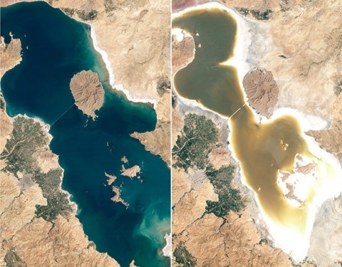
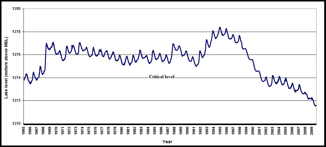
| 10:44, 28 January 2015 | Urmia3.jpg (file) |  |
60 KB | Zarghami | Urmia Lake desiccation in recent 20 years | 1 |
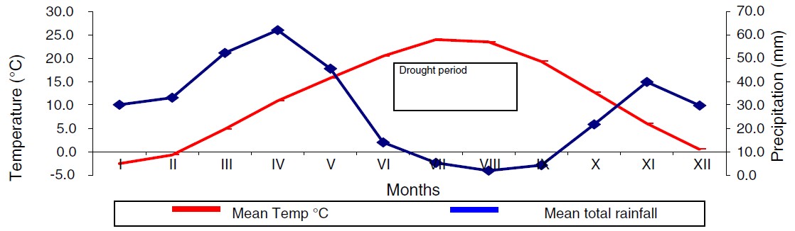
| 10:40, 28 January 2015 | 1.jpg (file) |  |
62 KB | Zarghami | Ombrothermic diagram of Urmia station by using Emberger method, and precipitation and potential evapotranspiration, Urmia station (Delju et al 2013) | 1 |
| 10:42, 28 January 2015 | Urmia1.jpg (file) |  |
62 KB | Zarghami | Ombrothermic diagram of Urmia station by using Emberger method, and precipitation and potential evapotranspiration, Urmia station (Delju et al 2013) | 1 |
| 22:38, 26 March 2012 | Variables.jpg (file) |  |
62 KB | Administrator | 1 | |
| 10:46, 28 January 2015 | Urmia5.jpg (file) |  |
63 KB | Zarghami | The annual stage of Urmia Lake (Zarghami 2010) | 1 |
| 22:36, 26 March 2012 | British Administration.jpg (file) |  |
65 KB | Administrator | 1 | |
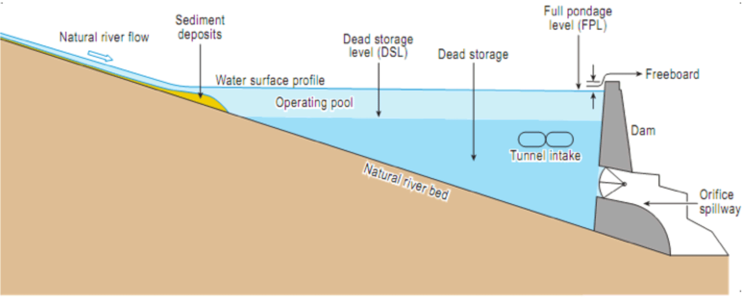
| 11:11, 29 January 2015 | Schematic side view typical dam.png (file) |  |
67 KB | Ashfaqm | A generic schematic showing the side view of a typical dam with low-level outlets. This graphic is from the Court of Arbitration (CoA) 2013a. Partial Award Indus Waters Kishenganga Arbitration (Pakistan v. India) (18 February). Documents linked for do... | 1 |
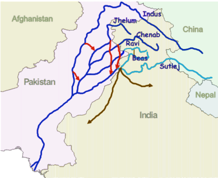
| 09:10, 30 January 2015 | Indus-River-Linking-Project-Pakistan.png (file) |  |
67 KB | Ashfaqm | From World Bank (2005) Pakistan Country Water Resources Assistance Strategy Water Economy: Running Dry. Report No. 34081-PK. Washington, DC: World Bank. Available Online http://documents.worldbank.org/curated/en/2005/11/6492396/pakistan-country-water... | 1 |
| 22:36, 26 March 2012 | During Partition.jpg (file) |  |
68 KB | Administrator | 1 | |
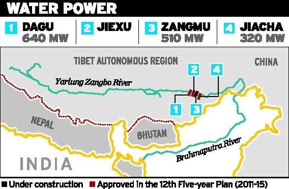
| 16:41, 23 May 2017 | Zangmu Dam and other planned Chinese dams on the Yarlung Zangbo-Brahmaputra.jpg (file) |  |
68 KB | Cindynoe | 1 | |
| 10:42, 28 January 2015 | Urmia2.jpg (file) |  |
70 KB | Zarghami | 1 | |
| 22:37, 26 March 2012 | Indus Waters Treaty.jpg (file) |  |
70 KB | Administrator | 1 | |
| 12:46, 20 May 2013 | Cambodia Governance.jpg (file) |  |
72 KB | TAlarcon | Created by Tania Alarcon Data Source: Phnom Penh Water Supply Authority. (2013). History. Organization Structure. Production System. Distribution System. Water Quality. Non Revenue Water. Retrieved from: www.ppwsa.com.kh/en/index.php?page=history Wate | 1 |
| 11:05, 23 August 2012 | Umatillanewmap.jpg (file) |  |
75 KB | Mpritchard | Created and provided by Dr. Todd Jarvis, Director of the Institute for Water and Watersheds, Oregon State University. The image is not copyrighted, though due credit is appreciated. Please attach the above credit when used. | 1 |
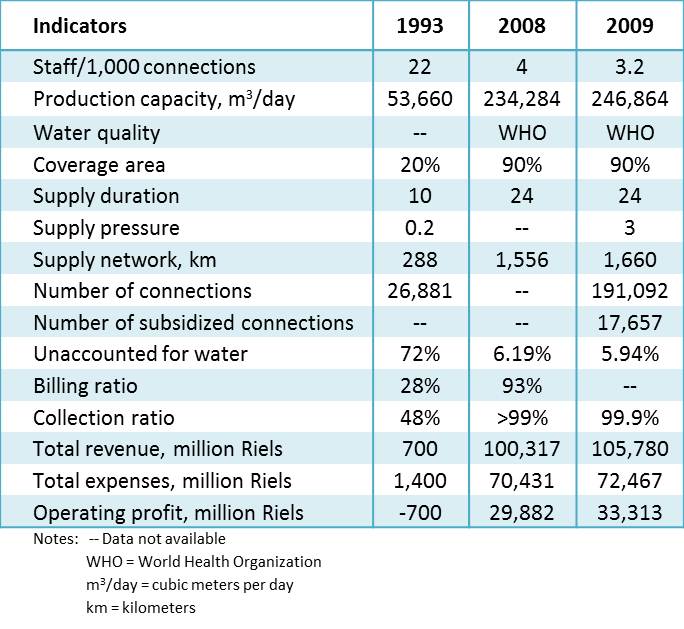
| 12:23, 20 May 2013 | Table 1 PPWSA Performance Indicators.jpg (file) |  |
76 KB | TAlarcon | 2 | |
| 16:07, 7 January 2013 | AquaPedia-Screenshot-case2.png (file) |  |
78 KB | Amanda | CC by SA 3.0 Screenshot showing case study sections. | 1 |
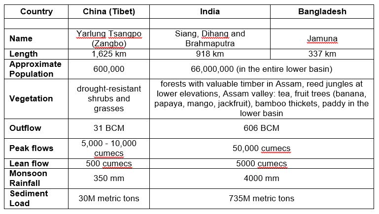
| 16:16, 23 May 2017 | Yarlung Zangbo Brahmaputra key basin statistics country by country.jpg (file) |  |
84 KB | Cindynoe | 1 | |
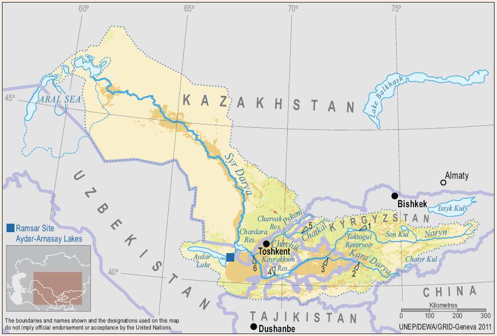
| 15:22, 22 January 2014 | Syr Darya.jpg (file) |  |
86 KB | Gsixt | The Syr Darya and its Major Tributaries | 1 |
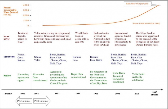
| 19:42, 23 March 2012 | Timeline.jpg (file) |  |
88 KB | Administrator | Timeline of Volta River Basin | 1 |
| 16:07, 25 January 2013 | AP-screenshot-WMC.png (file) |  |
92 KB | Amanda | Screenshot showing how to incorporate a file from Wikimedia Commons into an AquaPedia Case | 1 |
| 19:11, 21 May 2014 | Waukesha GL.jpg (file) |  |
95 KB | B Finney | This image was taken from: http://dnr.wi.gov/topic/wateruse/waukeshadiversionapp.html | 1 |
| 19:20, 21 May 2014 | Root River Pipeline.jpg (file) |  |
101 KB | B Finney | This image was taken from: http://www.jsonline.com/news/waukesha/waukesha-buys-option-on-land-for-root-river-discharge-ce8jmke-189591171.html | 1 |
| 16:40, 23 May 2017 | Fig 4. Water Resources - Availability and Utilization in India.jpg (file) |  |
101 KB | Cindynoe | 1 | |
| 09:57, 29 July 2014 | Site-main-slide02.png (file) | 103 KB | Amanda | This is a descriptive slide used on the main page. | 1 | |
| 13:54, 1 August 2014 | Site-main-slide03-01.png (file) | 115 KB | Amanda | A slide for the main paige to promote the AquaPedia RFP | 1 | |
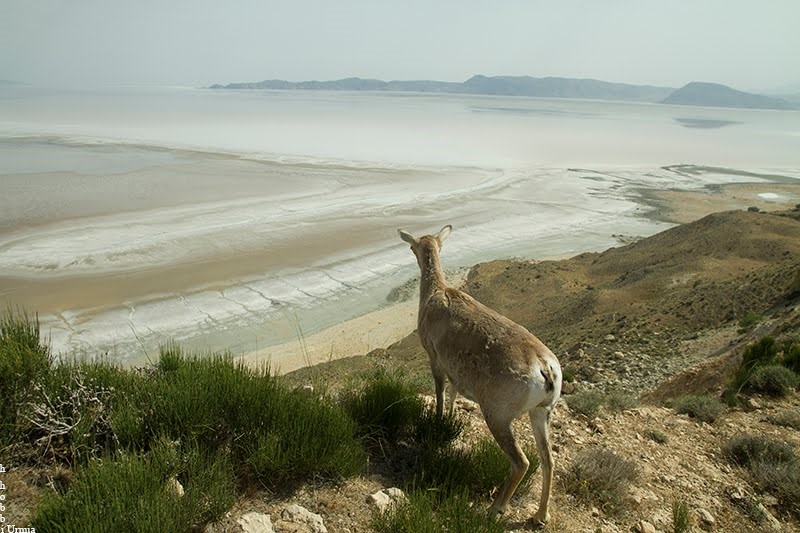
| 10:45, 28 January 2015 | Urmia4.jpg (file) |  |
119 KB | Zarghami | The mammals facing water shortages in the Islands within the Lake and may escape from their environment (Hobbi, 2014) | 1 |
First page |
Previous page |
Next page |
Last page |


.jpg)