Integrated Management and Negotiations for Equitable Allocation of Flow of the Jordan River Among Riparian States
| Geolocation: | 32° 9' 25.245", 35° 33' 6.3281" |
|---|---|
| Total Population | 1212,000,000 millionmillion |
| Total Area | 4280042,800 km² 16,525.08 mi² km2 |
| Climate Descriptors | Arid/desert (Köppen B-type), Continental (Köppen D-type), Dry-winter |
| Predominent Land Use Descriptors | agricultural- cropland and pasture, industrial use, urban- high density, religious/cultural sites |
| Important Uses of Water | Agriculture or Irrigation, Domestic/Urban Supply, Hydropower Generation |
Contents
Summary
The Jordan River flows between five particularly contentious riparians, two of which rely on the river as the primary water supply. By the early-1950s, there was little room for any unilateral development without impacting on other riparian states. The initial issue was an equitable allocation of the annual flow of the Jordan watershed between its riparian states- Israel, Jordan, Lebanon, and Syria. Egypt also was included, given its preeminence in the Arab world. Until the current Arab-Israeli peace negotiations, which began in 1991, political or resource problems were always handled separately. The initiatives which were addressed as strictly water resource issues, namely-the Johnston Negotiations of the mid-1950s, attempts at "water-for-peace" through nuclear desalination in the late 1960s, negotiations over the Yarmuk River in the 1970s and 1980s, and the Global Water Summit Initiative of 1991, all failed to one degree or another, because they were handled separately from overall political discussions. The resolution of water resources issues then had to await the Arab-Israeli peace talks to meet with any tangible progress. The pace of success of each round of talks has vacillated but, in general, has been increasing. The goal in the Working Group on Water Resources became to plan for a future region at peace, and to leave the pace of implementation to the bilateral talks. This distinction between "planning" and "implementation" became crucial, with progress only being made as the boundary between the two is continuously pushed and blurred by the mediators. Multilateral activities have helped set the stage for agreements formalized in bilateral negotiations-the Israel-Jordan Treaty of Peace of 1994, and the Interim Agreements between Israel and the Palestinians (1993 and 1995). For the first time since the states came into being, the Israel-Jordan peace treaty legally spells out mutually recognized water allocations. The Interim Agreement also recognizes the water rights of both Israelis and Palestinians, but defers their quantification until the final round of negotiations.
Natural, Historic, Economic, Regional, and Political Framework
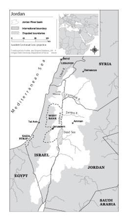
 Figure 1. Map of the Jordan River and tributaries (directly and indirectly, including Litani) [1]
Analysis, Synthesis, and Insight
Individuals may add their own Analysis, Synthesis, and Insight (ASI) to a case. ASI sub-articles are protected, so that each contributor retains authorship and control of their own content. Edit the case to add your own ASI.
Learn moreASI:Jordan River: Lessons learned and creative outcomes
Contributed by: Aaron T. Wolf, Joshua T. Newton, Matthew Pritchard (last edit: 12 February 2013)
- ^ Transboundary Freshwater Dispute Database (TFDD) (2007). Oregon State University. Available on-line at: http://www.transboundarywaters.orst.edu


