File:Coastal-Aquifer-Extent.png
Summary
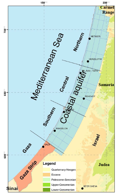
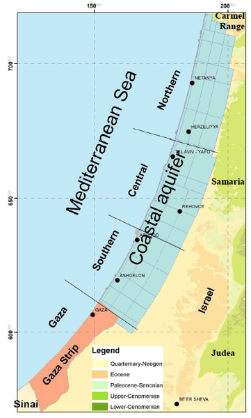
low-res Image showing the extent of the Coastal Aquifer.
This image is figure 17 in : Weinberger, G. et al. 2012. The Natural Water Resources between the Meditteranean Sea and the Jordan River. Israel Hydrologic Service. Jerusalem. online: http://www.water.gov.il/Hebrew/ProfessionalInfoAndData/Data-Hidrologeime/DocLib4/water_report-MEDITERRANEAN-SEA-AND-THE-JORDAN.pdf
Licensing
Files listed as having license "other" do not conform to a standard public domain or creative commons standard.
This may be a file that has been included with the express permission of the creator/owner, or it may be included under the fair-use exclusion. AquaPedia will remove any files which are obviously presented in violation of their copyright, or at the request of the content owner.
Please see the file summary for more info. If you added this file, please annotate the file summary with information about the file and its terms of use and reason it was included.
File history
Click on a date/time to view the file as it appeared at that time.
| Date/Time | Thumbnail | Dimensions | User | Comment | |
|---|---|---|---|---|---|
| current | 09:20, 26 June 2014 | | 405 × 673 (210 KB) | Amanda (Talk | contribs) | low-res Image showing the extent of the Coastal Aquifer. This image is figure 17 in : Weinberger, G. et al. 2012. The Natural Water Resources between the Meditteranean Sea and the Jordan River. Israel Hydrologic Service. Jerusalem. online: http://www.... |
- You cannot overwrite this file.
File usage
The following 2 pages link to this file:


