File:2007Umatillasubbasinsituationmap.jpg
Summary
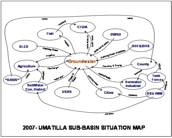
Preliminary depiction of stakeholders and linkages for the groundwater situation in the Umatilla Basin, Northwestern US. “OASIS” was a proposed project to divert water from the Columbia River. DLCD denotes the Oregon Department of Land and Conservation and Development. USBR is the US Bureau of Reclamation. OWRD is the Oregon Water Resources Department. CTUIR is the Confederated Tribes of the Umatilla Indian Reservation. ODEQ/DHS are the Oregon Department of Environmental Quality and the Department of Human Services. OSU-IWW is the Oregon State University, Institute for Water and Watersheds (Jarvis, 2010).
Licensing
Creative Commons Attribution-Share Alike
View a CC-by-SA on the Creative Commons website for more information about this type of content licensing.
Additionally, there is easy to read information about this topic at Wikipedia (Article: Creative Commons license).
See file description for additional details on the type and scope of agreement for the specific file referenced.
File history
Click on a date/time to view the file as it appeared at that time.
| Date/Time | Thumbnail | Dimensions | User | Comment | |
|---|---|---|---|---|---|
| current | 12:05, 27 July 2012 | | 580 × 465 (46 KB) | Mpritchard (Talk | contribs) | Preliminary depiction of stakeholders and linkages for the groundwater situation in the Umatilla Basin, Northwestern US. “OASIS” was a proposed project to divert water from the Columbia River. DLCD denotes the Oregon Department of Land and Conservatio |
- You cannot overwrite this file.
File usage
There are no pages that link to this file.


