Apalachicola-Chattahoochee-Flint River Basin
Apalachicola-Chattahoochee-Flint River Basin Facts
Basin Area: 51281 51,281 km²
19,794.466 mi² km2
Type:watershed or basin
Includes Riparians: Georgia (U.S.); Alabama; Florida;
Facts about included riparians are at the end of the article. Fact References[1]
[2]
The ACF basin lies in Georgia, Alabama, and Florida and contains three smaller basins (the Apalachicola River, the Chattahoochee River & Flint River basins) and five major aquifer systems.
Water management in the ACF has long been a highly contentious issue. Conflict over water in the ACF is largely driven by three competing demands: water for urban and industrial uses (water quantity, assets, and governance) in upstream Atlanta, agricultural water needs (water quantity and assets) in southern Georgia, and water for ecological and fisheries needs (ecosystems, water quantity, water quality) in Florida’s Apalachicola Bay.
Contents
Geography
The ACF basin lies in Georgia, Alabama, and Florida and contains three smaller basins (the Apalachicola River, the Chattahoochee River & Flint River basins) and five major aquifer systems. [3]
The Chattahoochee and Flint Rivers flow south to converge at Lake Seminole, and from there the Apalachicola River flows to Apalachicola Bay.
ACF Basin, courtesy Wikimedia Commons
Water Use
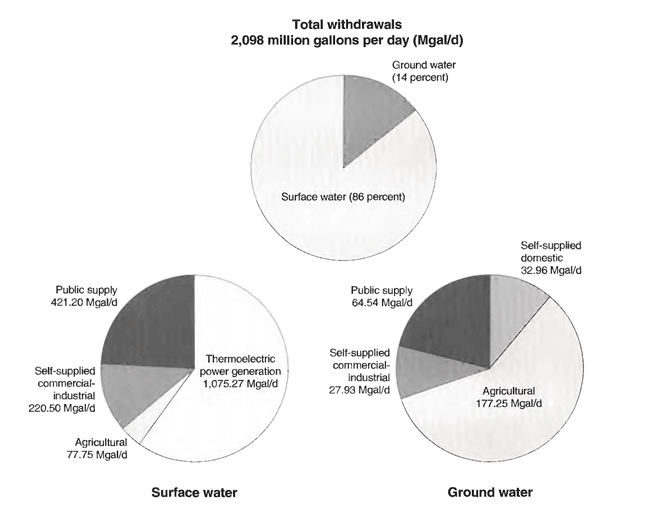
Surface water (86% of basin usage) is used mostly for power generation, public water supply (including domestic, industrial, and commercial use), self-supplied for commercial or industrial use, and agricultural use.[3]
Groundwater (14% of basin usage) is primarily used for irrigated agriculture, and then public supply. A smaller portion of groundwater is used for self-supplied domestic or commericial-industrial use. [3]

Case Studies linked to Apalachicola-Chattahoochee-Flint River Basin[edit]
Articles linked to Apalachicola-Chattahoochee-Flint River Basin[edit]
| Riparians | Water Features |
|---|---|
|
Located in this basin- Florida
|
|
| Projects and Initiatives | Agreements and Treaties |
|---|---|
|
|
|
External Links
- ACF Data Portal at the National Integrated Drought Information System — The National Integrated Drought Information System (NIDIS) website connects to the U.S. Drought Portal with drought related maps and data products for U.S. water resources.
- USACE Mobile District Water Management Section — Current and historical inflow/outflow data, and lake level forecasts for Lanier, Westpoint, George, Woodruff, Blountstown, and Buford.
Facts about Included Riparians
| Riparian | Population in Basin | Area within Basin in sq. km | Irrigated Lands within Basin in sq km | Average Discharge in cubic m per second |
|---|---|---|---|---|
| Florida | ||||
| Georgia (U.S.) | ||||
| Alabama |
- ^ Richter, Brian D., Mathews, R H, Harrison, D. L. and Wigington, R. (February 2003) Ecologically Sustainable Water Management: Managing River Flows For Ecological Integrity Ecological Applications volume 13 issue 1 pages 206–224. Available online: http://web.archive.org/web/20061214110920/http://www.nature.org/summit/files/eswm.pdf last accessed: Feb 28 2013
- ^ USGS. The Apalachicola-Chattahoochee-Flint (ACF) River National Water Quality Assessment (NAWQA) Program study Available online: http://ga.water.usgs.gov/nawqa/publications/environ.html
- ^ 3.0 3.1 3.2 3.3 Couch, C. A.; Hopkins, E. H.; and Hardy, P. S. (1996) Influences of environmental settings on aquatic ecosystems in the Apalachicola-Chattahoochee-Flint River basin USGS Water-Resources Investigations Report: 95-4278. (available online:http://pubs.usgs.gov/wri/1995/4278/report.pdf)
| Basin Area | 51,281 km² (19,794.466 mi²) + |
| Riparian | Georgia (U.S.) +, Alabama + and Florida + |
| Water Feature Type | Watershed or basin + |
| Has subobjectThis property is a special property in this wiki. | Apalachicola-Chattahoochee-Flint River Basin +, Apalachicola-Chattahoochee-Flint River Basin + and Apalachicola-Chattahoochee-Flint River Basin + |
 This is the


