Coastal Aquifer (Israel, Palestine)
Coastal Aquifer (Israel, Palestine) Facts
Recharge Rate:232000000232,000,000 cm/year cm/year
Type:aquifer
Contents
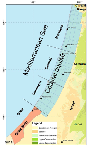
The Coastal Aquifer's northern bounds is in the Carmel range and it extends to the Sinai Peninsula. Only the southern most portion of the aquifer extends to Gaza. [1]The supply of fresh water to the population of Gaza is almost totally reliant on the Coastal Aquifer.

The Coastal Aquifer in Gaza
The southernmost portion of the coastal aquifer is the primary source for natural freshwater in Gaza. The shallow sandy aquifer, extending eastward to Israel and southward to Egypt. There are more than 5,000 water wells, most of them for agriculture purposes and with an average depth of 40-70 meters, and the water table lies between 20-50 meters below the ground surface.[2] Gaza is a dry area and local aquifer recharge is very limited (55-60 MCM/year on average). Abstraction by all users (Israelis, Egyptians and Palestinians) already far exceeds natural recharge.[3] Consequently, the aquifer has been depleted and suffers from seawater intrusion. Groundwater abstraction in Gaza has reached 180 MCM/ year, whereas the natural aquifer recharge on this portion of the aquifer is estimated to be only 55 MCM/ year.[4] Abstraction rates have increased markedly over the last three decades, due to a combination of inadequate available water imports to Gaza; the expanding population; and the drilling and use of unlicensed wells (especially to provide irrigation for agricultural activities)[5]. For this reason, the long-term strategy aims to reduce total groundwater abstraction in Gaza from the current rate of 180 MCM/ year to 70 MCM/ year in 2032.[2]
Restoring the Aquifer
The costal aquifer is depleted as a result of disequilibrium between the total water abstraction and its renewable amount, where the water level has been declining during the last few years to about 10-15 m below sea level.[2] One of the stakeholders working in Gaza put it as follows: “Gazans know that they are destroying the aquifer but they do not have any other options hence they are looking at desalination plants to minimize the abstractions from the aquifer.” Apart from the fact that the Gaza Coastal Aquifer receives insufficient rainwater quantities for recharge, Israeli water policies have aimed at further reducing the aquifer’s renewable yield through the impediment of surface and groundwater[6] On one hand, Israel diverted around 20 MCM/ year of surface water from Wadi Ghaza to agricultural fields in Israel before its arrival in Gaza (westwards)[6]. On the other hand, the natural groundwater flow from Israel to the Coastal Aquifer (eastwards) has been reduced through the drilling of a number of deep wells along the Israel-Gaza border.[6] The degree to which such flows might have contributed historically to the recharge of the Gaza groundwater system may be contemplated.[5] It is noted that even if Wadi Gaza were to flow on downstream into Gaza in the future, only limited quantities of such flows could be captured and utilized, and these would be available during the wet season, when the demand is lower in any event.[5]
Seawater Intrusion
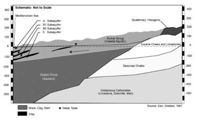
Groundwater depletion in the Coastal aquifer has two negative impacts: (a) seawater invasion of large parts of the inland aquifer and (b) upward leakage of the underneath saline water. As a result of that depletion, the groundwater salinity has been increasing significantly to an unacceptable level, where 95% of the pumped water exceeds World Health Organization (WHO) drinking limit (250 mg/l) in terms of chloride concentration. While around 70% of the urban area is served by wastewater collection system, many people are still using cesspits or septic tanks for dumping their raw wastewater. Hence a huge amount of untreated wastewater leaks through the unsaturated sandy zone each day causing the groundwater pollution. As recorded, groundwater pollution by nitrates is already widespread in Gaza and the majority of the wells utilized for domestic water contain more nitrates than the WHO-recommended drinking limit (50 mg/l). This percentage is still growing with higher concentrations under urban areas.[2]
Case Studies linked to Coastal Aquifer (Israel, Palestine)[edit]
Articles linked to Coastal Aquifer (Israel, Palestine)[edit]
| Riparians | Water Features |
|---|---|
|
|
|
| Projects and Initiatives | Agreements and Treaties |
|---|---|
|
|
|
- ^ 1.0 1.1 1.2 Weinberger, G. et al. 2012. The Natural Water Resources between the Meditteranean Sea and the Jordan River. Israel Hydrologic Service. Jerusalem. online: http://www.water.gov.il/Hebrew/ProfessionalInfoAndData/Data-Hidrologeime/DocLib4/water_report-MEDITERRANEAN-SEA-AND-THE-JORDAN.pdf
- ^ 2.0 2.1 2.2 2.3 Palestinian Water Authority. (March 2014). Gaza Strip: No Clean Drinking Water, No Enough Energy, and Threatened Future. Gaza, occupied Palestinian territory.
- ^ United Nations- Economic and Social Commission for Western Asia (UN-ESCWA), Inventory of Shared Water Resources in Western Asia - Coastal Aquifer: report of the Federal Institute of Geosciences and Natural Resources (2012).
- ^ Al Yaqoubi, A., Assessment of Risk and Uncertainty Related to Coastal Aquifer Management in the Gaza Strip/Palestine: report of Palestinian Water Authority (September 2012).
- ^ 5.0 5.1 5.2 Palestinian National Authority & Palestinian Water Authority, The Gaza Emergency Technical Assistance Programme on Water Supply to the Gaza Strip: the updated final report [Report 7 of the CSO-G] of The Comparative Study of Options for an Additional Supply of Water for the Gaza Strip (CSO-G) (2011, July 31).
- ^ 6.0 6.1 6.2 anonymous, personal communication with Christine Buesser, April 24, 2014.
- ^ Greitzer, D. J. Dan. 1967, The effect of soil landscape and quaternary geology on the distribution of saline and freshwater aquifers in the Coastal Plain of Israel, Water Planning for Israel, Tel Aviv, Lhala ltd. June 1967
| Located in Region | Southern Asia + |
| Located in Riparian | Gaza +, Israel + and Palestine + |
| Recharge Rate | 232,000,000 cm/year + |
| Water Feature Type | Aquifer + |


