Efforts to Resolve the Aral Sea Crisis
| Geolocation: | 45° 1' 39.166", 60° 36' 51.9638" |
|---|---|
| Total Population | 46,987,24046,987,240,000,000 millionmillion |
| Total Area | 1,233,4031,233,403 km² 476,216.898 mi² km2 |
| Climate Descriptors | Semi-arid/steppe (Köppen B-type), Arid/desert (Köppen B-type), Continental (Köppen D-type), Dry-summer |
| Predominent Land Use Descriptors | agricultural- cropland and pasture, forest land, rangeland |
| Important Uses of Water | Agriculture or Irrigation, Domestic/Urban Supply |
Contents
Summary
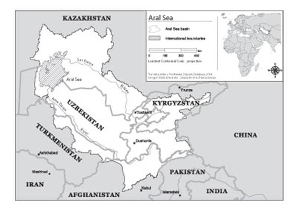
The Aral Sea was, until comparatively recently, the fourth largest inland body of water in the world. Its basin covers 1.8 million km2 , primarily in what used to be the Soviet Union, and what is now the independent republics of Kazakhstan, Kyrgyzstan, Tajikistan, Turkmenistan, and Uzbekistan. Small portions of the basin headwaters are also located in Afghanistan, Iran, and China. The major sources of the Sea, the Amu Darya and the Syr Darya, are fed from glacial meltwater from the high mountain ranges of the Pamir and Tien Shan in Tajikistan and Kyrgyzstan. The environmental problems of the Aral Sea basin are among the worst in the world. Water diversions, agricultural practices, and industrial waste have resulted in a disappearing sea, salinization, and organic and inorganic pollution. The problems of the Aral, which previously had been an internal issue of the Soviet Union, became international problems in 1991. The five new major riparians- Kazakhstan, Kyrgyzstan, Tajikistan, Turkmenistan, and Uzbekistan-have been struggling since that time to help stabilize, and eventually to rehabilitate, the watershed. In February 1992, the five republics negotiated an agreement to coordinate policies on their transboundary waters. Subsequent agreements in the 1990s and in 2002 have updated policies and reorganized transboundary water management institutions. As a result the atmosphere gained from the Heads of State of the Aral Sea Basin nations and their recognition that the benefits of cooperation are much higher than that of competition, interstate water management has been coupled with broader economic agreements including trade of hydroelectric energy and fossil fuel to promote regional goals.
Natural, Historic, Economic, Regional, and Political Framework
 Image 1. Map of the Aral Sea and its tributaries, notably the Syr Darya and Amu Darya.[1]
Analysis, Synthesis, and Insight
Individuals may add their own Analysis, Synthesis, and Insight (ASI) to a case. ASI sub-articles are protected, so that each contributor retains authorship and control of their own content. Edit the case to add your own ASI.
Learn moreASI:The role of economic entities, trust, and credibility in resolving the Aral Sea Crisis
Contributed by: Aaron T. Wolf, Joshua T. Newton, Matthew Pritchard (last edit: 12 February 2013)
- ^ Product of the Transboundary Freshwater Dispute Database, Department of Geosciences, Oregon State University. Additional information about the TFDD can be found at:http://www.transboundarywaters.orst.edu/research/case_studies/Aral_Sea_New.htm


