Integrated Joint Management Agreements of Mekong River Basin Riparians
| Geolocation: | 18° 17' 47.094", 103° 56' 0.9352" |
|---|---|
| Total Population | 1010,000,000 millionmillion |
| Total Area | 787,800787,800 km² 304,169.58 mi² km2 |
| Climate Descriptors | Moist tropical (Köppen A-type), Humid mid-latitude (Köppen C-type), Moist |
| Predominent Land Use Descriptors | agricultural- cropland and pasture, industrial use, urban- high density |
| Important Uses of Water | Agriculture or Irrigation, Domestic/Urban Supply, Hydropower Generation |
Contents
Summary
The Mekong is the seventh largest river in the world in terms of discharge (tenth in length), rising in China, then flowing 4200 kilometers through Myanmar, Laos, Thailand, Cambodia, and finally through the extensive delta in Vietnam into the South China Sea. It is also both the first successful application of comprehensive approach to planning development of an international river and, at the same time, is one of the least developed major rivers in the world, in part because of difficulties inherent in implementing joint management between these the diverse riparians. In 1947, the United Nations Economic Commission for Asia and the Far East (ECAFE) was created to help with the development of Southeast Asia. A 1952 ECAFE study, undertaken with the cooperation of the four lower riparians - Cambodia , Laos , Thailand, Vietnam - noted the Mekong 's particular potential for hydroelectric and irrigation development. The U.S. Bureau of Reclamation performed a report on planning and development on the lower basin in 1955-56, which urged joint management in developing the river, to which the four lower riparians agreed. When the report was presented in the tenth-anniversary meeting of ECAFE in Bangkok in March 1957, representatives from the four lower riparian states themselves adopted resolution calling for further study.
More recently, however, the liberalization of China’s economy, population growth, demand for increased agriculture yields, growing household demand of water for consumption and sanitation, and shortages of electricity has incited Chinese officials to look to the potential of the Mekong's Upper Basin. This unilateral development project alone would have large implications for the downstream riparian states. In the absence of basin-wide consensus and cooperation, these unilateral developments have the potential to make the hydropolitics in the Mekong basin much more contentious. [1]
Natural, Historic, Economic, Regional, and Political Framework
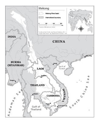
 Figure 1. Map of the Mekong River Basin [2]
Background
The Mekong is the seventh largest river in the world in terms of discharge (tenth in length), rising in China, then flowing 4200 kilometers through Myanmar, Laos, Thailand, Cambodia, and finally through the extensive delta in Vietnam into the South China Sea. It is also both the first successful application of comprehensive approach to planning development of an international river and, at the same time, is one of the least developed major rivers in the world, in part because of difficulties inherent in implementing joint management between these the diverse riparians.
In 1947, the United Nations Economic Commission for Asia and the Far East (ECAFE) was created to help with the development of Southeast Asia. A 1952 ECAFE study, undertaken with the cooperation of the four lower riparians - Cambodia, Laos, Thailand, Vietnam - noted the Mekong 's particular potential for hydroelectric and irrigation development. These recommendations could not be acted upon until the signing of the Geneva Accords in 1954 ended hostilities in the region.
The U.S. Bureau of Reclamation performed a report on planning and development on the lower basin in 1955-56, which urged joint management in developing the river, to which the four lower riparians agreed. The study noted the almost total absence of data necessary for river basin planning; emphasized the need to get a program for data collection and analysis underway immediately; and offered suggestions for the types of programs which should be implemented.
A 1957 ECAFE report concurred with the optimistic potential noted in earlier studies. The report noted that harnessing the main stem of the river would allow hydropower production, expansion of irrigated land, a reduction of the threat of flooding in the delta region, and the extension of navigability of the river as far as northern Laos. As earlier studies had, the ECAFE report emphasized the need for comprehensive development of the river, and close cooperation between the riparians in coordinating efforts for projects and management. To facilitate coordination, the report suggested the establishment of an international body for exchanging information and development plans between the riparian states. Ultimately, the report suggested, such a body might become a permanent agency responsible for coordinating joint management of the Mekong basin. When the report was presented in the tenth-anniversary meeting of ECAFE in Bangkok in March 1957, representatives from the four lower riparian states themselves adopted resolution calling for further study.
The Problem
As is common in international river basins, integrated planning for efficient watershed management is hampered by the difficulties of coordinating between riparian states with diverse and often conflicting needs. The Mekong, however, is noted mostly for the exceptions as compared with other basins, rather than the similarities. The Mekong, for example, is not an exotic stream, and consequently does not have the sharp management conflicts between well-watered upstream riparians and their water-poor downstream neighbors as, for instance, the Euphrates and the Nile. Historically, the two uppermost riparians, China and Myanmar, have not been participants in basin planning, and they have had no development plans which would disrupt the downstream riparians until very recently. Also, because the region is so well-watered, allocations per se are not been a major issue. Finally, negotiations for joint management of the Mekong were not set off by a flashpoint, as were all of the other examples presented in this work, but rather by creativity and foresight on the part of an authoritative third party - the United Nations - with the willing participation of the lower riparian states.
More recently, however, the liberalization of China’s economy, population growth, demand for increased agriculture yields, growing household demand of water for consumption and sanitation, and shortages of electricity has incited Chinese officials to look to the potential of the Mekong's Upper Basin. It is not, therefore, surprising that China would like to fully develop the Upper Mekong Basin and has proposed the building of 15 dams for hydroelectric power.[1] This unilateral development project alone would have large implications for the downstream riparian states. In the absence of basin-wide consensus and cooperation, these unilateral developments have the potential to make the hydropolitics in the Mekong basin much more contentious.[1] The completion of two major dams on the Chinese part of the Lacang-Mekong mainstream, and the prospect of six or seven more hydropower dams in that area, coupled with the recent in navigability along the Mekong (by blasting the rapids and rocks) underline the urgent need to build and appropriate legal framework and to formulate technical guidelines conducive to turning these potential conflicts into opportunities for sharing benefits.
Attempts at Conflict Management
As noted, the 1957 ECAFE study was met with enthusiasm by the lower Mekong riparians. In mid-September 1957, after ECAFE's legal experts had designed a draft charter for a "Coordination Committee," the lower riparians convened again in Bangkok as a "Preparatory Commission." The Commission studied, modified, and finally endorsed a statute, which legally established the Committee for Coordination of Investigations of the Lower Mekong (Mekong Committee), made up of representatives of the four lower riparians, with input and support from the United Nations. The statute was signed on September 17, 1957.
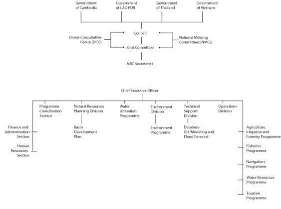
The Committee was composed of "plenipotentiary" representatives of the four countries, meaning that each representative had the authority to speak for their country. The Committee was authorized to, "promote, coordinate, supervise, and control the planning and investigation of water resources development projects in the Lower Mekong Basin." The statute included authority to prepare and submit to participating governments plans for carrying out coordinated research, study, and investigation; make requests on behalf of the participating governments for special financial and technical assistance and receive and administer separately such financial and technical assistance as may be offered under the technical assistance program of the United Nations, the specialized agencies, and friendly governments; draw up and recommend to participating governments criteria for the use of the water of the main river for the purpose of water resources development. It was determined that all meetings must be attended by a representative from each of the four countries, and each decision must be unanimous. Meetings would be held three to four times a year, and chairmanship would rotate annually in alphabetical order by country (Figure 2).
The first Committee session was on October 31, 1957, as was the first donation from the international community-60 million francs (about US$120,000) from France. In late 1957, the Committee, recognizing that data collection was a crucial prerequisite to comprehensive watershed development, asked the UN Technical Assistance Administration to organize a high-level study of the basin. Before the year was out, a mission headed by Lt. General Raymond Wheeler, who had been the deputy commander of the Allied bases in the region during World War II, and later Chief of the U.S. Army Corps of Engineers, arrived in Bangkok.
The principal recommendation of the Wheeler Mission was that, while reaffirming the great potential of water resources development, suggesting that, properly developed, the river, "could easily rank with Southeast Asia’s greatest natural resources," the absence of data required that a series of detailed hydrographic studies precede any construction. The mission recommended a five-year program of study, to cost approximately $9 million (Table 2).
 Figure 2. Organization chart of the Mekong Committee.[2]
Analysis, Synthesis, and Insight
Individuals may add their own Analysis, Synthesis, and Insight (ASI) to a case. ASI sub-articles are protected, so that each contributor retains authorship and control of their own content. Edit the case to add your own ASI.
Learn moreNo ASI articles have been added yet for this case
- ^ 1.0 1.1 1.2 Elhance, A. P. (1999). Hydropolitics in the 3rd World, Conflict and Cooperation in International River Basins. Washington DC: United States Institute of Peace.
- ^ 2.0 2.1 Product of the Transboundary Freshwater Dispute Database, Department of Geosciences, Oregon State University. Additional information about the TFDD can be found at: <http://www.transboundarywaters.orst.edu.


