International Joint Development of The La Plata River Basin
| Geolocation: | -24° 9' 9.6689", -55° 22' 8.8306" |
|---|---|
| Total Population | 6767,000,000 millionmillion |
| Total Area | 2,954,5002,954,500 km² 1,140,732.45 mi² km2 |
| Climate Descriptors | Moist tropical (Köppen A-type), Humid mid-latitude (Köppen C-type), Moist |
| Predominent Land Use Descriptors | agricultural- cropland and pasture, industrial use, forest land, urban |
| Important Uses of Water | Agriculture or Irrigation, Hydropower Generation, Other Ecological Services |
Contents
Summary
Natural, Historic, Economic, Regional, and Political Framework
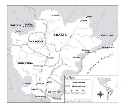
 Figure 1. Map of the La Plata River Basin [1]
Background
The La Plata River basin encompasses an area of 3.2 million square kilometers and is among the five largest international rivers basins in the world. It includes territory in Argentina, Bolivia, Brazil, Paraguay, and Uruguay, comprises the Parana, Paraguay and Uruguay River systems and makes up the largest wetland in the world-the Pantanal. The basin is the life sustenance for much of the agricultural and industrial sectors of the riparian states and has become a source of alternative energy and economic possibility.
The Basin's five riparian states have a history of cooperation and joint management of the watershed, and have stressed the river's binding them to each other. Bolivia, Paraguay and Uruguay’s agriculture economies depend on the basin as crucially as the industrial sectors of Argentina and Brazil. Large amounts of grain, beef, wool, timber and some manufacturing goods are exported from this region to other parts of the world. [2] The 1969 La Plata River Basin Treaty, the umbrella treaty and first to which all of the riparians are signatories, provides a framework for joint management, development and preservation of the basin. Subsequent multilateral and bilateral treaties outline the specifics of economic investment, hydro-electric development and transportation enhancement.
Following the 1969 multilateral treaty, bilateral hydroelectric development opportunities were explored which gave source to the construction of dams and alternative power plants along the Parana. Today there are 130 dams along the River, two of which are widely known, the Itaipu and the Yacureta. Itaipu is the largest hydroelectric project in the world and a result of a 1973 bilateral agreement between Paraguay and Brazil. The hydroelectric dam cost the two governments and other international participants US$15 billion and 20 years to construct. The generating capacity is 26,000mW and supplies 26% of all of the electricity for Brazil and 78% for Paraguay with zero emissions.
The political and environmental dimensions of the Itaipu make for an interesting case of cooperation over a shared water resource. The land, where the Itaipu dam now sits, was once a source of great controversy between Brazil and Paraguay. Each country declared rights and legal authority over the Guairá Falls, which lies on the border of both countries and to which both claimed ownership and control. In 1957, Brazil, who believed the Falls to be within their borders and who wanted to invest in the hydroelectric power of the Falls, unilaterally took military control over the region. After five years of dispute and disagreement, Brazil and Paraguay finally negotiated the terms of the Itaipu dam. In addition to providing electricity to the two countries, the proposed project would submerge Guairá Falls [2] thus, marking an end to the border dispute.
This conflict negotiation and cooperation between Brazil and Paraguay had ripple effects into areas of conservation and preservation. When the environmental concerns around the construction of the Itaipu basin came to the forefront, the two countries implemented two joint projects, the Gralha Azul and the Mymba Kuera, to minimize the effects of reservoir flooding on the regions ecology, deforestation in the region and moved the wildlife most affected by the dam to biological reserves. [3]
The Yacyreta Treaty, an agreement between Argentina and Paraguay, to construct a hydroelectric dam downstream from the Itaipu, has not been deemed as successful in its implementation. The treaty was hastily signed in December 1973, very soon after the Itaipu and was similar in content (generated power to be divided evenly between the two nations), except for the Yacyreta allowed for either country to sell power surpluses to a third party Cite error: Closing </ref> missing for <ref> tag Environmentalists and those whose livelihoods depend on traditional economies have expressed trepidation at the project.
Analysis, Synthesis, and Insight
Individuals may add their own Analysis, Synthesis, and Insight (ASI) to a case. ASI sub-articles are protected, so that each contributor retains authorship and control of their own content. Edit the case to add your own ASI.
Learn moreASI:Lessons learned for cooperation between riparians and sectors
Contributed by: Aaron T. Wolf, Joshua T. Newton, Matthew Pritchard (last edit: 12 February 2013)
- ^ Product of the Transboundary Freshwater Dispute Database, Department of Geosciences, Oregon State University. Additional information about the TFDD can be found at: http://www.transboundarywaters.orst.edu
- ^ 2.0 2.1 Elhance, A. P. (1999). Hydropolitics in the 3rd World, Conflict and Cooperation in International River Basins. Washington DC: United States Institute of Peace.
- ^ American University Trade and Environment data base (2004). Itaipu Dam. Available online at http://www.american.edu/TED/itaipu.htm.


