Negotiations and Agreements Between Ganges River Basin Riparians
From AquaPedia Case Study Database
Case Description
| Geolocation: | 26° 27' 44.2894", 87° 31' 23.9059" |
|---|---|
| Total Population | 200200,000,000 millionmillion |
| Total Area | 1,634,9001,634,900 km² 631,234.89 mi² km2 |
| Climate Descriptors | Moist tropical (Köppen A-type), Continental (Köppen D-type), Moist, Monsoon, alpine |
| Predominent Land Use Descriptors | agricultural- cropland and pasture, industrial use, urban- high density, religious/cultural sites |
| Important Uses of Water | Agriculture or Irrigation, Domestic/Urban Supply, Hydropower Generation |
Contents
[hide]Summary
Natural, Historic, Economic, Regional, and Political Framework
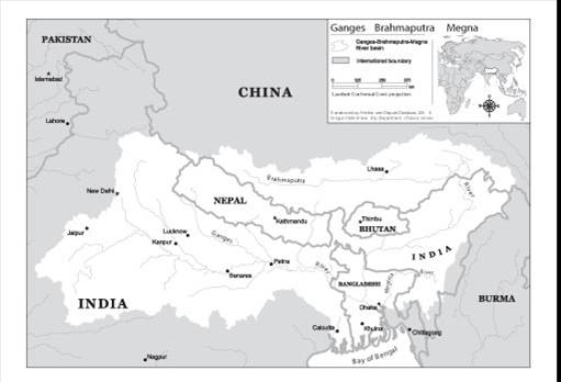
 Map of the Ganges- Brahmaputra-Megna basin. [1]
Analysis, Synthesis, and Insight
What is an ASI?
Individuals may add their own Analysis, Synthesis, and Insight (ASI) to a case. ASI sub-articles are protected, so that each contributor retains authorship and control of their own content. Edit the case to add your own ASI.
Learn moreASI:Ganges Basin: insights from the Transboundary Freshwater Dispute Database
(last edit: 13 November 2012)
- ^ Product of the Transboundary Freshwater Dispute Database, Department of Geosciences, Oregon State University: http://www.transboundarywaters.orst.edu


