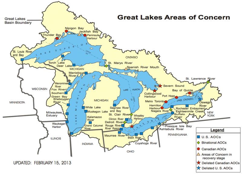
File:GreatLakes-AOC-USEPA.png

Summary
adapted from - http://www.epa.gov/greatlakes/aoc/images/aoc-glbasin-map-20130215.pdf
"The U.S.-Canada Great Lakes Water Quality Agreement (Annex 2 of the 1987 Protocol) defines AOCs as "geographic areas that fail to meet the general or specific objectives of the agreement where such failure has caused or is likely to cause impairment of beneficial use of the area's ability to support aquatic life." More simply put, an AOC is a location that has experienced environmental degradation." - http://www.epa.gov/greatlakes/aoc/
Licensing
This file is considered to be in the public domain. See the file description for any additional details.
Publication of a U.S. Government Entity.
File history
Click on a date/time to view the file as it appeared at that time.
| Date/Time | Thumbnail | Dimensions | User | Comment | |
|---|---|---|---|---|---|
| current | 10:31, 16 May 2014 |  | 1,000 × 719 (151 KB) | Amanda (Talk | contribs) | adapted from - http://www.epa.gov/greatlakes/aoc/images/aoc-glbasin-map-20130215.pdf "The U.S.-Canada Great Lakes Water Quality Agreement (Annex 2 of the 1987 Protocol) defines AOCs as "geographic areas that fail to meet the general or specific object... |
- You cannot overwrite this file.
File usage
The following page links to this file:


