Difference between revisions of "Colorado River"
| [checked revision] | [checked revision] |
| (3 intermediate revisions by one other user not shown) | |||
| Line 1: | Line 1: | ||
{{Water Feature | {{Water Feature | ||
| − | |Type= | + | |Type=river or creek |
| − | |Length= | + | |Located in Region=Northern America |
| − | |Area= | + | |isabasin=yes |
| − | |Description= | + | |Basin Area=637000 |
| + | |Basin Population=30000000 | ||
| + | |Riparian Basin= | ||
| + | |Located in Riparian= | ||
| + | |issurface= | ||
| + | |Water Feature Area= | ||
| + | |Average Discharge= | ||
| + | |Maximum Discharge= | ||
| + | |Minimum Discharge= | ||
| + | |Water Feature Length= | ||
| + | |Within Basin= | ||
| + | |Aquifer Description= | ||
| + | |Recharge Rate= | ||
| + | |Recharge Rate Low= | ||
| + | |Recharge Rate High= | ||
| + | |Recharge Zone Area= | ||
| + | |Groundwater Resource Volume= | ||
| + | |Within System= | ||
| + | |Data References=USGS (1990). Largest Rivers in the United States. Retrieved from: http://pubs.usgs.gov/of/1987/ofr87-242 | ||
| + | |Overview=The Colorado River and its tributaries supply water to 30 million municipal residents, 4 million acres of irrigated farmland and generate more than 4,200 MW of hydropower <ref name=“USBR 2011a”>USBR (2011a). Colorado River Basin Water Supply and Demand Study Program. Retrieved from: http://www.usbr.gov/lc/region/programs/crbstudy/FactSheet_May2011.pdf</ref>. The Colorado River runs 1,450 miles from its headwaters in the Rocky Mountains to the delta in Baja California, Mexico <ref name=“USGS 1990”> USGS (1990). Largest Rivers in the United States. Retrieved from: http://pubs.usgs.gov/of/1987/ofr87-242 </ref>. Its expansive watershed covers 246,000 square miles and spans two countries the United States and Mexico; within the United States the Colorado River watershed includes seven states: Utah, Wyoming, Arizona, Colorado, California, Nevada, and New Mexico <ref name=“USGS 1990”> USGS (1990). Largest Rivers in the United States. Retrieved from: http://pubs.usgs.gov/of/1987/ofr87-242 </ref>. | ||
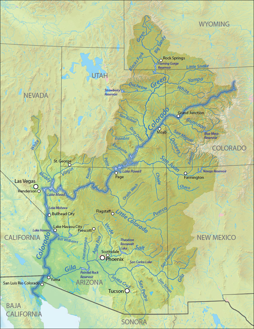
| + | |Description=[[File:Coloradorivermapnew1.jpg|frame | 600px | center| GFDL licensed map of the Colorado River Basin. Click image for source info.]] | ||
|External Links= | |External Links= | ||
| − | |Case Review= | + | |Case Review={{Case Review Boxes |
| − | + | |Empty Section=No | |
| − | {{Case Review Boxes | + | |Clean Up Required=No |
| − | |Empty Section= | + | |Expand Section=No |
| − | |Clean Up Required= | + | |Add References=No |
| − | |Expand Section= | + | |Wikify=No |
| − | |Add References= | + | |connect to www=No |
| − | |Wikify= | + | |Out of Date=No |
| − | |connect to www= | + | |Disputed=No |
| − | |Disputed= | + | |MPOV=No |
|Mpov= | |Mpov= | ||
| + | }} | ||
| + | |Length= | ||
| + | |Area= | ||
}} | }} | ||
Revision as of 14:06, 16 May 2013
Colorado River Facts
Basin Area: 637000 637,000 km²
245,882 mi² km2
Type:river or creek
USGS (1990). Largest Rivers in the United States. Retrieved from: http://pubs.usgs.gov/of/1987/ofr87-242
view/browse all article properties
The Colorado River and its tributaries supply water to 30 million municipal residents, 4 million acres of irrigated farmland and generate more than 4,200 MW of hydropower [1]. The Colorado River runs 1,450 miles from its headwaters in the Rocky Mountains to the delta in Baja California, Mexico [2]. Its expansive watershed covers 246,000 square miles and spans two countries the United States and Mexico; within the United States the Colorado River watershed includes seven states: Utah, Wyoming, Arizona, Colorado, California, Nevada, and New Mexico [3].
Case Studies linked to Colorado River
- Colorado River Basin Shortages and Coordinated Operations for Lake Powell and Lake Mead
- The Upper Colorado River Endangered Fish Recovery and San Juan River Basin Recovery Implementation Programs
- Water Competition & Cooperation in the Las Vegas Valley
Articles linked to Colorado River
| Riparians | Water Features |
|---|---|
|
Located in this basin- The United States of America
|
|
| Projects and Initiatives | Agreements and Treaties |
|---|---|
|
|
|
| Riparian | Population in Basin | Area within Basin in sq. km | Irrigated Lands within Basin in sq km | Average Discharge in cubic m per second |
|---|---|---|---|---|
| The United States of America | 644,358 km²248,788.015 mi² | 3,800 km²1,467.188 mi² | 158,443.823 m³/s5,595,390.8 cfs 5,000.012 km³/y | |
| Mexico | 10,809 km²4,173.378 mi² | 25,800 km²9,961.436 mi² | 0 m³/s0 cfs 0 km³/y |
- ^ USBR (2011a). Colorado River Basin Water Supply and Demand Study Program. Retrieved from: http://www.usbr.gov/lc/region/programs/crbstudy/FactSheet_May2011.pdf
- ^ USGS (1990). Largest Rivers in the United States. Retrieved from: http://pubs.usgs.gov/of/1987/ofr87-242
- ^ USGS (1990). Largest Rivers in the United States. Retrieved from: http://pubs.usgs.gov/of/1987/ofr87-242


