File list
This special page shows all uploaded files.
| Date | Thumbnail | Size | User | Description | Versions | |
|---|---|---|---|---|---|---|
| 10:41, 25 May 2017 | -Chart-01-SouthChinaSea Figures-.png (file) |  |
328 KB | Pjular | 1 | |
| 10:38, 25 May 2017 | -MAP-01 SouthChinaSea MaritimeTerritory-.jpg (file) |  |
205 KB | Pjular | 1 | |
| 10:30, 25 May 2017 | -MAP-02 SouthChinaSea Nine dash line claim-.jpg (file) |  |
544 KB | Pjular | 1 | |
| 10:38, 25 May 2017 | -MAP-03 SouthChinaSea Nine dash line historical map-.gif (file) |  |
463 KB | Pjular | 1 | |
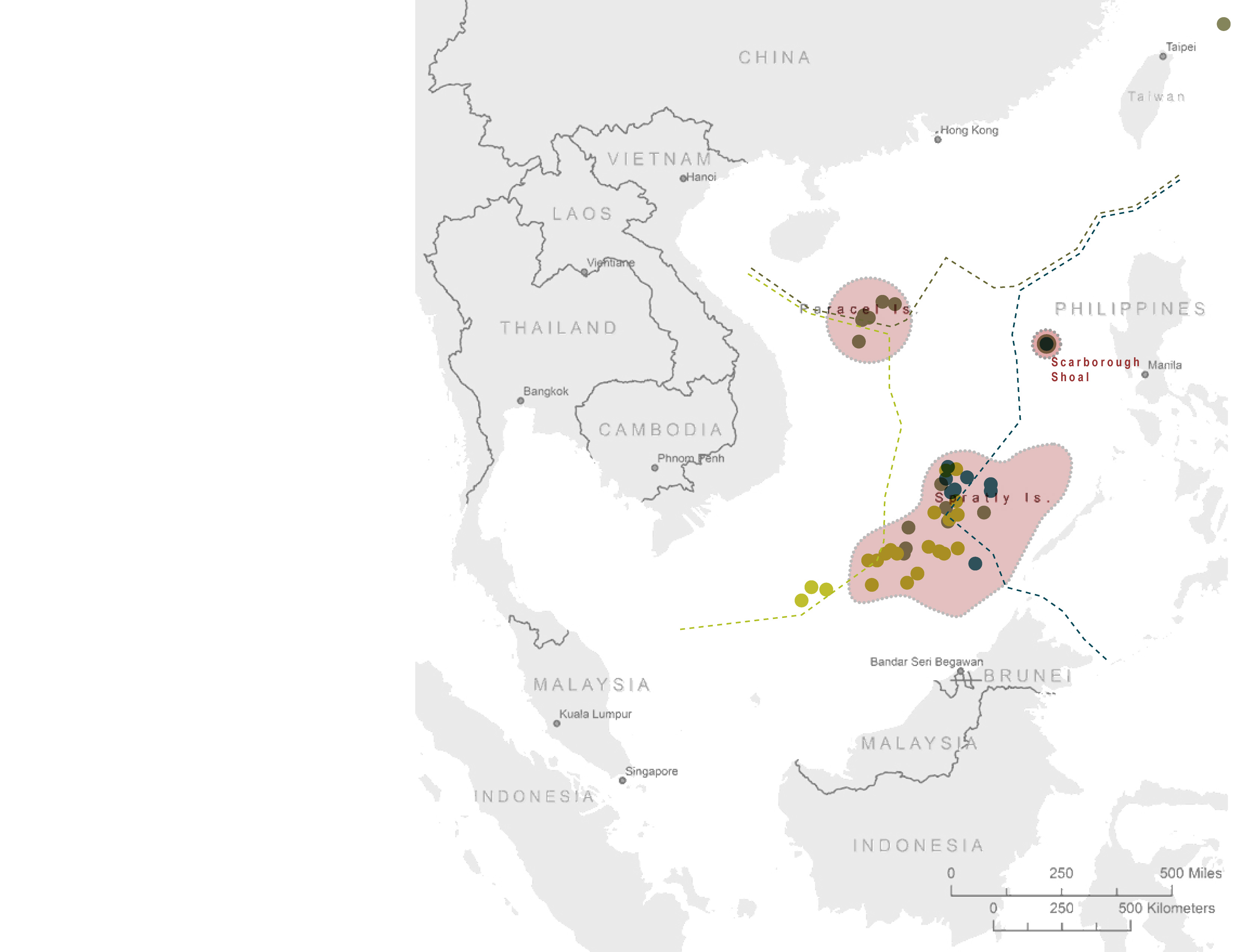
| 10:37, 25 May 2017 | -MAP-04 SouthChinaSea Islands in dispute-.jpg (file) |  |
353 KB | Pjular | 1 | |
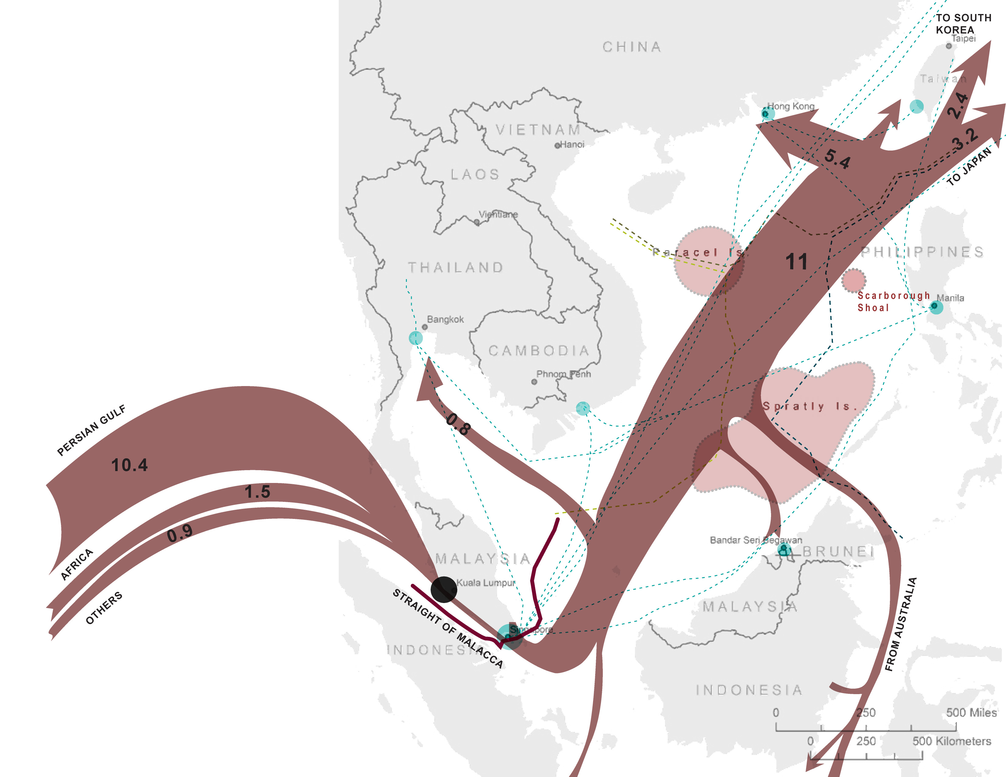
| 10:39, 25 May 2017 | -MAP-05 SouthChinaSea Crude oil trade flow-.jpg (file) |  |
671 KB | Pjular | 1 | |
| 10:40, 25 May 2017 | -MAP-06 SouthChinaSea Oil and Natural Gas Platform-.jpg (file) |  |
487 KB | Pjular | 1 | |
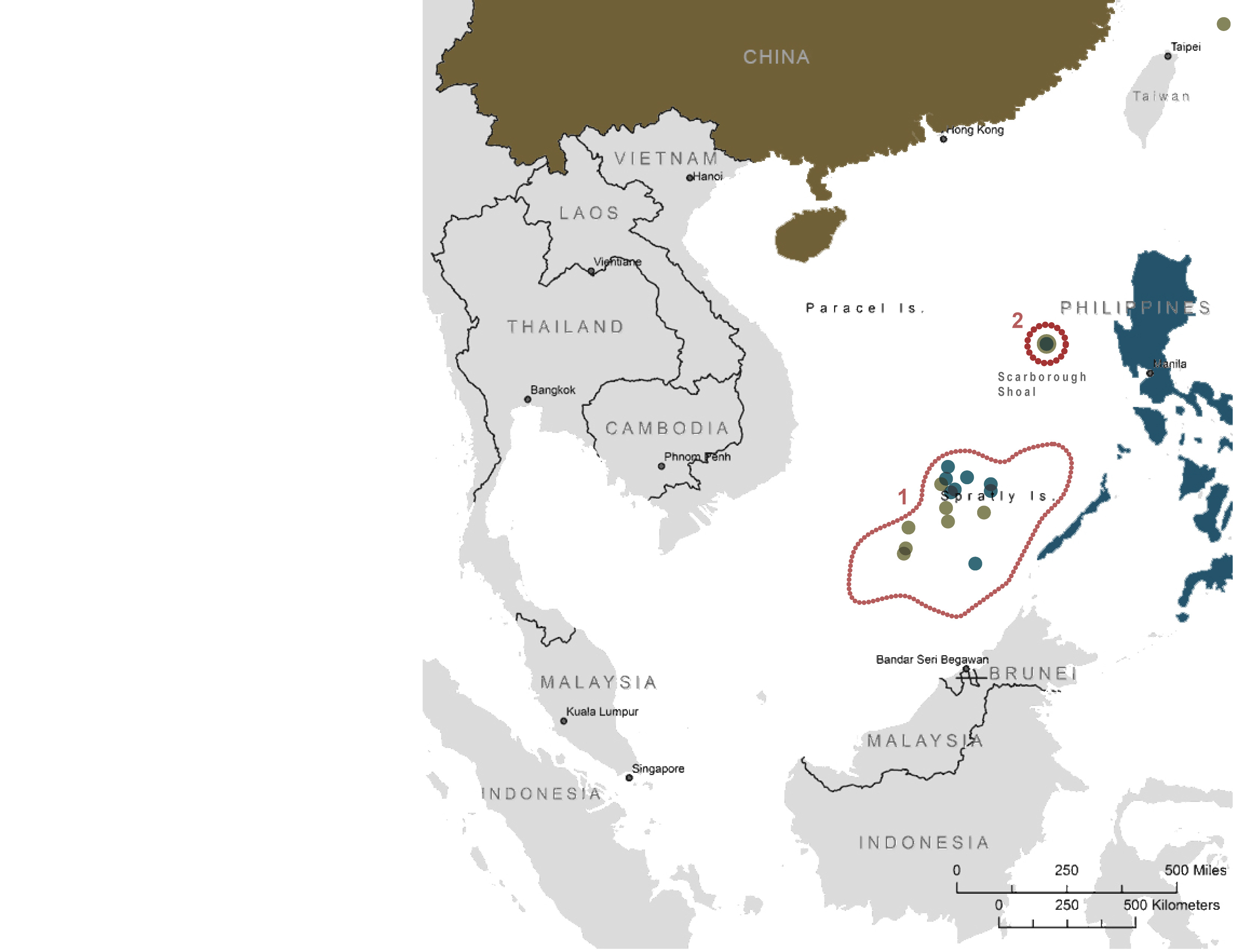
| 10:40, 25 May 2017 | -MAP-07 SouthChinaSea ChinavsPhilippines-.jpg (file) |  |
411 KB | Pjular | 1 | |
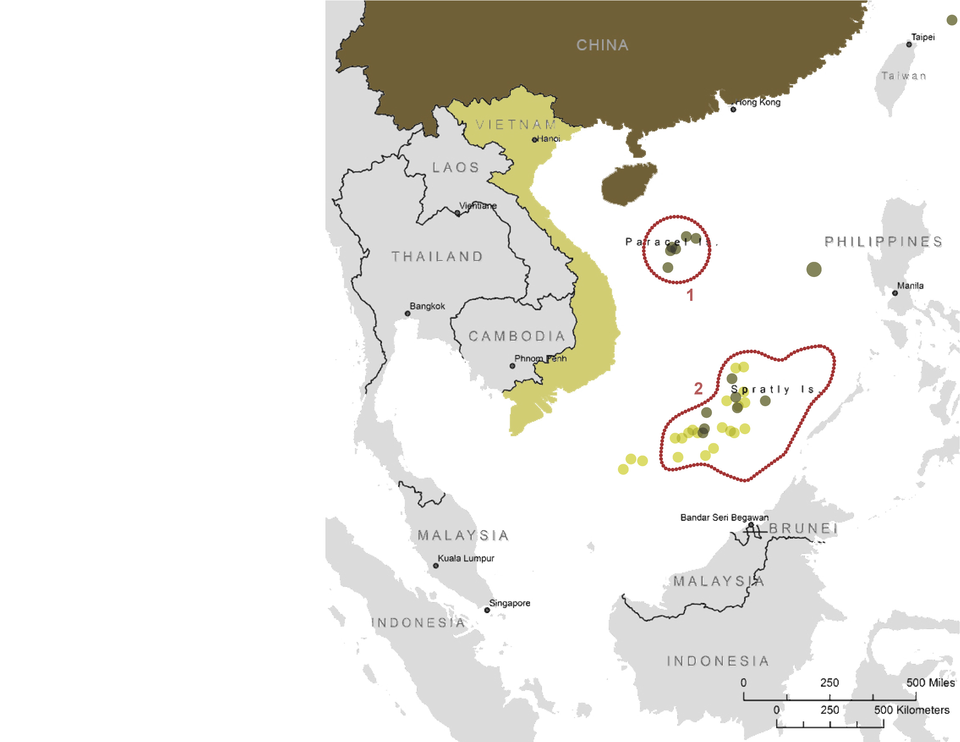
| 10:41, 25 May 2017 | -MAP-08 SouthChinaSea ChinavsVietnam-.jpg (file) |  |
419 KB | Pjular | 1 | |
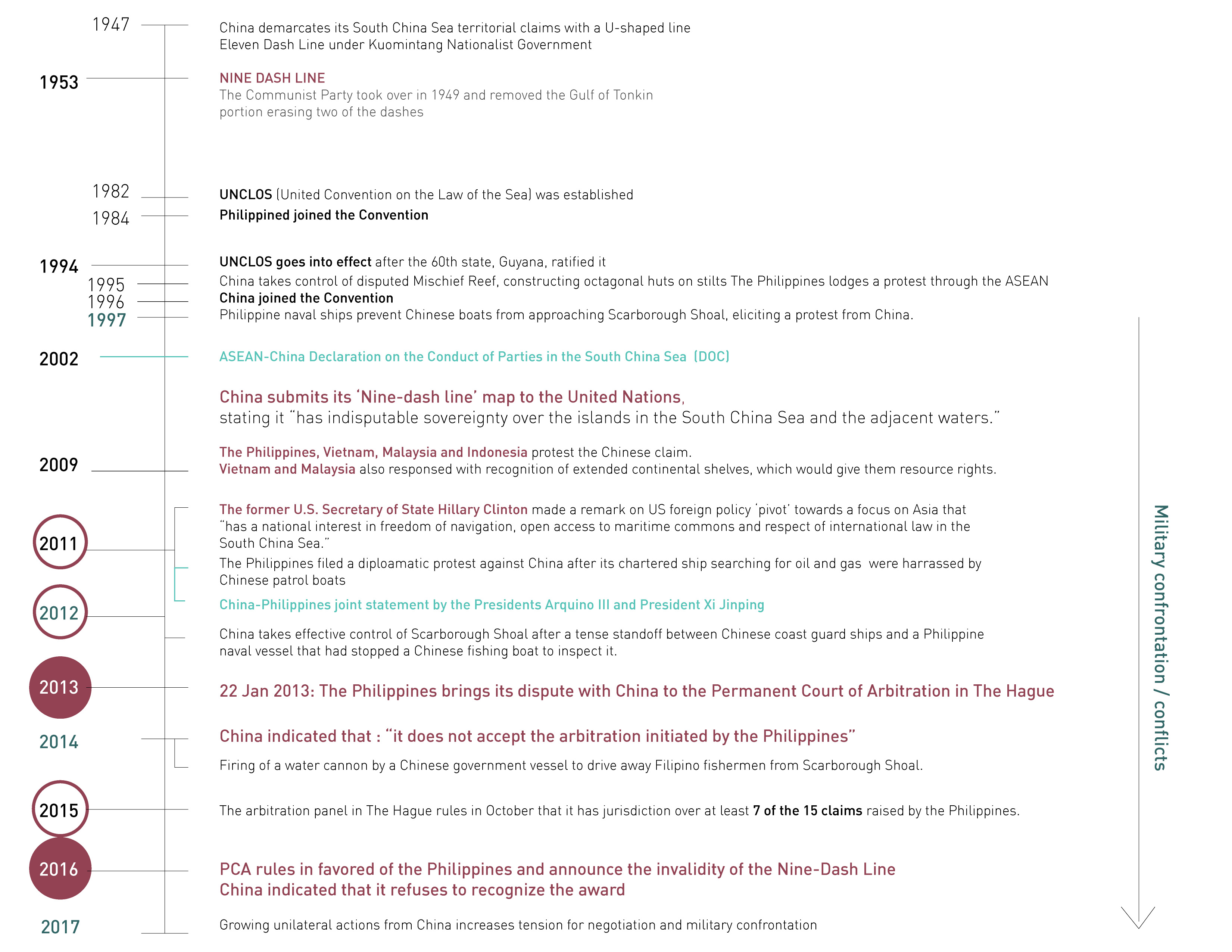
| 10:41, 25 May 2017 | -Timeline01 SouthChinaSea ChinavsPhilippines-.jpg (file) |  |
874 KB | Pjular | 1 | |
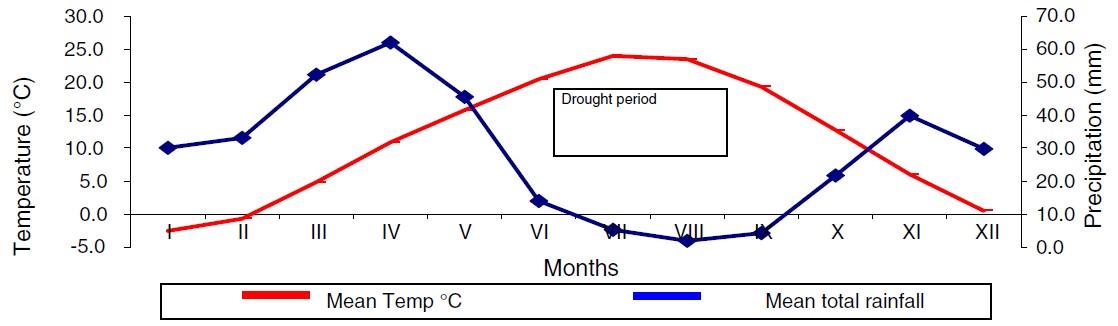
| 10:40, 28 January 2015 | 1.jpg (file) |  |
62 KB | Zarghami | Ombrothermic diagram of Urmia station by using Emberger method, and precipitation and potential evapotranspiration, Urmia station (Delju et al 2013) | 1 |
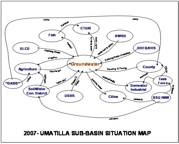
| 12:05, 27 July 2012 | 2007Umatillasubbasinsituationmap.jpg (file) |  |
46 KB | Mpritchard | Preliminary depiction of stakeholders and linkages for the groundwater situation in the Umatilla Basin, Northwestern US. “OASIS” was a proposed project to divert water from the Columbia River. DLCD denotes the Oregon Department of Land and Conservatio | 1 |
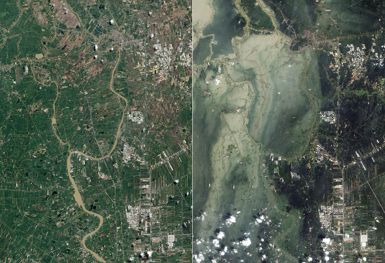
| 22:46, 10 May 2014 | 7.jpg (file) |  |
419 KB | TSP | 2011 Thailand Flood Satellite Photo Source: http://en.wikipedia.org/wiki/2011_Thailand_floods | 1 |
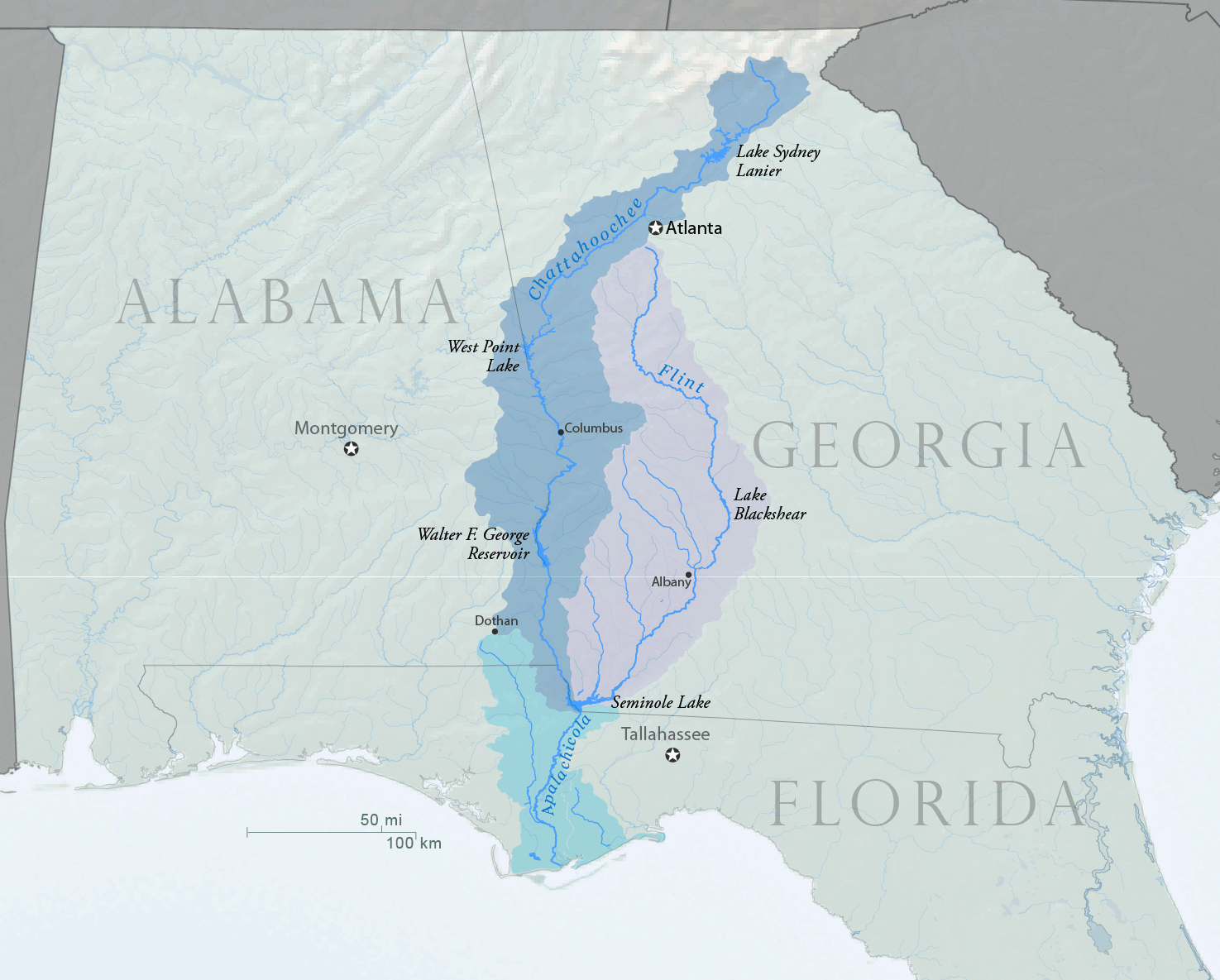
| 11:39, 10 October 2013 | ACF-overview.png (file) |  |
431 KB | Amanda | Map overview showing ACF (Apalachicola-Chattahoochee-Flint) Basin and major reservoirs within the basin. Created by Water Diplomacy using USGS and U.S. Census Bureau Data sources in October 2013. | 1 |
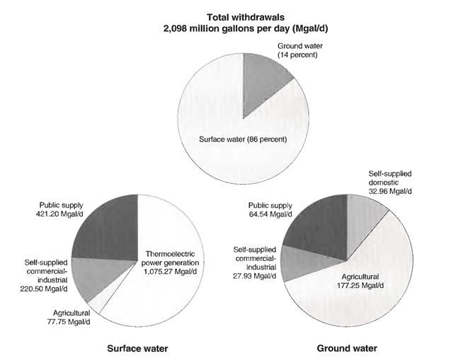
| 16:30, 28 February 2013 | ACF-total-withdrawal-pie-chart.png (file) |  |
55 KB | Amanda | This is figure 29. Ground- and surface-water withdrawals by principal water use-categories in the Apalachicola-Chattahoochee-Flint River basin, 1990 (data from Marella andothers, 1993) which appeared in Influences of environmental settings on aquatic ecos | 1 |
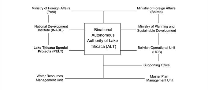
| 17:01, 27 August 2012 | ALTorgchart.jpg (file) |  |
18 KB | Mpritchard | Wide use of electronic and hardcopy versions of data, GIS coverages, and findings produced by the Transboundary Freshwater Dispute Database (TFDD) project is encouraged. The data, coverages, and findings are not copyrighted, although due credit is apprec | 1 |
| 16:07, 25 January 2013 | AP-screenshot-WMC.png (file) |  |
92 KB | Amanda | Screenshot showing how to incorporate a file from Wikimedia Commons into an AquaPedia Case | 1 |
| 12:57, 14 May 2014 | Abstract.docx (file) | 13 KB | Jcheung6 | 1 | ||
| 14:00, 7 May 2012 | Add.png (file) |  |
4 KB | Administrator | 1 | |
| 14:48, 13 June 2012 | Add icon.png (file) | 14 KB | Amanda | 1 | ||
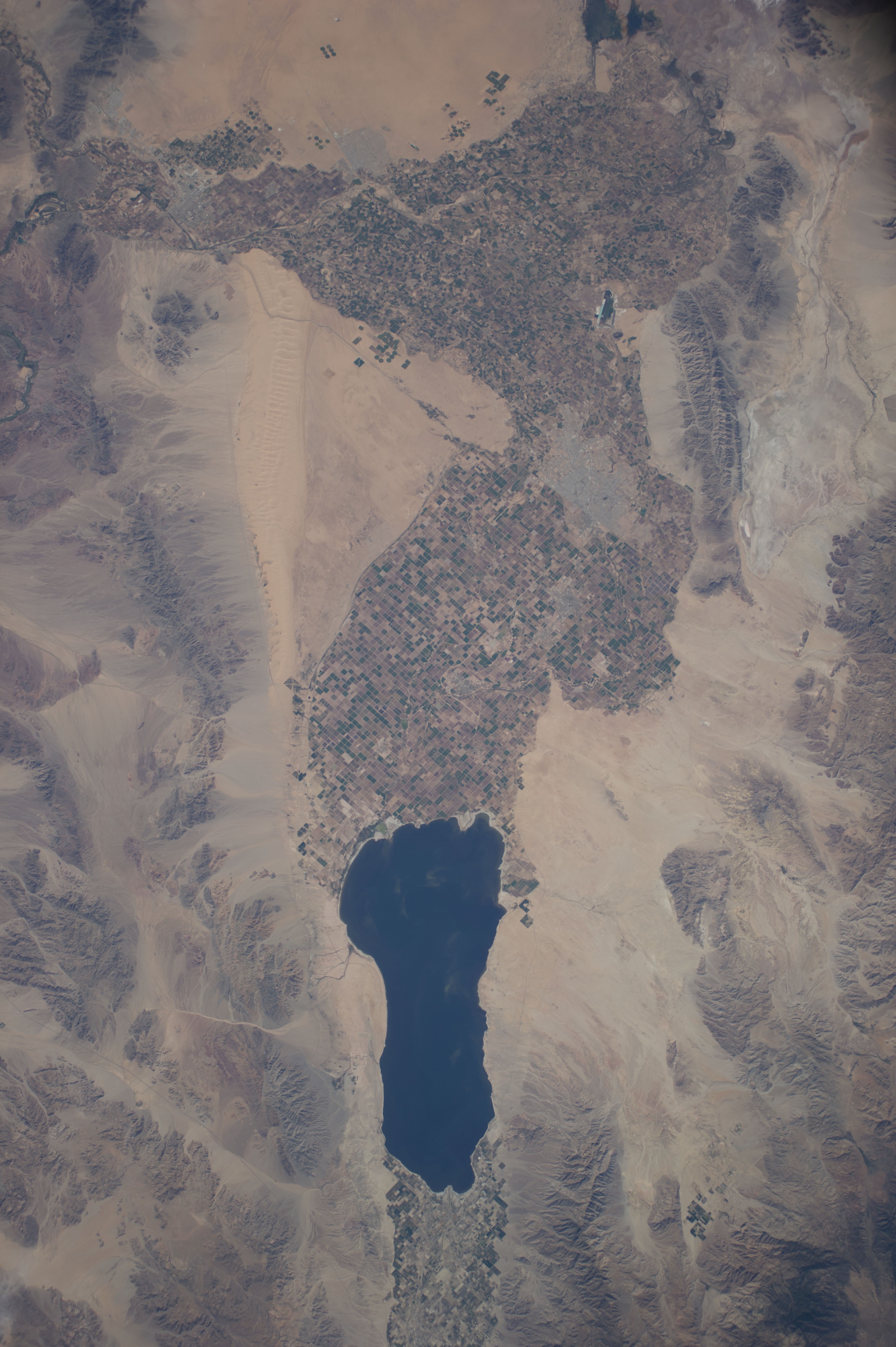
| 17:07, 18 January 2016 | Aerial1.jpg (file) |  |
1.89 MB | JRozek | Source: https://www.flickr.com/photos/nasa2explore/14943033928 License: https://creativecommons.org/licenses/by-nc/2.0/ | 1 |
| 15:31, 7 January 2013 | AquaPedia-Screenshot-case1.png (file) |  |
50 KB | Amanda | Screenshot with notation showing some of the parts of a case study. | 1 |
| 16:07, 7 January 2013 | AquaPedia-Screenshot-case2.png (file) |  |
78 KB | Amanda | CC by SA 3.0 Screenshot showing case study sections. | 1 |
| 16:30, 7 January 2013 | Aquapedia-screenshot-explain-tabs-links.png (file) |  |
492 KB | Amanda | An explanation of navigation tabs for cases and overall navigation via annotated screenshot. CC by SA 3.0 | 2 |
| 13:41, 25 January 2013 | Aquapedia-screenshot-pending-changes-tab.png (file) | 21 KB | Amanda | screenshot of AquaPedia page tabs showing the "Pending Changes" tab | 1 | |
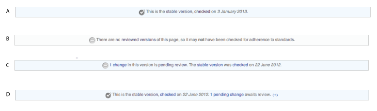
| 16:33, 7 January 2013 | Aquapedia-screenshot-review-status-options.png (file) |  |
27 KB | Amanda | screenshots showing various Case or Article Review Statuses | 1 |
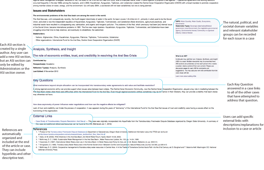
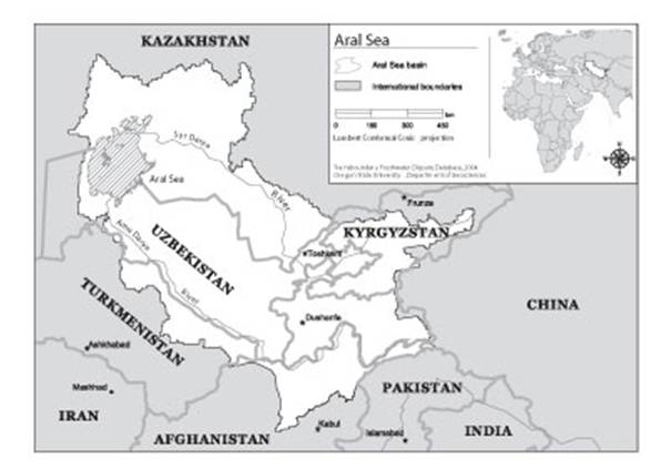
| 15:26, 21 August 2012 | Aral Sea.jpg (file) |  |
28 KB | Mpritchard | Wide use of electronic and hardcopy versions of data, GIS coverages, and findings produced by the Transboundary Freshwater Dispute Database (TFDD) project is encouraged. The data, coverages, and findings are not copyrighted, although due credit is apprec | 1 |
| 11:48, 15 May 2013 | Arrows-ffffff.png (file) |  |
4 KB | ACR | 2 | |
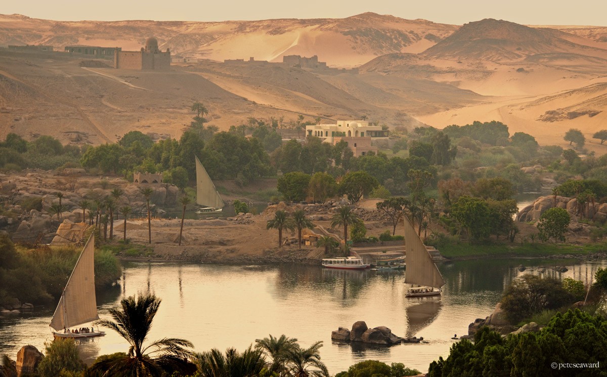
| 17:15, 21 December 2015 | Aswan02.jpg (file) |  |
245 KB | Agustinbotteron | Source:http://www.peteseaward.com/_themes/pete_seaward/watermark.php?photo=110_main_large.jpg&dir=galleries | 1 |
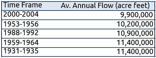
| 10:16, 16 May 2013 | AverageAnnualColoradoUSFlows.jpg (file) |  |
27 KB | Amanda | Produced 2013 by Margaret Garcia for Water Competition & Cooperation in the Las Vegas Valley | 1 |
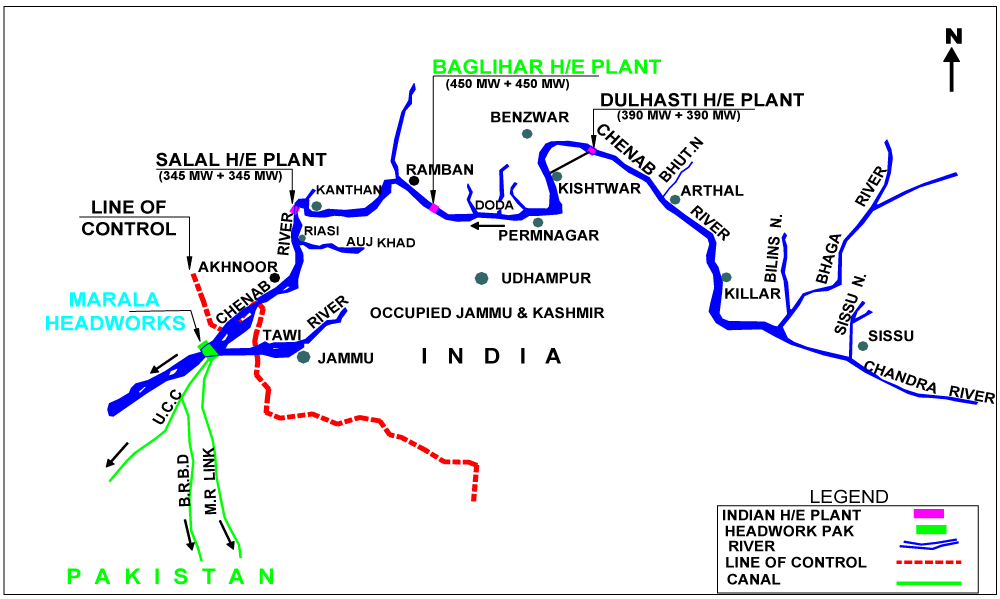
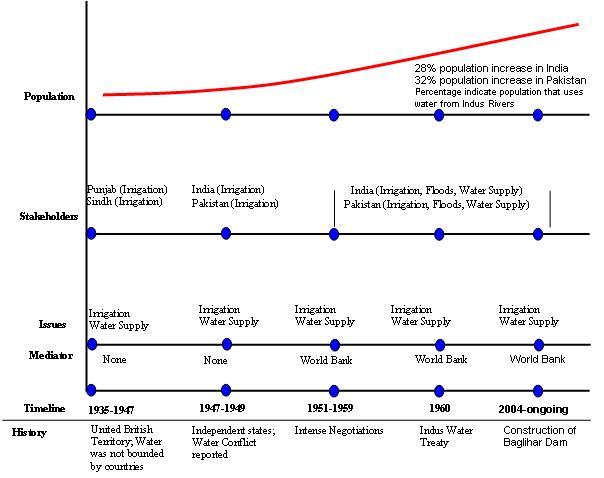
| 09:15, 30 January 2015 | Baglihar Dam on Chenab river.png (file) |  |
36 KB | Ashfaqm | image included in slide 11 from Mahmoud, A. 2014. Hydro-diplomacy to Address the Transboundary Water Issues between India and Pakistan Presentation from IUCN 2nd National Consultative Workshop on Pakistan Water Issues (3 June 2014) Available from: htt... | 1 |
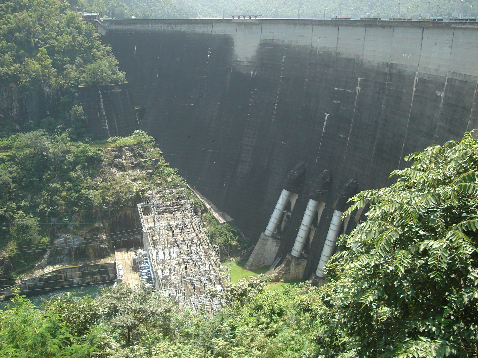
| 21:03, 30 April 2014 | Bhumibol dam front.jpg (file) |  |
490 KB | TSP | Exhibit 3: Bhumipol Dam Source: http://en.wikipedia.org/wiki/Bhumibol_Dam | 1 |
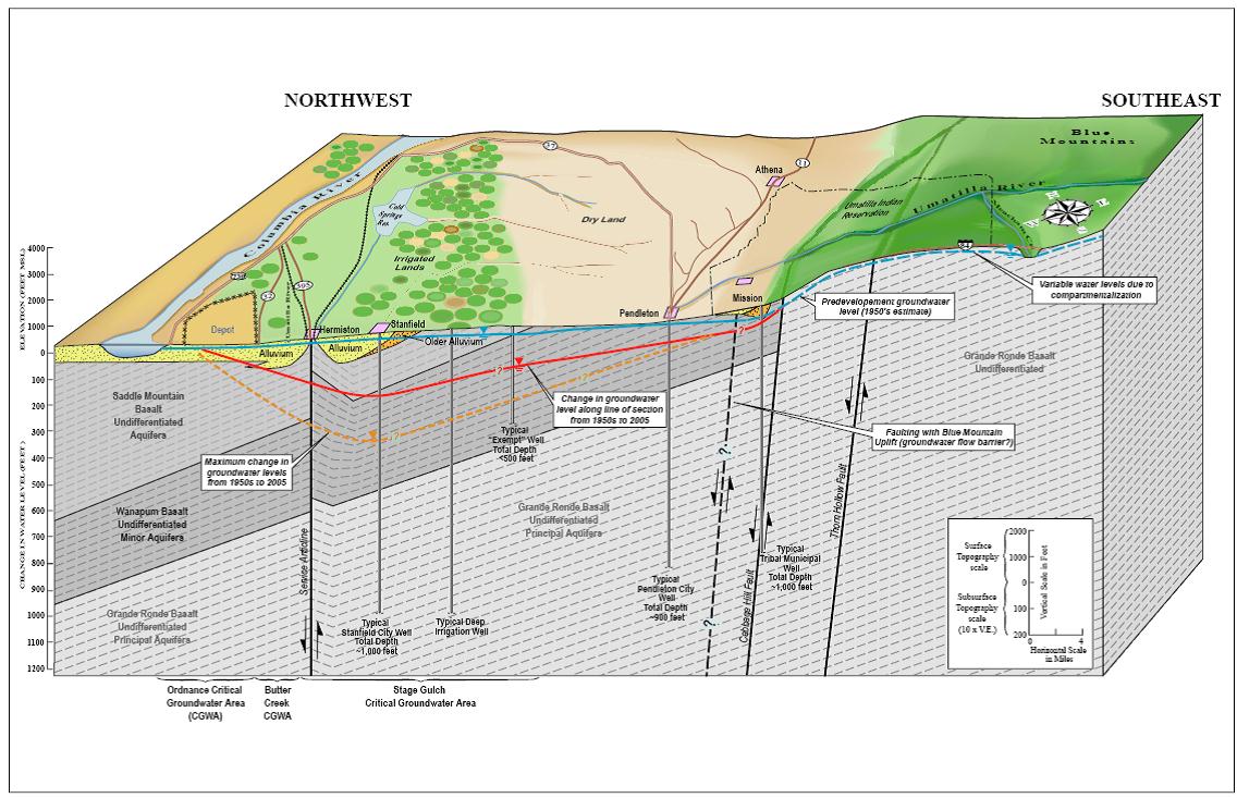
| 11:56, 27 July 2012 | BlockdiagramofUmatillaBasinhydrogeology.jpg (file) |  |
171 KB | Mpritchard | “Product of the Transboundary Freshwater Dispute Database, Department of Geosciences, Oregon State University. Additional information about the TFDD can be found at: <http://www.transboundarywaters.orst.edu>.” | 1 |
| 22:36, 26 March 2012 | British Administration.jpg (file) |  |
65 KB | Administrator | 1 | |
| 15:00, 2 July 2012 | Broom-icon.png (file) | 2 KB | Amanda | Broom Icon created specifically for AquaPedia. Released under CC-BY-SA 3.0 | 1 | |
| 14:34, 31 July 2014 | Buesser, Christine - Gaza Water Management Presentation MIT May 2014 external use.pdf (file) | 1.61 MB | Amanda | Slides from a presentation by Christine Buesser, at MIT for the 2014 Spring Semester Water Diplomacy course, May 15, 2014 Images within the presentation are subject to the copyright of their original source. This file is included here because it i... | 1 | |
| 13:25, 17 May 2013 | CAN-US-Boundary-Waters.jpg (file) |  |
185 KB | Cvanrees | An image taken from the IJC website mapping transboundary waters and watersheds on the U.S. Canada border. | 1 |
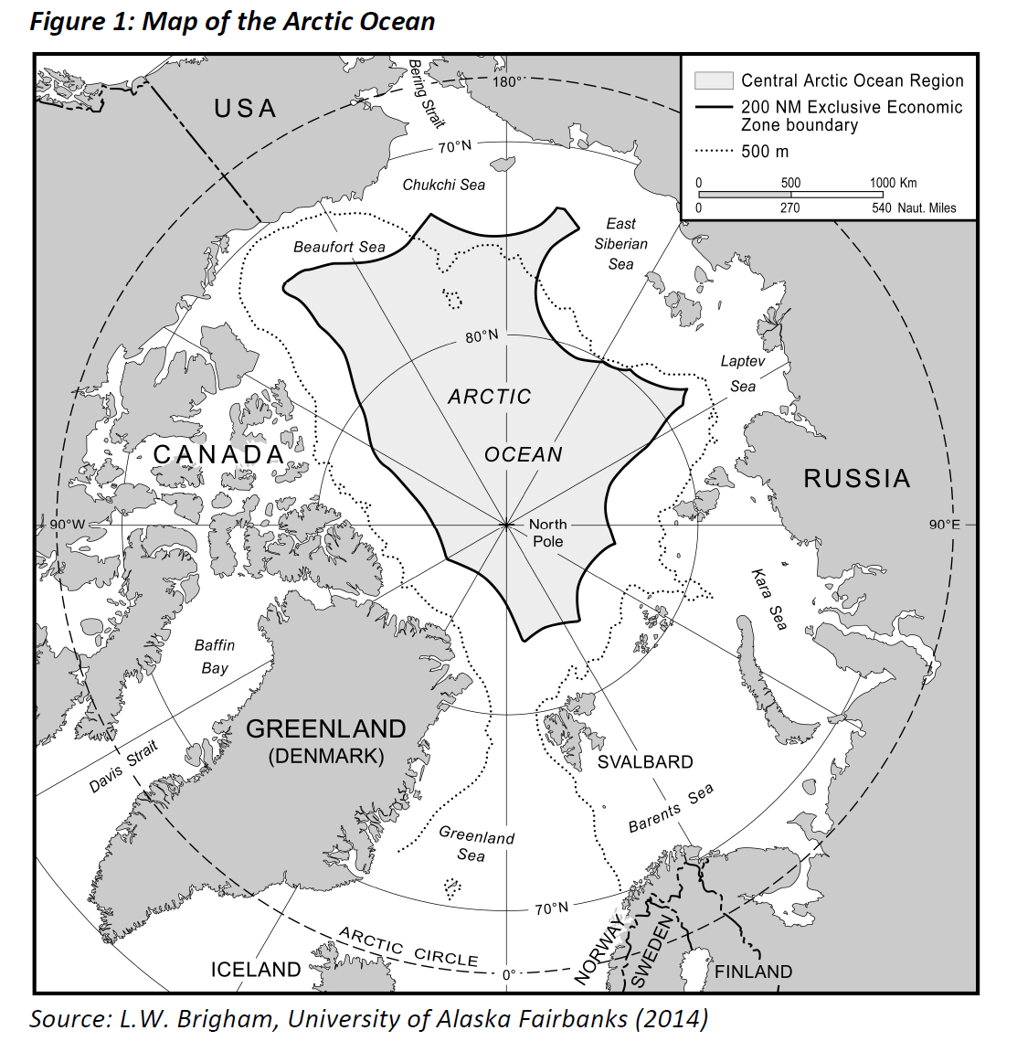
| 09:53, 18 May 2017 | CAO.png (file) |  |
392 KB | Akaush02 | Map of the Arctic Ocean | 1 |
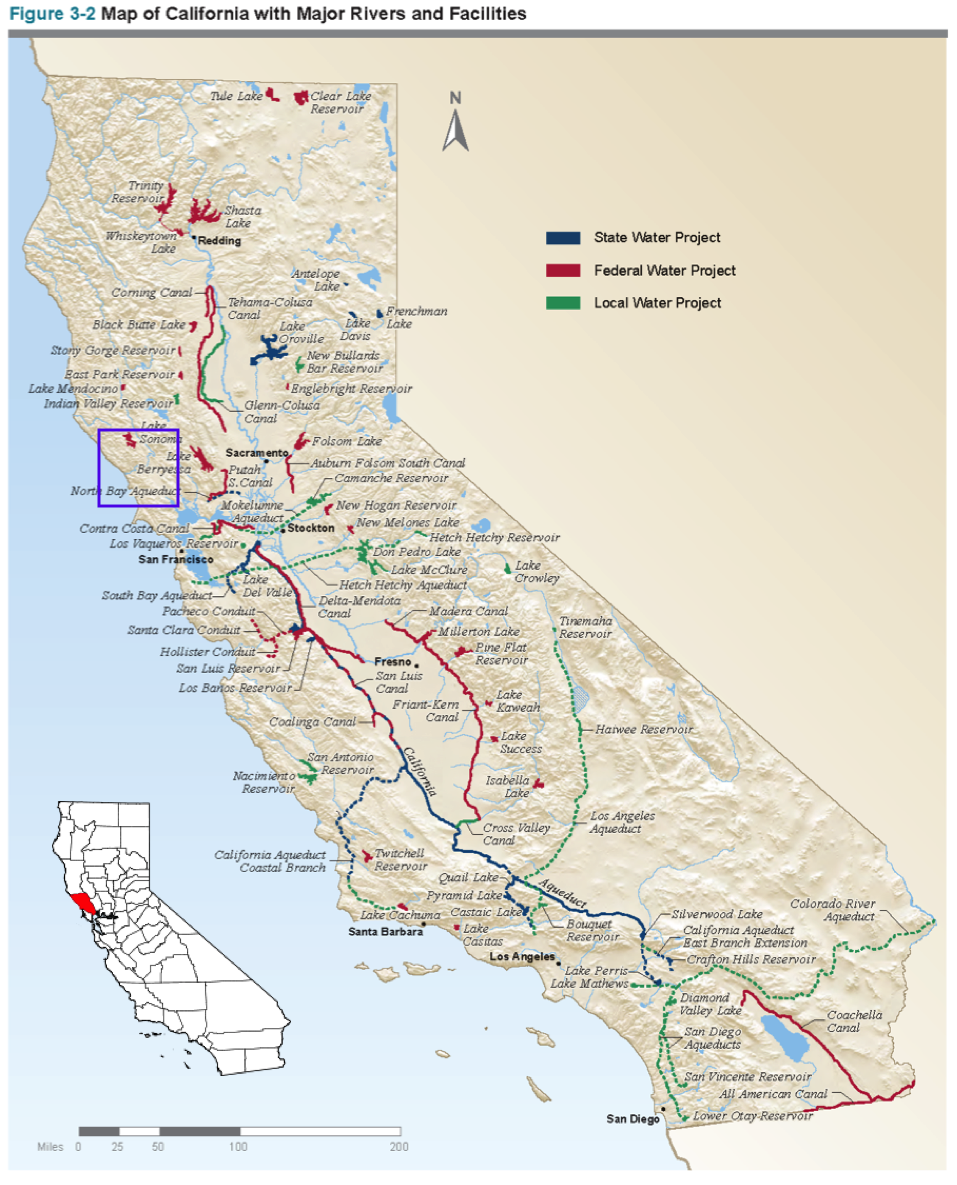
| 13:28, 13 November 2017 | CASalinas.png (file) |  |
1.22 MB | SamKumasaka | Map of water projects in California from the California Water Project with Salinas County highlighted. | 1 |
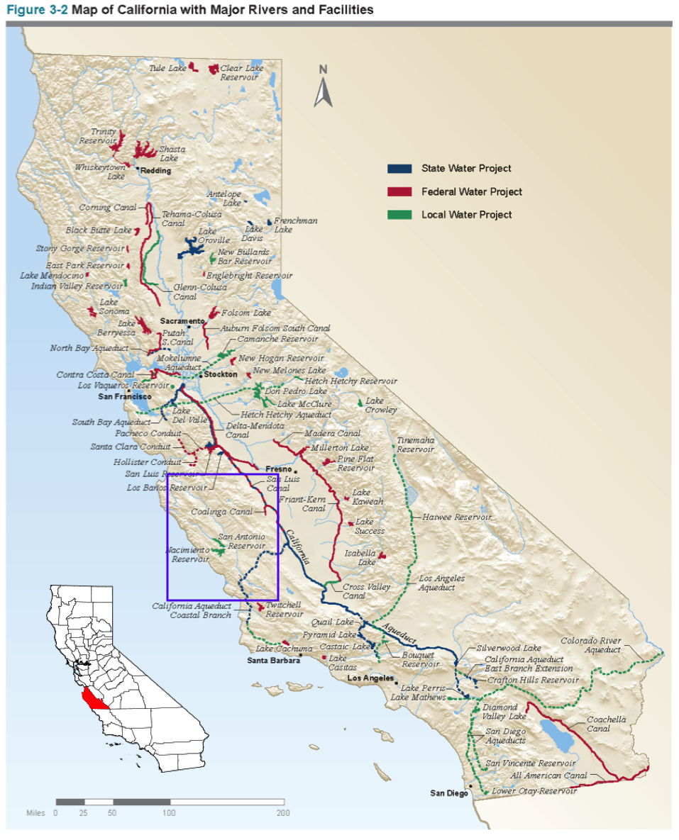
| 13:23, 13 November 2017 | CASonoma.png (file) |  |
1.23 MB | SamKumasaka | Map of California Water Projects and Sonoma County | 1 |
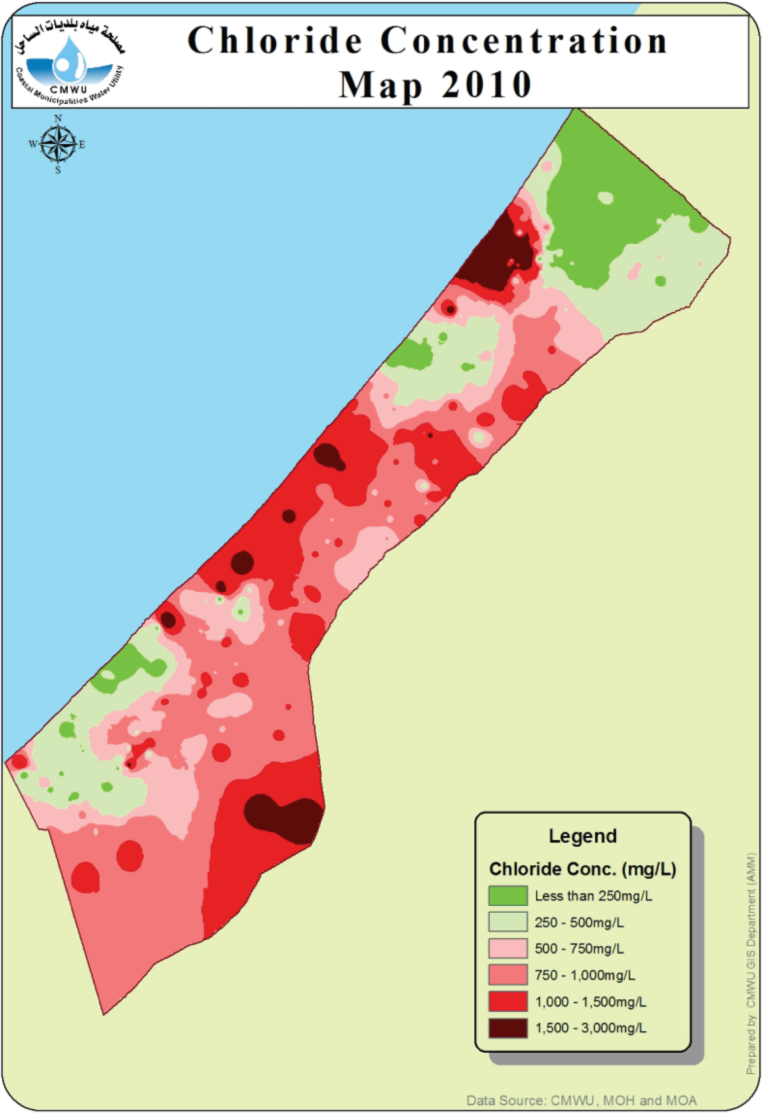
| 13:00, 26 June 2014 | CMWU-2010-chloride.png (file) |  |
280 KB | Amanda | From CMWU Annual Report 2010, Coastal Municipalties Water Utility, Palestine, 2011. Online at: http://www.cmwu.ps/en/yreports.php?view=17 | 1 |
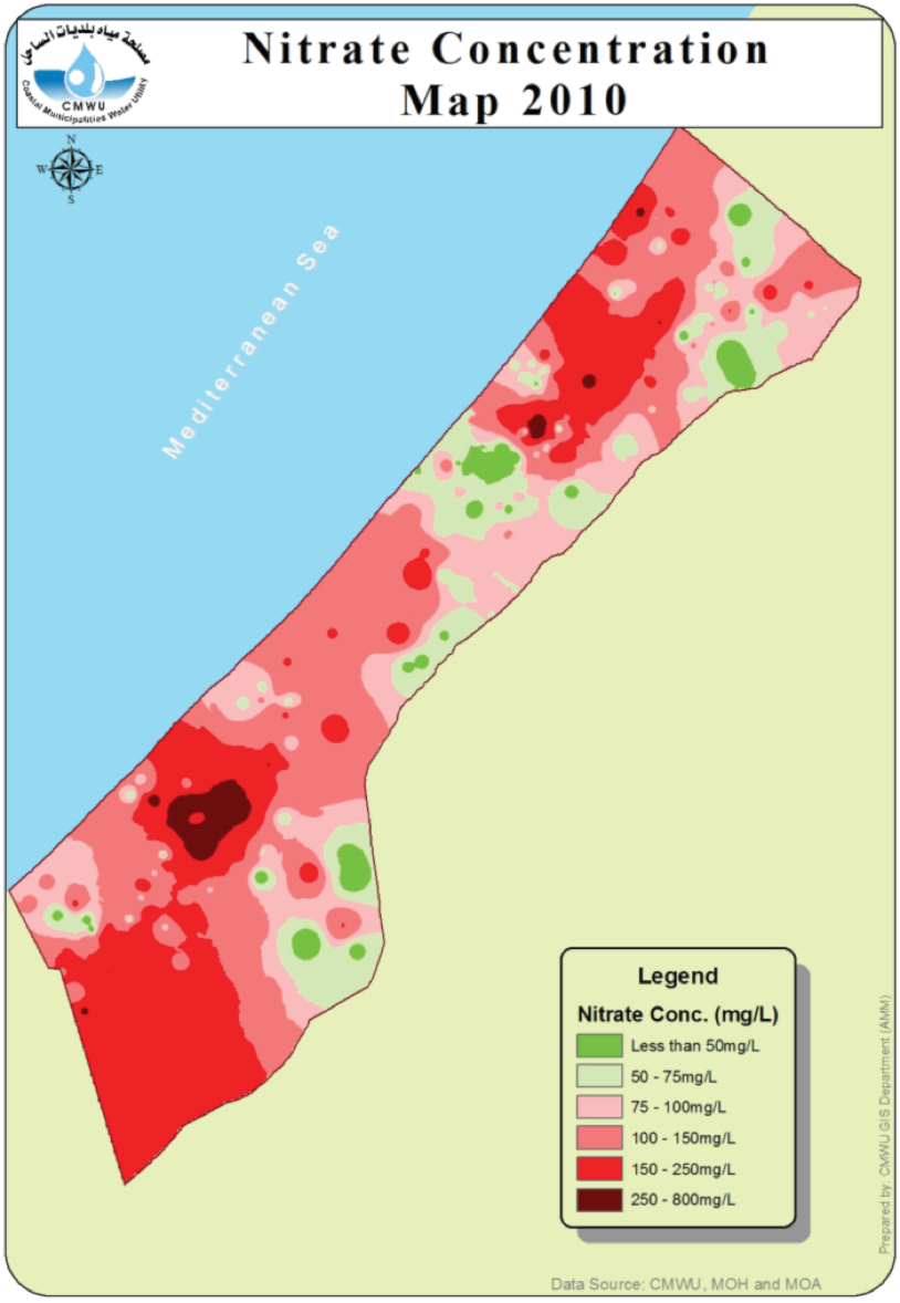
| 13:01, 26 June 2014 | CMWU-2010-nitrate.png (file) |  |
313 KB | Amanda | From CMWU Annual Report 2010, Coastal Municipalities Water Utility, Palestine, 2011. Online at: http://www.cmwu.ps/en/yreports.php?view=17 | 1 |
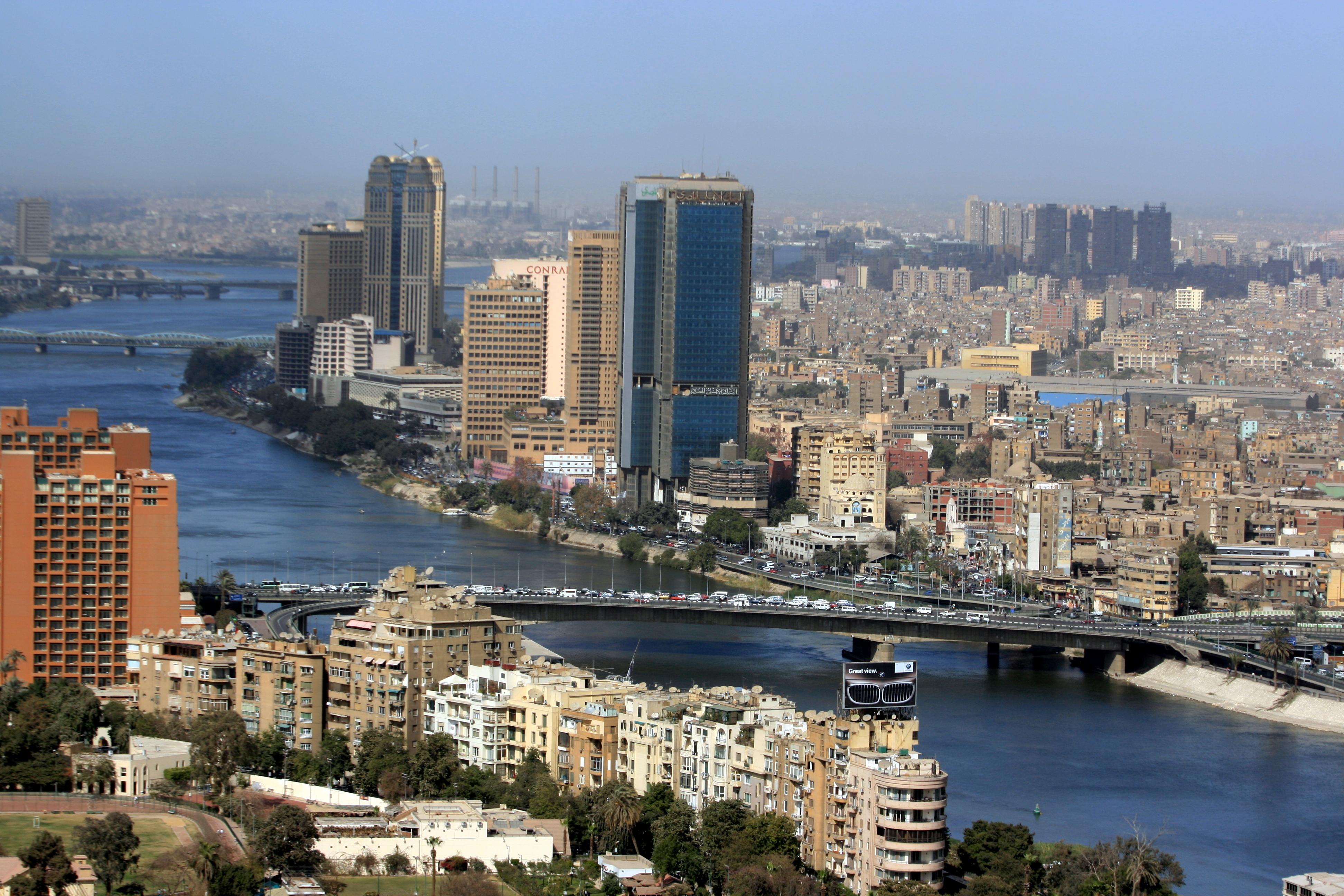
| 17:28, 21 December 2015 | Cairo02.jpg (file) |  |
1.18 MB | Agustinbotteron | 1 | |
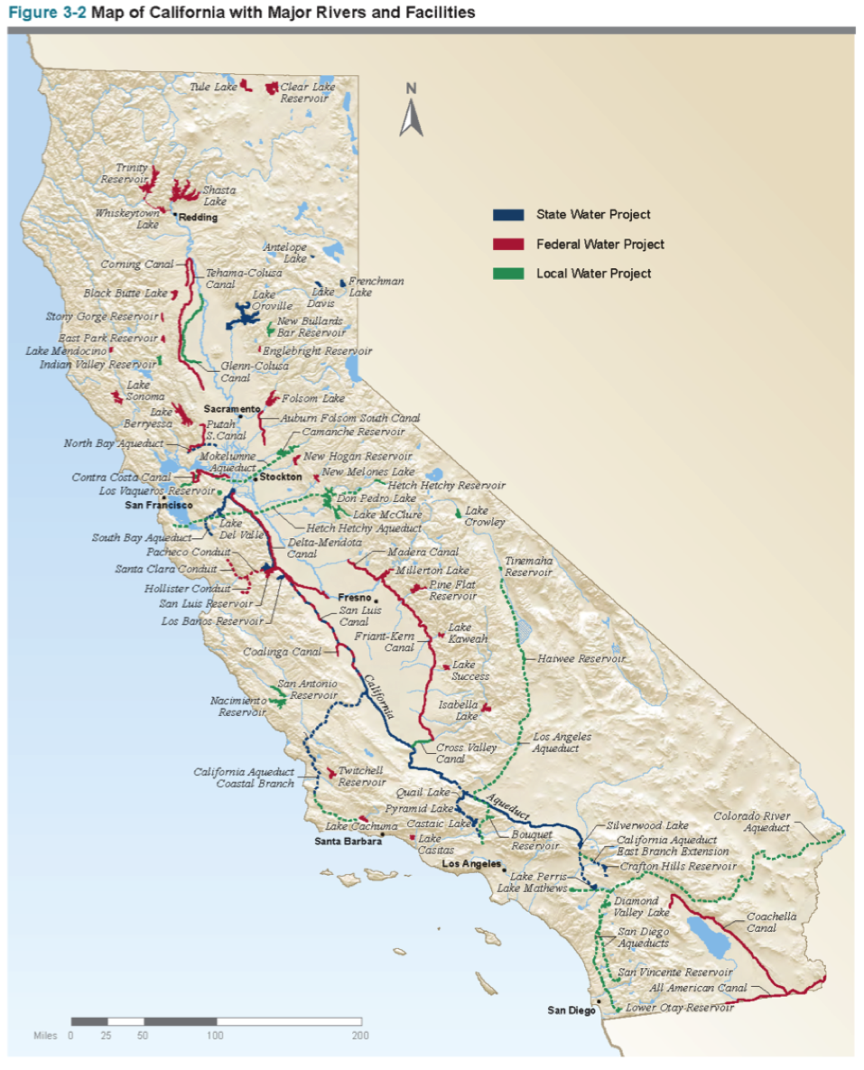
| 17:43, 31 October 2017 | CaliforniaWater.png (file) |  |
1.19 MB | SamKumasaka | A map of California with major waterways from the California Water Plan | 1 |
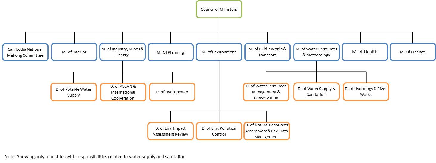
| 12:46, 20 May 2013 | Cambodia Governance.jpg (file) |  |
72 KB | TAlarcon | Created by Tania Alarcon Data Source: Phnom Penh Water Supply Authority. (2013). History. Organization Structure. Production System. Distribution System. Water Quality. Non Revenue Water. Retrieved from: www.ppwsa.com.kh/en/index.php?page=history Wate | 1 |
| 14:51, 17 May 2013 | Cambodia map.jpg (file) |  |
51 KB | TAlarcon | Graphic Produced by Tania Alarcon Adapted from Wikipedia | 1 |
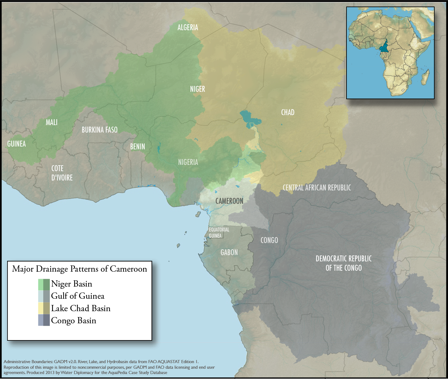
| 15:48, 23 September 2013 | Cameroon-regional-overview.png (file) |  |
1.43 MB | Amanda | An overview map showing Cameroon within the context of the 4 major drainage patterns: Niger Basin, Lake Chad, Congo Basin, and Gulf of Guinea. Produced by Water Diplomacy for Cameroon-related articles Data Sources: GADM v2.0 (Administrative Boundarie... | 1 |
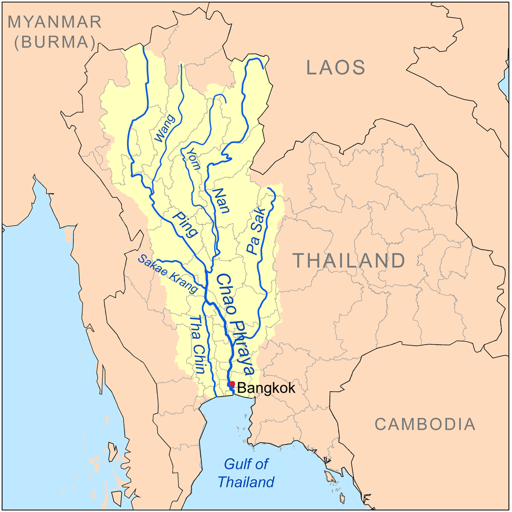
| 21:01, 30 April 2014 | Chaophrayarivermap.png (file) |  |
391 KB | TSP | The Chao Phraya River and its Tributaries Source: http://en.wikipedia.org/wiki/Tributaries_of_the_Chao_Phraya_River | 1 |
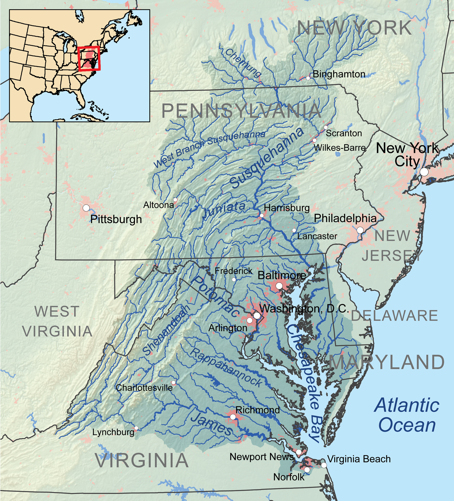
| 22:30, 15 May 2017 | Chesapeakewatershedmap.png (file) |  |
2.79 MB | Ncohen | Map of the Chesapeake Bay Watershed | 1 |
| 22:36, 26 March 2012 | Chronology.jpg (file) |  |
43 KB | Administrator | 1 |
First page |
Previous page |
 Next page |
Last page |


