File list
This special page shows all uploaded files.
| Name | Thumbnail | Size | User | Description | Versions | |
|---|---|---|---|---|---|---|
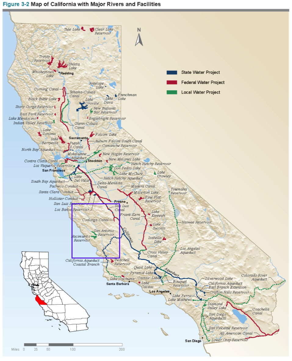
| 13:28, 13 November 2017 | CASalinas.png (file) |  |
1.22 MB | SamKumasaka | Map of water projects in California from the California Water Project with Salinas County highlighted. | 1 |
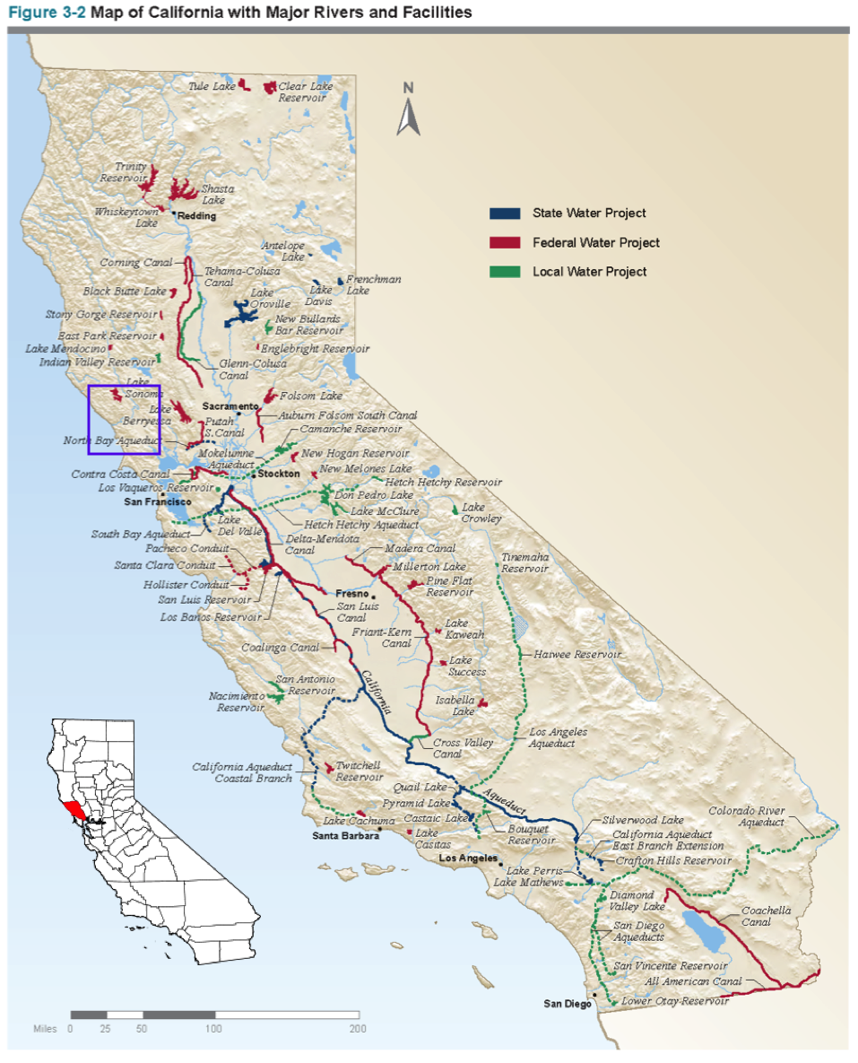
| 13:23, 13 November 2017 | CASonoma.png (file) |  |
1.23 MB | SamKumasaka | Map of California Water Projects and Sonoma County | 1 |
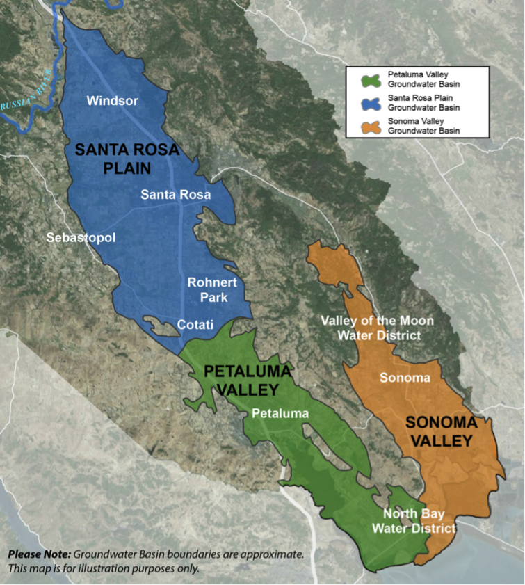
| 10:18, 1 November 2017 | SonomaBasins.png (file) |  |
1.2 MB | SamKumasaka | The three groundwater basins in Sonoma County designated medium-priority: Santa Rosa Plain, Petaluma Valley, and Sonoma Valley Basins Source: CASGEM | 1 |
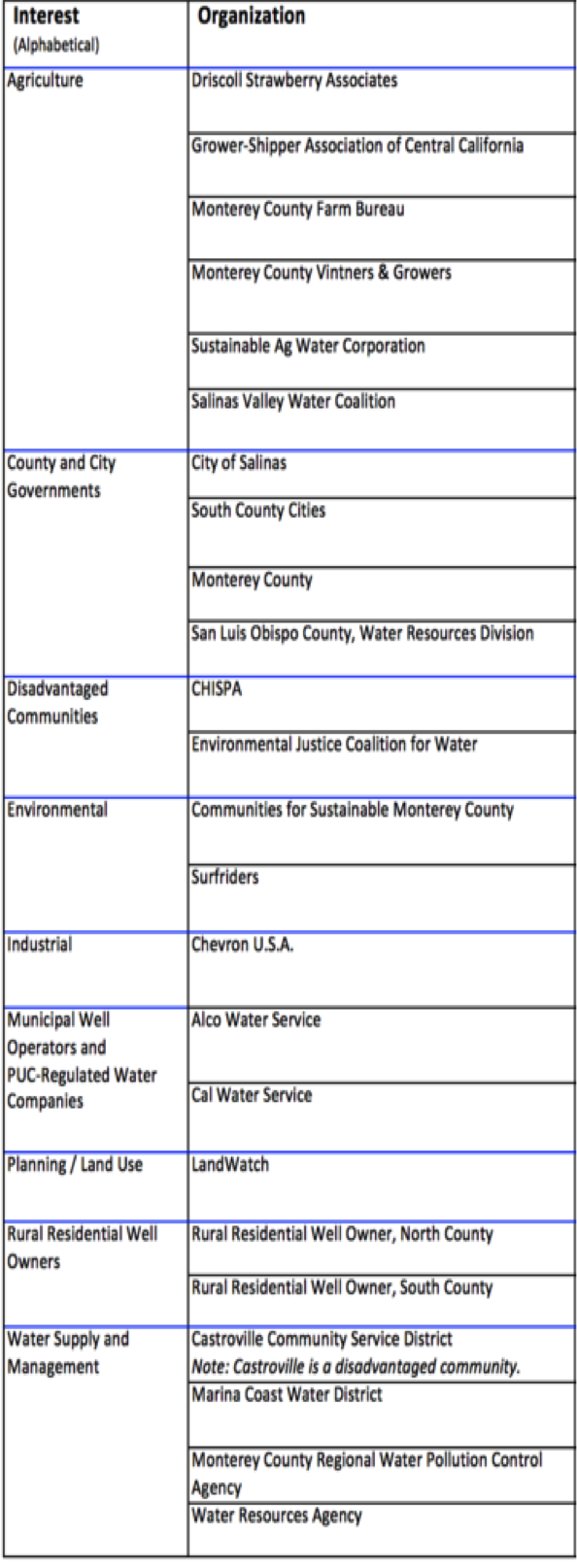
| 10:13, 1 November 2017 | Sal7.png (file) |  |
407 KB | SamKumasaka | Salinas Valley Groundwater Advisory Committee Represented Organizations | 1 |
| 10:10, 1 November 2017 | Sal6.png (file) |  |
207 KB | SamKumasaka | DIAGRAM: Groundwater Stakeholder Forum, Collaborative Work Group, and Committee Meetings | 1 |
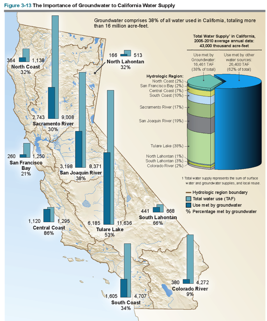
| 10:07, 1 November 2017 | Sal5.png (file) |  |
1.06 MB | SamKumasaka | The Importance of Groundwater to California Water Supply Groundwater comprises 38% of all water used in California, totaling more than 16 million acre-feet. Source: CA DWR | 1 |
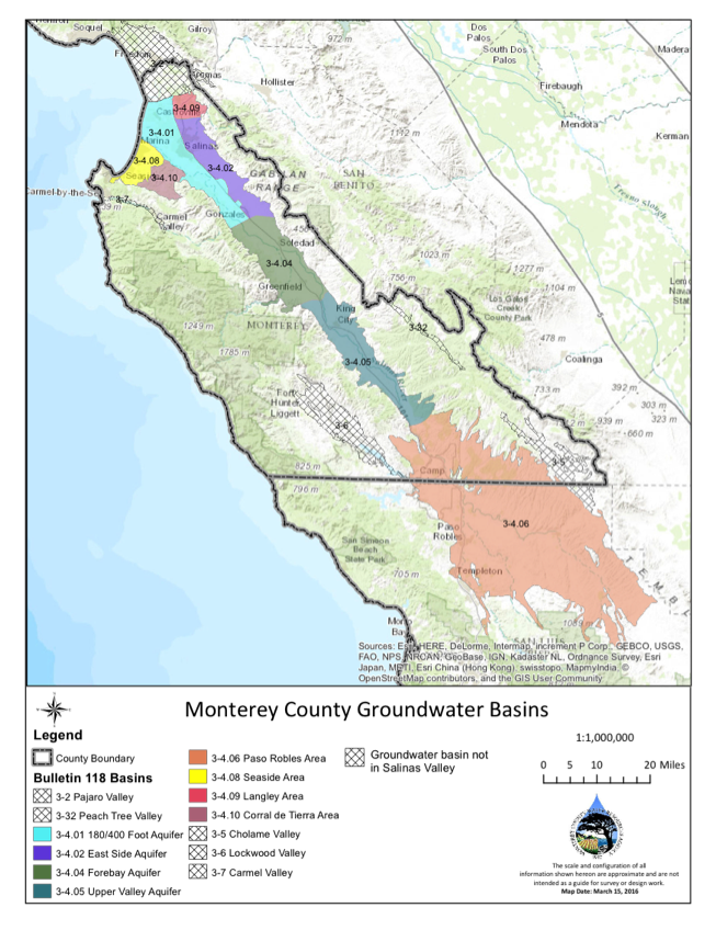
| 10:04, 1 November 2017 | Sal4.png (file) |  |
697 KB | SamKumasaka | Monterey County Groundwater Sub-basins | 1 |
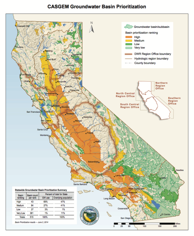
| 09:59, 1 November 2017 | Sal3.png (file) |  |
626 KB | SamKumasaka | CASGEM Groundwater Basin Prioritization | 1 |
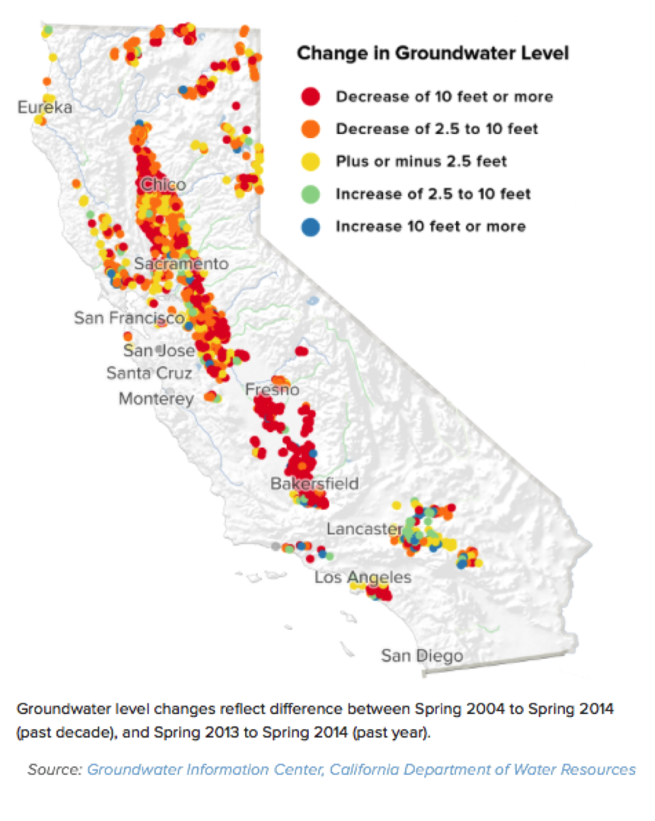
| 09:57, 1 November 2017 | Sal2.png (file) |  |
620 KB | SamKumasaka | Change in Groundwater Level 2004-2014 Groundwater Information Center, CA Department of Water Resources | 1 |
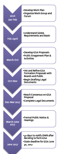
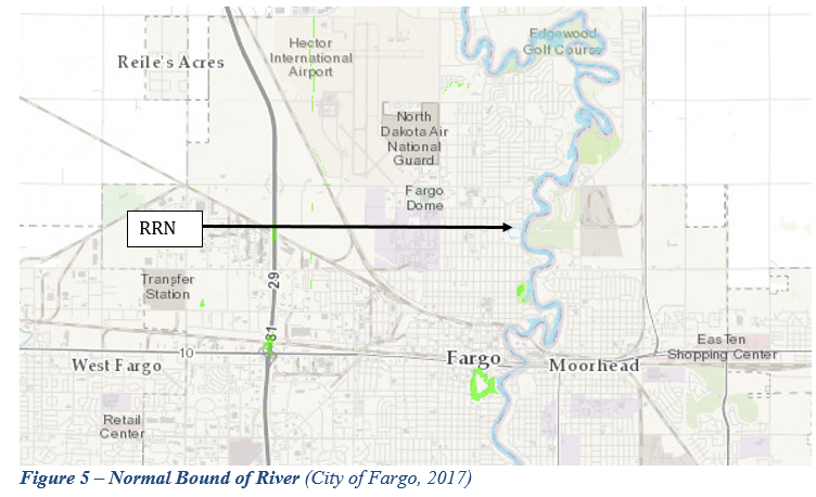
| 18:19, 31 October 2017 | Salinas GSA Process Roadmap.png (file) |  |
43 KB | SamKumasaka | Process Roadmap for SGMA Implementation/GSA Formation in Salinas Valley Groundwater Basin Created by Gina Bartlett (CBI, 2016) - https://www.svbgsa.com/process-timeline/ | 1 |
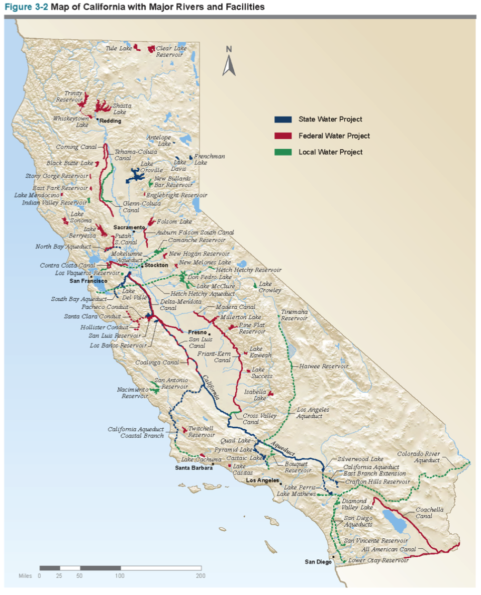
| 17:43, 31 October 2017 | CaliforniaWater.png (file) |  |
1.19 MB | SamKumasaka | A map of California with major waterways from the California Water Plan | 1 |
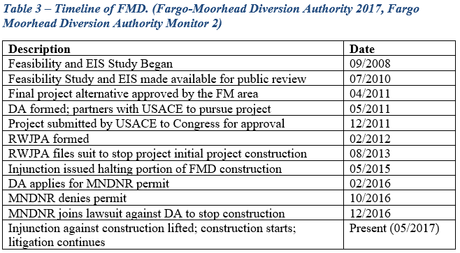
| 20:03, 6 June 2017 | Table 3.PNG (file) |  |
37 KB | Gtbrien | 3 | |
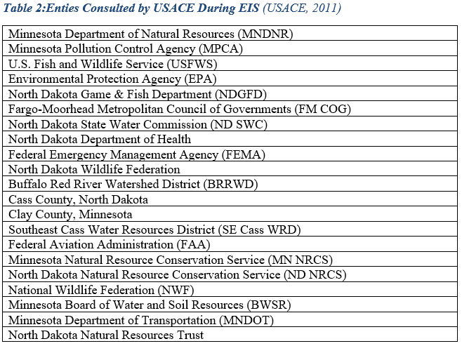
| 20:03, 6 June 2017 | Table 2.PNG (file) |  |
50 KB | Gtbrien | 4 | |
| 20:02, 6 June 2017 | Figures 1 and 2.PNG (file) |  |
188 KB | Gtbrien | 4 | |
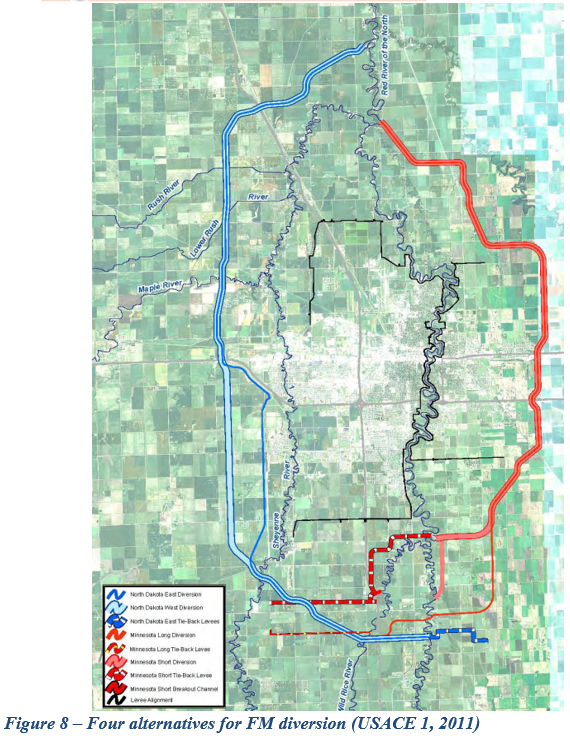
| 20:02, 6 June 2017 | Figure 8.PNG (file) |  |
978 KB | Gtbrien | 3 | |
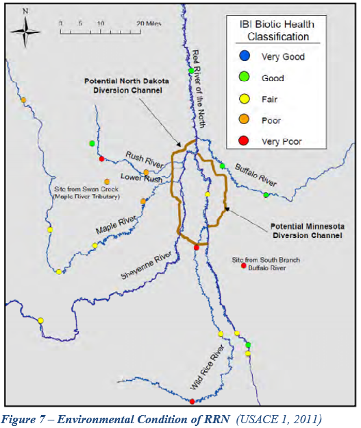
| 20:01, 6 June 2017 | Figure 7.PNG (file) |  |
376 KB | Gtbrien | 3 | |
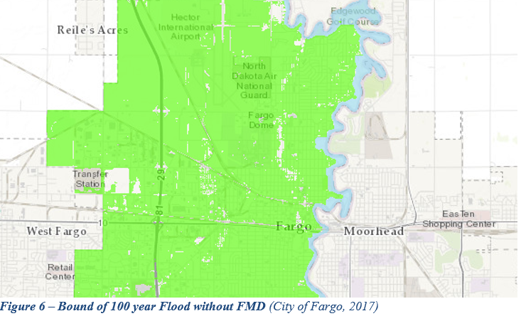
| 20:01, 6 June 2017 | Figure 6.PNG (file) |  |
431 KB | Gtbrien | 3 | |
| 20:00, 6 June 2017 | Figure 5.PNG (file) |  |
422 KB | Gtbrien | 3 | |
| 20:00, 6 June 2017 | Figure 4.PNG (file) |  |
218 KB | Gtbrien | 3 | |
| 19:59, 6 June 2017 | Figure 3.PNG (file) |  |
565 KB | Gtbrien | 3 | |
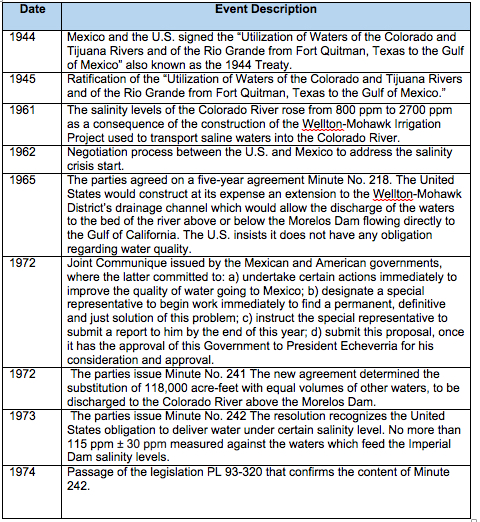
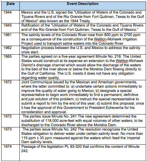
| 19:51, 6 June 2017 | Table 1.PNG (file) |  |
15 KB | Gtbrien | 2 | |
| 19:47, 6 June 2017 | TEST.PNG (file) |  |
423 KB | Gtbrien | 1 | |
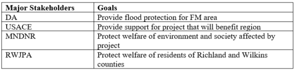
| 19:53, 5 June 2017 | Stakeholders1.PNG (file) | 27 KB | Gtbrien | 1 | ||
| 19:42, 5 June 2017 | Stakeholders.PNG (file) | 27 KB | Gtbrien | Stakeholder | 1 | |
| 14:54, 5 June 2017 | Timetable22017-06-05 14.44.31.jpg (file) |  |
564 KB | Jimena SG | 1 | |
| 14:09, 5 June 2017 | Timetable 2017-06-05 14.03.22.jpg (file) |  |
579 KB | Jimena SG | 1 | |
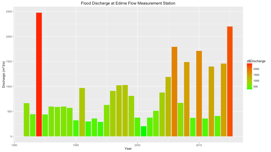
| 16:36, 29 May 2017 | MaritsaFlow.png (file) |  |
44 KB | OzgurB | 1 | |
| 13:06, 26 May 2017 | Test.png (file) |  |
4 KB | Gtbrien | 1 | |
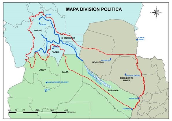
| 18:32, 25 May 2017 | Map PilcomayoBasin.jpg (file) |  |
49 KB | Julian Kölbel | This map delineates the Pilcomayo River Basin and shows how it is shared between the riparian states Bolivia, Paraguay, and Argentina. It also shows how the Pilcomayo forms extensive wetlands at the border between Paraguay and Argentina, called the Ban... | 2 |
| 10:41, 25 May 2017 | -Chart-01-SouthChinaSea Figures-.png (file) |  |
328 KB | Pjular | 1 | |
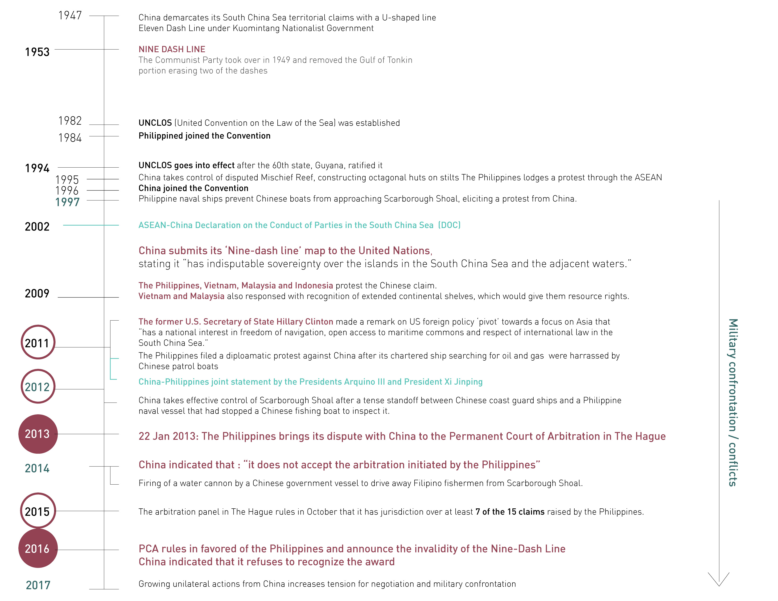
| 10:41, 25 May 2017 | -Timeline01 SouthChinaSea ChinavsPhilippines-.jpg (file) |  |
874 KB | Pjular | 1 | |
| 10:41, 25 May 2017 | -MAP-08 SouthChinaSea ChinavsVietnam-.jpg (file) |  |
419 KB | Pjular | 1 | |
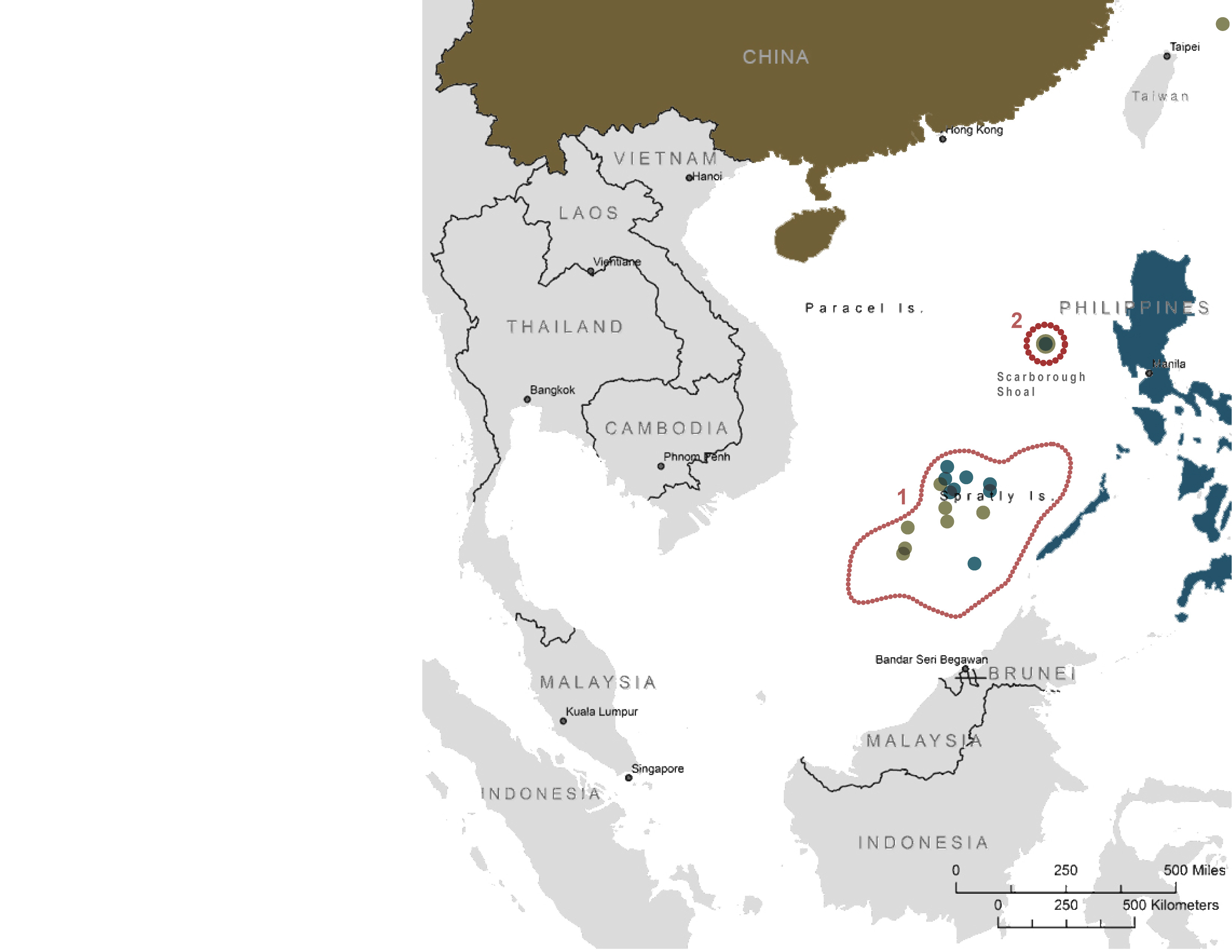
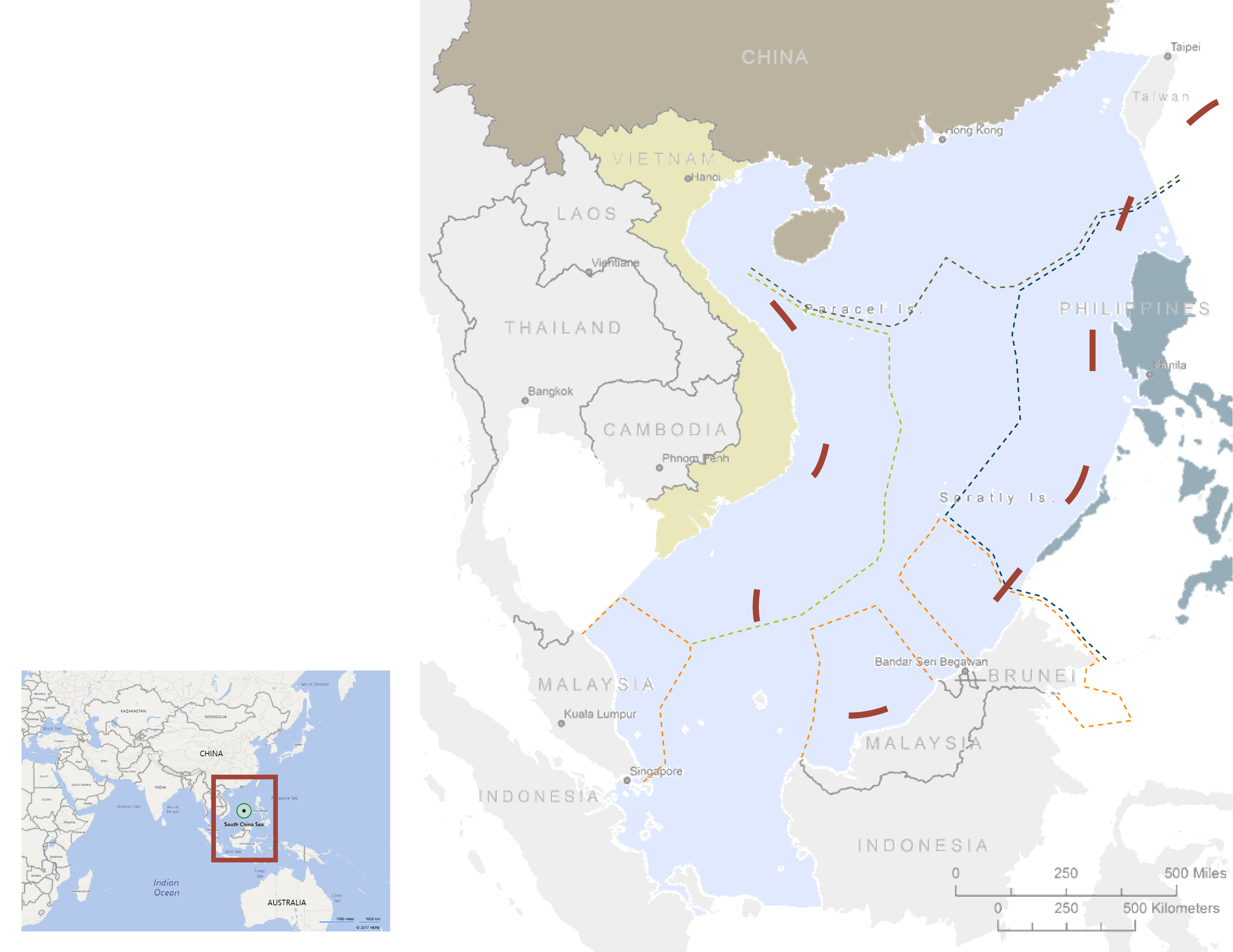
| 10:40, 25 May 2017 | -MAP-07 SouthChinaSea ChinavsPhilippines-.jpg (file) |  |
411 KB | Pjular | 1 | |
| 10:40, 25 May 2017 | -MAP-06 SouthChinaSea Oil and Natural Gas Platform-.jpg (file) |  |
487 KB | Pjular | 1 | |
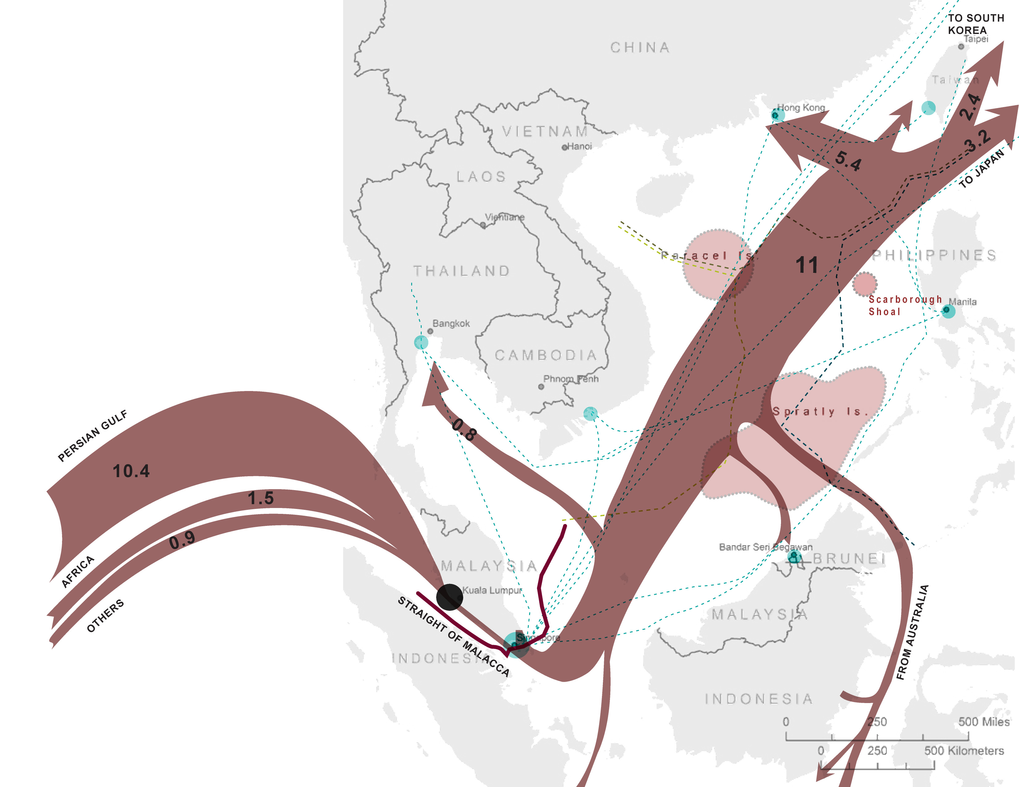
| 10:39, 25 May 2017 | -MAP-05 SouthChinaSea Crude oil trade flow-.jpg (file) |  |
671 KB | Pjular | 1 | |
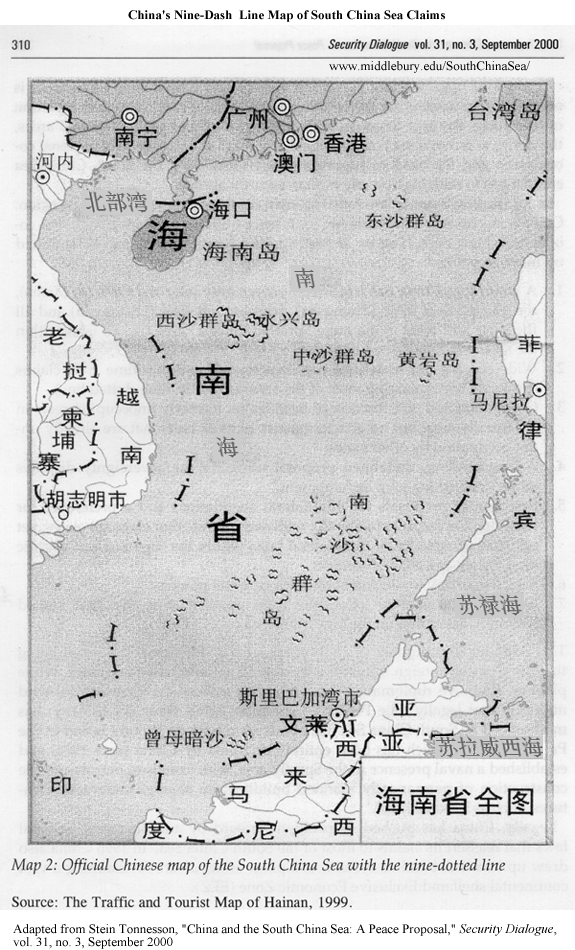
| 10:38, 25 May 2017 | -MAP-03 SouthChinaSea Nine dash line historical map-.gif (file) |  |
463 KB | Pjular | 1 | |
| 10:38, 25 May 2017 | -MAP-01 SouthChinaSea MaritimeTerritory-.jpg (file) |  |
205 KB | Pjular | 1 | |
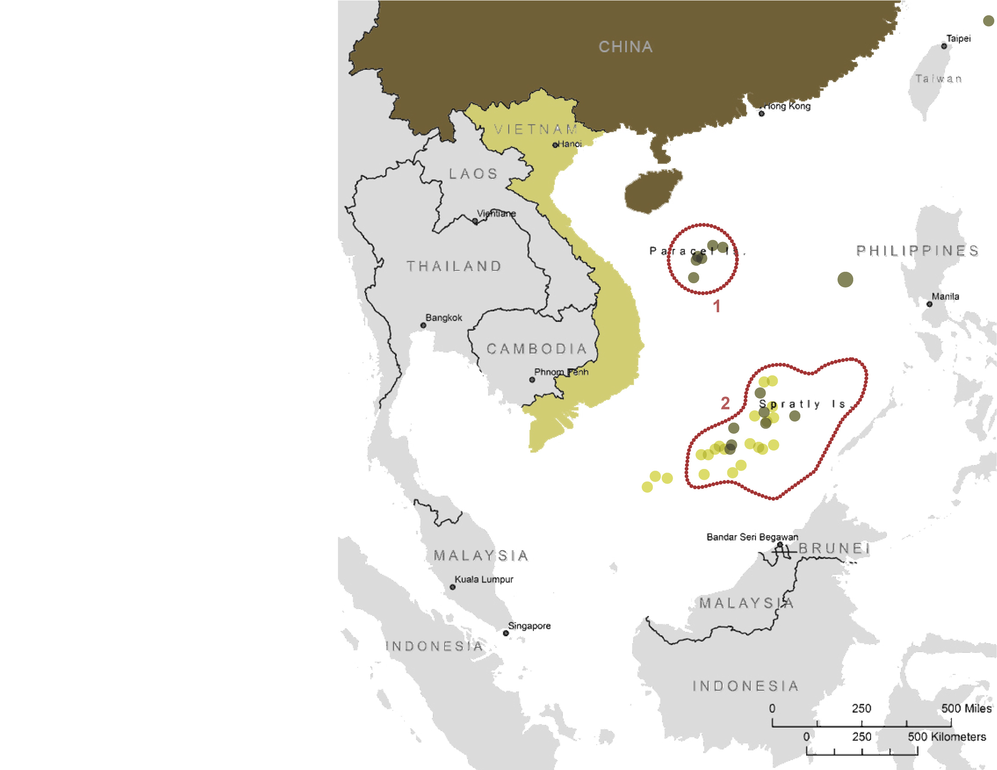
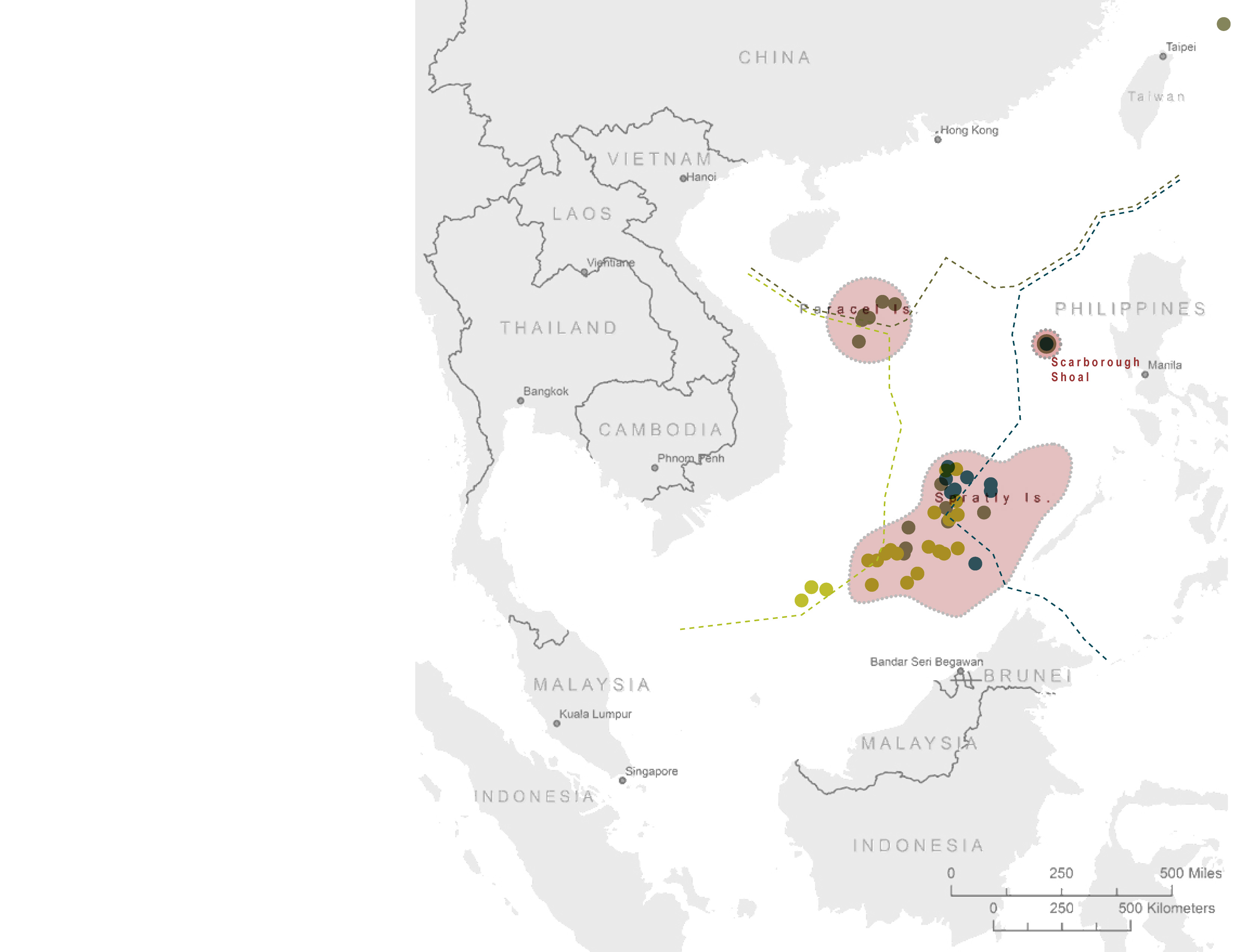
| 10:37, 25 May 2017 | -MAP-04 SouthChinaSea Islands in dispute-.jpg (file) |  |
353 KB | Pjular | 1 | |
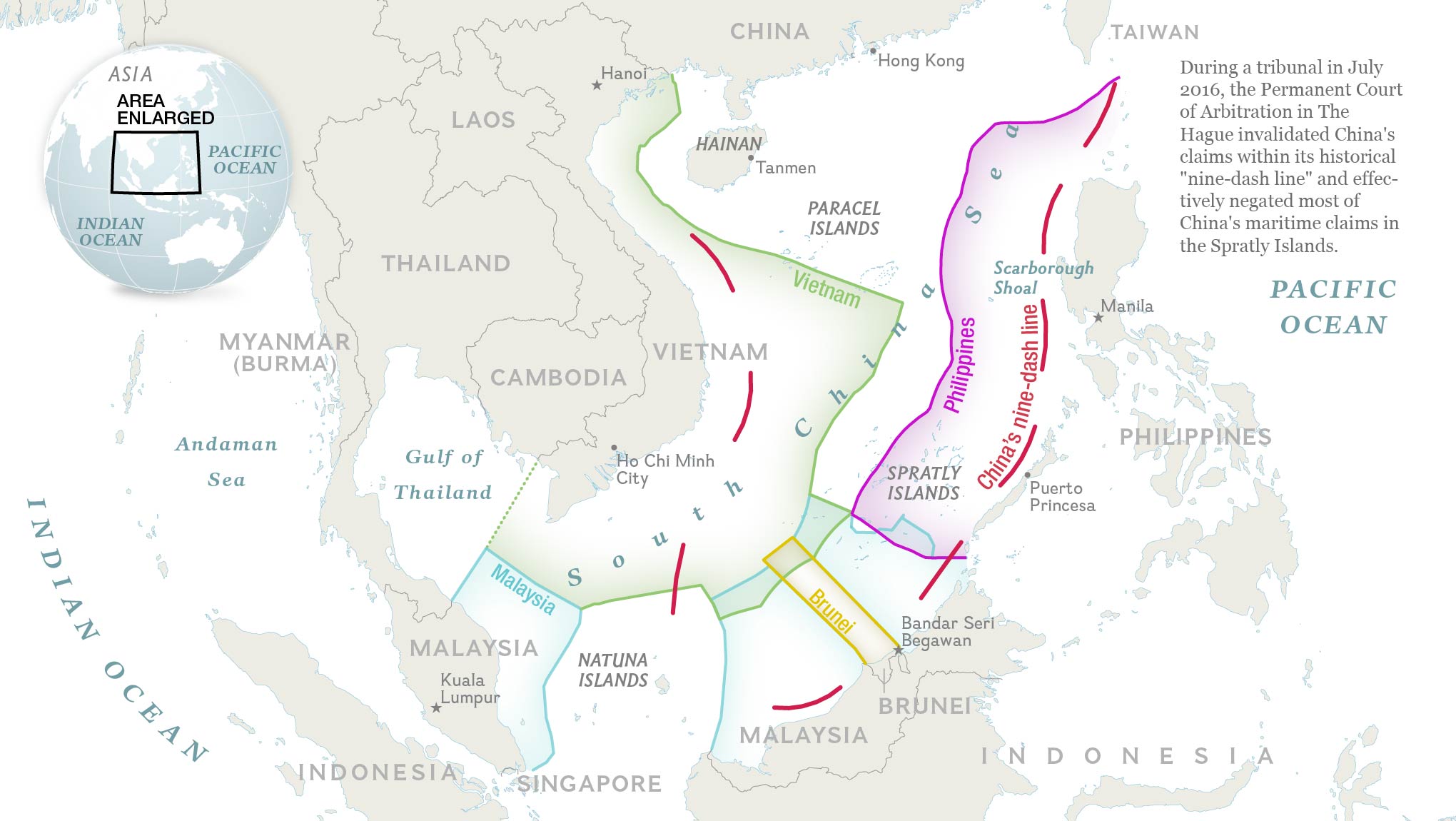
| 10:30, 25 May 2017 | -MAP-02 SouthChinaSea Nine dash line claim-.jpg (file) |  |
544 KB | Pjular | 1 | |
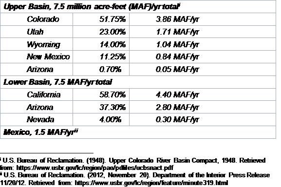
| 10:23, 25 May 2017 | ColoradoRiver Allocations.png (file) |  |
25 KB | Keefe | 1 | |
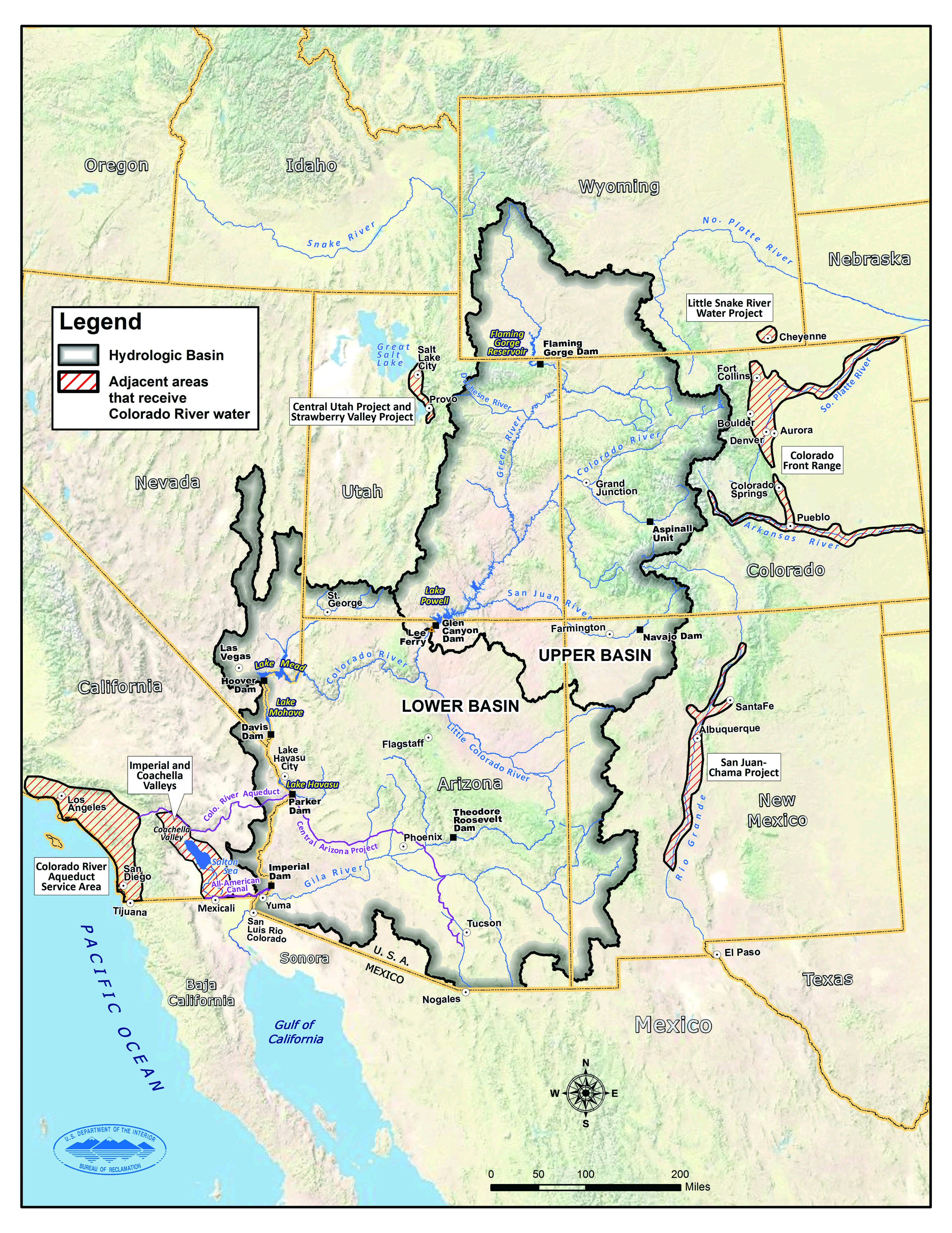
| 10:19, 25 May 2017 | Map coloradoriverbasin.jpg (file) |  |
1.37 MB | Keefe | Source: https://www.usbr.gov/lc/region/programs/crbstudy.html | 1 |
| 10:15, 25 May 2017 | Map.jpg (file) |  |
1.37 MB | Keefe | Source: https://www.usbr.gov/lc/region/programs/crbstudy.html | 1 |
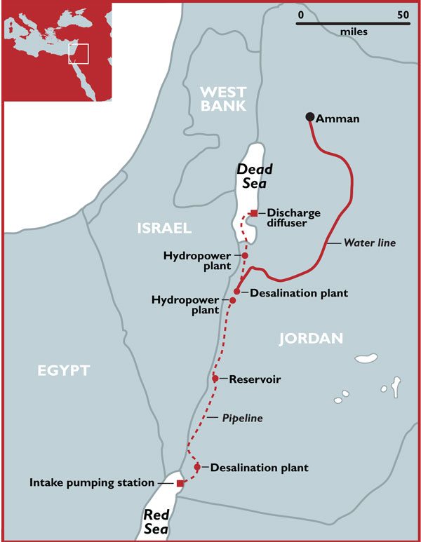
| 07:24, 25 May 2017 | Red-dead-sea.jpg.scale.LARGE.jpg (file) |  |
48 KB | Stolgay | The Red to Dead Sea Conveyance project includes a 180-kilometre pipeline engineered to carry up to two billion cubic metres of seawater per year from the Gulf of Aqaba on the Red Sea through Jordanian territory to the Red Sea as well as hydropower plan... | 1 |
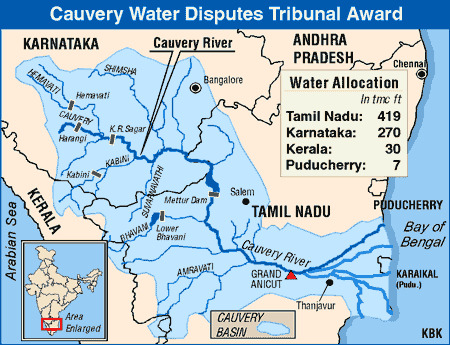
| 20:32, 24 May 2017 | Main-qimg-5ae85ce6607bb653b8c34f587c6be1ea.gif (file) |  |
26 KB | Shekharc | Cauvery River Basin Source: The Economic Times. Retrieved on May 24, 2017. | 1 |
| 20:25, 23 May 2017 | Water Diplomacy Study Casevf.docx (file) | 159 KB | Jimena SG | 1 | ||
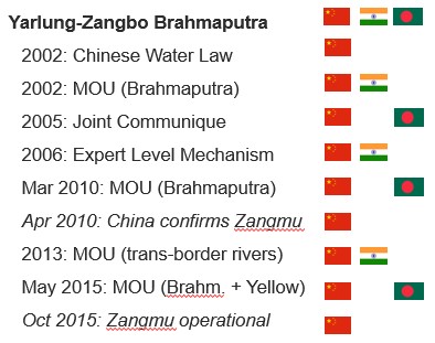
| 16:41, 23 May 2017 | Visual Timeline of bilateral cooperation on the Yarlung Zangbo-Brahmaputra and the Zangmu Dam.jpg (file) |  |
38 KB | Cindynoe | 1 | |
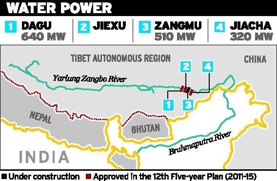
| 16:41, 23 May 2017 | Zangmu Dam and other planned Chinese dams on the Yarlung Zangbo-Brahmaputra.jpg (file) |  |
68 KB | Cindynoe | 1 | |
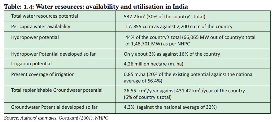
| 16:40, 23 May 2017 | Fig 4. Water Resources - Availability and Utilization in India.jpg (file) |  |
101 KB | Cindynoe | 1 | |
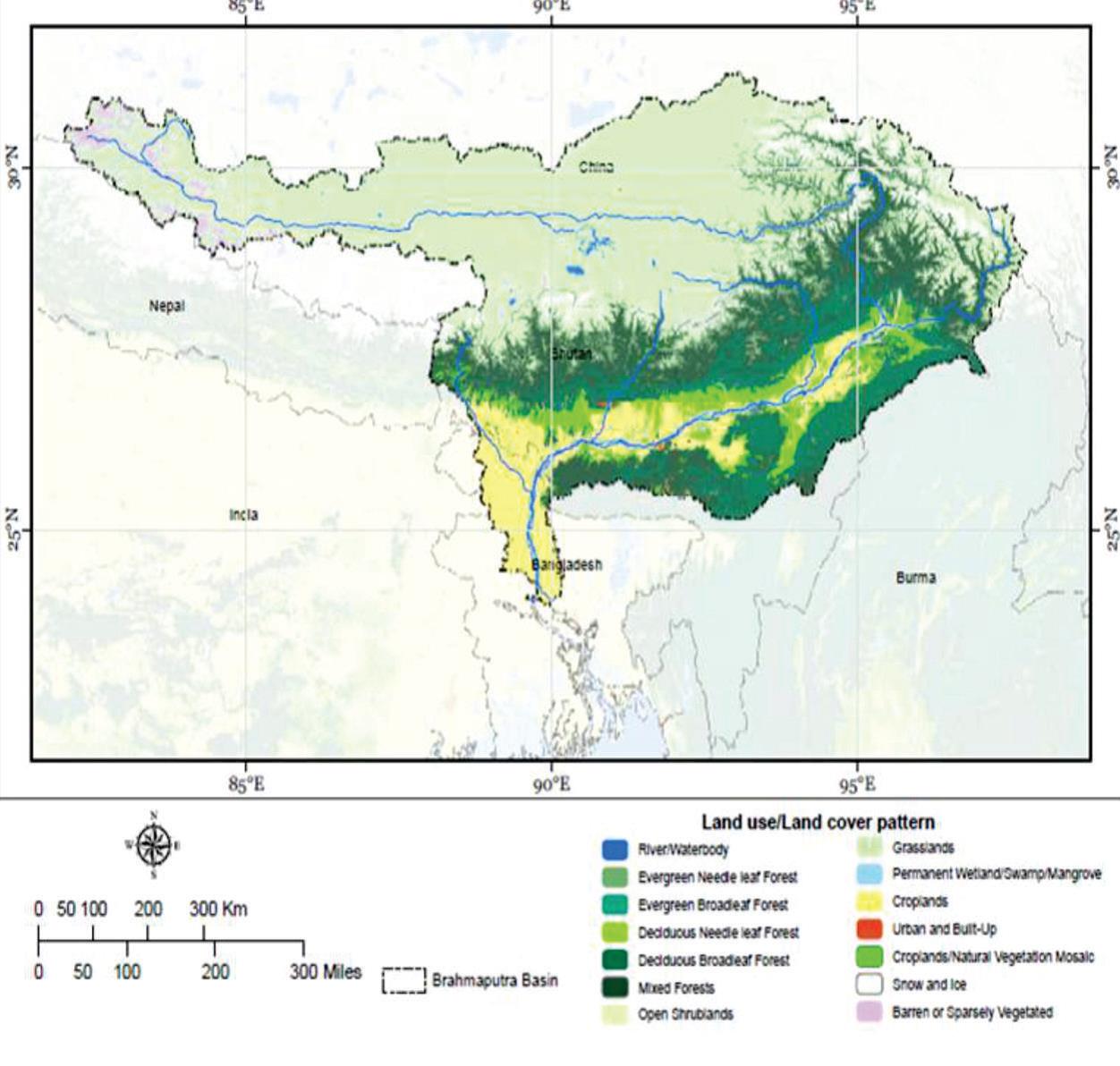
| 16:16, 23 May 2017 | Land Use Land Cover in the Brahmaputra sub-basin.jpg (file) |  |
132 KB | Cindynoe | 1 | |
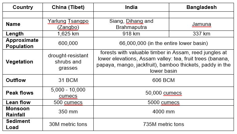
| 16:16, 23 May 2017 | Yarlung Zangbo Brahmaputra key basin statistics country by country.jpg (file) |  |
84 KB | Cindynoe | 1 |
First page |
Previous page |
Next page |
Last page |


