File:UNOSAT IND Bihar Floods ASAR 31Aug08 Lowres.png
Summary
high-res .pdf available online: http://www.unitar.org/unosat/node/44/1259
Product ID: 1259 - English Published: 1 Sep, 2008 GLIDE: FL-2008-000145-IND
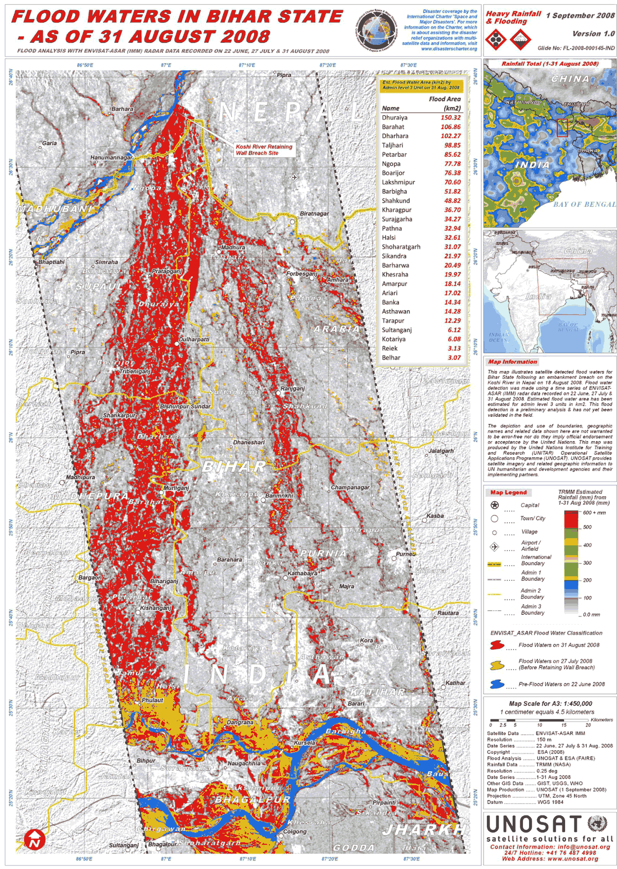
“This map illustrates satellite detected flood waters for Bihar State following an embankment breach on the Koshi River in Nepal on 18 August 2008. Flood water detection was made using a time series of ENVISAT-ASAR (IMM) radar data recorded on 22 June, 27 July & 31 August 2008. Estimated flood water area has been estimated for admin level 3 units in km2. This flood detection is a preliminary analysis & has not yet been validated in the field.”
Scale for A3: 1:450,000; Projection : UTM, Zone 45 North; Datum : WGS 1984 Satellite Data : ENVISAT-ASAR IMM Resolution : 150 m Date Series : 22 June, 27 July & 31 Aug. 2008 Copyright : ESA (2008) Flood Analysis : UNOSAT & ESA (FAIRE) Rainfall Data : TRMM (NASA) Resolution : 0.25 deg Date Series :1-31 Aug 2008 Other GIS Data : GIST, USGS, WHO Map Production : UNOSAT (1 September 2008)
This unmodified, low-res representation of the map product available at the above link is included in accordance with UN and ESA guidelines for use of their publically available data products. This image cannot be reproduced for commercial use or modified in any way.
Licensing
Files listed as having license "other" do not conform to a standard public domain or creative commons standard.
This may be a file that has been included with the express permission of the creator/owner, or it may be included under the fair-use exclusion. AquaPedia will remove any files which are obviously presented in violation of their copyright, or at the request of the content owner.
Please see the file summary for more info. If you added this file, please annotate the file summary with information about the file and its terms of use and reason it was included.
File history
Click on a date/time to view the file as it appeared at that time.
| Date/Time | Thumbnail | Dimensions | User | Comment | |
|---|---|---|---|---|---|
| current | 17:03, 25 June 2013 | | 1,200 × 1,689 (595 KB) | Amanda (Talk | contribs) | high-res .pdf available online: http://www.unitar.org/unosat/node/44/1259 Product ID: 1259 - English Published: 1 Sep, 2008 GLIDE: FL-2008-000145-IND “This map illustrates satellite detected flood waters for Bihar State following an embankment brea... |
- You cannot overwrite this file.
File usage
The following page links to this file:


